The heavy rain mode of many places in Guangdong continues!Why is the typhoon away, or is it rain and rain?
Author:Global Times Time:2022.07.04
Two days on the weekend,
"Siaba" rain brought by Typhoon No. 3
Well, it's all the way to stop
Native
How about the next weather?
Typhoon away from the latter monsoon again!
Next is the wind and rain mode
According to@Guangdong weather:
During this typhoon,
From 20:00 on June 30th to 20:00 on July 3
Most of Guangdong appears more than 100 mm precipitation,
Partial precipitation time is longer
Precipitation above 250 mm,
Maoming and Yangjiang, which are the most affected by it,
Cumulative precipitation of more than 500 mm was recorded.

Affected by "Siaba" and Southwest monsoon
The rain is still obvious in the next few days
At present, although "Siaba" is weakened to a tropical storm, its strength is still strong. As the system go northward, "Siaba" and its weakened low -voltage circulation and western wind slots will work together, which will bring heavy precipitation.
"Siam" is still strong after landing
According to Zhang Ling, chief forecast at the Central Meteorological Typhoon, usually the strength will be greatly reduced after the typhoon landing. However, on the morning of July 3, although the mountains and ridges consumed some energy, the "Siaba" posture was still "rounded" -s means that its structure is still basically complete, just like a huge "hot machine", which is sufficient to be sufficient. The water vapor is continuously involved, rising, and throwing.
As the first typhoon to land in my country this year, under the blessing of the monsoon belt, "Siaba" brought storms to South China before and after landing. From 8:00 on July 2nd to 8:00, heavy rain or heavy rain appeared in Hainan Island, central and western parts of Guangdong, southern, eastern Guangxi, and southeastern Fujian. Among them, East, East, and Laizhou in Hainan, Maoming, Guangdong, and Yangjianghe Shantou, Guangxi Yulin and other territories appeared heavy rain.
"Siam" goes north to prevent strokes from intended
According to the forecast of the Central Meteorological Observatory, on the 4th, "Siaba" will enter Hunan with a tropical low pressure. After the typhoon landing does not mean that the danger is reduced, but the region needs to be more vigilant.
Although the water vapor conditions are weaker than the sea after the "Saudi" landing, it still maintains a smooth water vapor channel. In addition to the large number of "sprinkle" during the typhoon body in the north, it will also bring heavy precipitation with other systems.
From the 3rd to 6th, due to the joint influence of the "Siam" and its weakened low -voltage circulation and Western wind grooves, Guangdong, Guangxi, Hunan, Hubei, Henan, Shandong, and northern Jiangsu and Anhui will appear heavy rainfall.
In addition, Typhoon "Avery" this year is located on the northwest Pacific Ocean, and will move north to northeast at a speed of about 10 kilometers per hour. The distance between "Siaba" and "Avey" has not directly affected each other, but the two have a connection by affecting the surrounding weather system. The two typhoon systems are like diligent "long -distance water transportation". They constantly transport the warm seawater south to the north, bringing more "raw materials" to the rainy northern region.
"Rain at work" is here again!
The yellow warning of heavy rain in Guangzhou is now taking effect
According to@Guangdong weather,
As of 5:50 in the morning
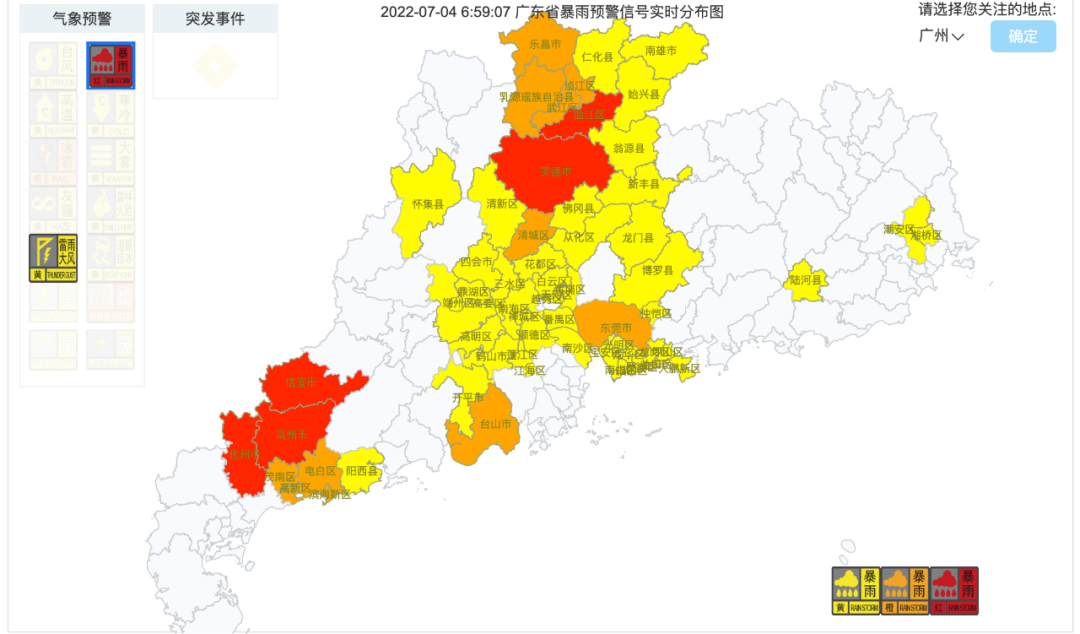
There are 34 heavy rain warning signals in Guangdong are taking effect
in,
Shaoguan Qujiang District, Yingde City,
Xinyi City, Gaozhou City, Huazhou City
Release of heavy rain red warning signals
It is expected that the precipitation will continue
Please pay attention to defense

Picture source: Guangdong Meteorological Bureau

As of 6:30 in the morning (4th),
Guangzhou
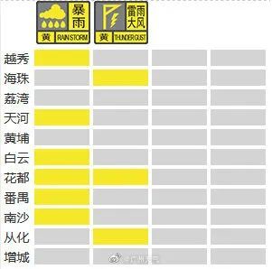
Rain rain yellow/thunderstorm and windy yellow warning signal
Take effect
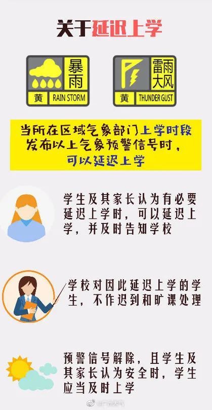
Students based on local early warning
Can delay school
According to the Guangzhou Meteorological Observatory at 6:30: At present, there is a continuous precipitation in our city. It is expected that at the peak of work at 7-9 today, there will be heavy rain in the urban area of Guangzhou, and the temperature is 26-28 ° C. Coinciding with the peak period of work on Monday, please plan the driving route reasonably and drive carefully.

Guangdong specific weather forecast:
On the 4th, there were some heavy rainstorms in western Guangdong, Pearl River Delta, Qingyuan, and Shaoguan. There were local heavy rains in Dongdong City and County.
On the 5th, some cities and counties in Qingyuan, Shaoguan and Pearl River Delta had some heavy rainstorms, and there were some heavy rainstorms in the rest of the cities and counties.
On the 6th, there were local heavy rain in Shaoguan and Qingyuan, and there were local heavy rain in the rest of the cities and counties.
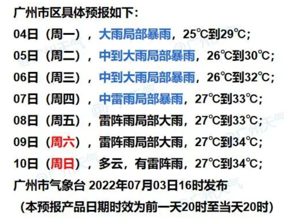
Guangzhou specific weather forecast

After the rain,
Finally it was a lot cold,
But next
High -temperature "steamer mode" will turn on
Source: Guangzhou Daily Comprehensive Guangdong Weather, Guangzhou Weather, China Meteorological News Agency, Xinhua News Agency,@People's Daily
Source: Guangzhou Daily
- END -
From tomorrow, the 8 bus lines in Xining will be adjusted

In order to ensure the construction of the rainwater pipe network on the South and...
People who are good at communication in the workplace have avoided these 7 aspects, and they have benefited early

Leaders arrange work. Don't say that I can't do it directly, or think it is simple...