Typhoon Siaba landed in Guangdong today!Typhoon path Real time release system Hainan encounters heavy rain, stagnant water submerged vehicles, Typhoon "Avey" this year
Author:China Well -off Time:2022.07.03
Typhoon No. 4 "Avery" generated
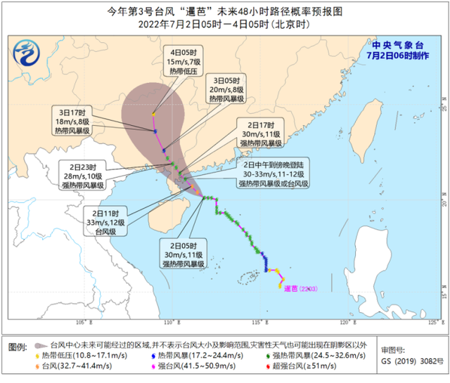
Yesterday, Typhoon Siaba, No. 3 this year, was enhanced to a strong tropical storm level. It approached South my country in China. It is expected to land on the coast of the area from Yangjiang, Guangdong to the Qionghai area of Hainan Island today. typhoon.
At the same time, Typhoon "Avey" this year was generated on the southern ocean of the Philippines with a intensity of tropical storms.
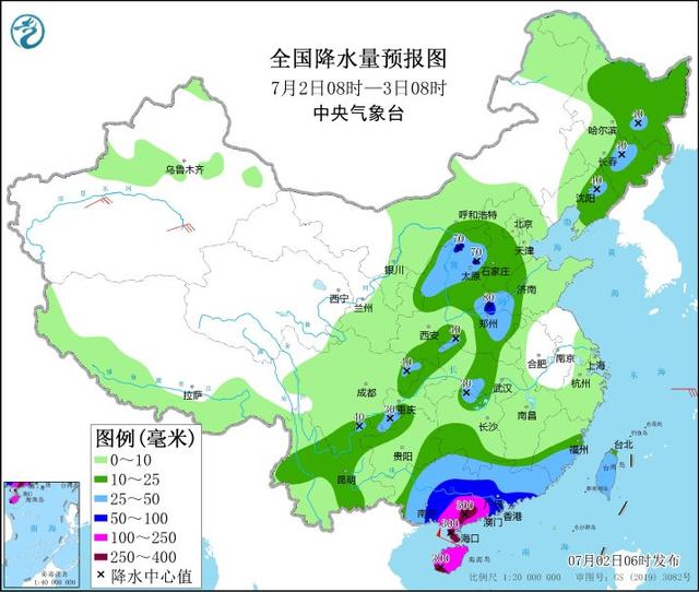
From July 2nd to 3rd, affected by the typhoon "Siaba" and its peripheral circulation, there will be greater storms in South China and its southern waters. There are heavy rain or heavy rain in the region. On the 4th to 6th, due to the maintenance of the low-voltage circulation system, there were heavy rains in parts of Guangxi, eastern Guizhou, Hunan, Hubei and other places, and heavy rainstorms.
"Siam" will land in Guangdong today
The Central Meteorological Observatory issued a typhoon orange warning and heavy rain yellow warning at the same time this morning: It is expected that Typhoon Siaba No. 3 this year will land on the coast of Yangjiang from Yangjiang, Guangdong to Leizhou. At the time of landing, the intensity is a strong tropical storm or typhoon grade (level 11-12, 30 to 33 meters/s). It is expected that before and after the landing of "Siaba", it will bring continuous strong wind and heavy rain to Hainan Island, Guangdong, Guangxi and other places. After landing, it will remain above the tropical storm level for about 24 hours. The above -mentioned regions in South China need to be alert to extreme continuous heavy rainfall.
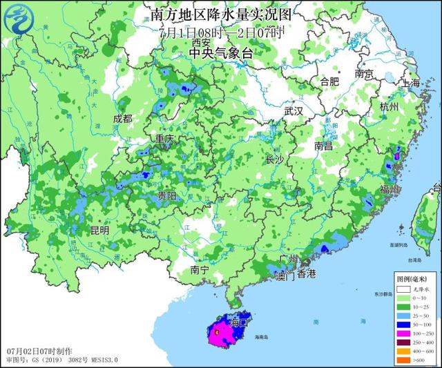
Yesterday, affected by the periphery of the "Siam", heavy rain appeared in Hainan Island, the coast of southern Guangdong, and the eastern part of Fujian. There are heavy rainfall in Ningde, Fujian, among them, the largest rainfall in Changjiang, Hainan, 400 to 455 mm; 7-9 gusts on the coast of Guangdong, the coast of Hainan Island, and 10-11 areas.
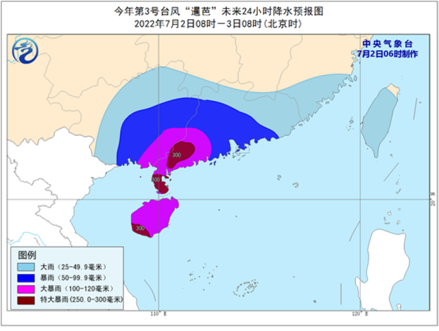
It is expected that in the next 24 hours, due to the influence of "Siam", there will There are heavy rainstorms (250-300 mm) in the southwestern part of Guangdong, Hainan Island and other localities.
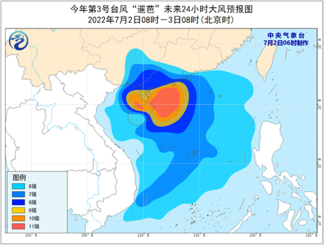
At the same time, the South China Sea, the coast of the western part of Guangdong, the majority of Hainan Island, the southeast coast of Guangxi, the waters near the Xisha and the Zhongsha Islands, the Beibu Gulf and the Qiongzhou Strait will have 6-8 large winds, and some waters or regions will have 9 to 10 winds Grade, the wind power of the nearby waters or regions passed by the Typhoon Center can reach level 11-12, and the gusts are 13-15 levels.
Meteorological experts remind that the typhoon "Siaba" wind and rain affects the area over the area of the "Dragon Boat Water" in South China this year, and the risk of disaster is high. It is necessary to pay attention to preventing the rainfors, geological disasters, floods of small and medium rivers, and urban and rural waterlogging caused by heavy rainfall. Waiting for disaster.
In addition, from July 2nd to 5th, there was a heavy rain in Sichuan Basin, Shaanxi, Shanxi, Beijing -Tianjin -Hebei, Henan, Shandong, and Northeast China. There were heavy rain in Shanxi, Beijing -Tianjin -Hebei, Henan and other places. Among them, today and night today, the east and south of the Sichuan Basin, northern Shaanxi, central Shanxi, northern Henan, northern Liaoning, central Jilin, southern Heilongjiang, southern Hubei, northern Hunan and south and other places.
Hainan encounters heavy rain to flood the vehicle
On the evening of July 1, due to the typhoon "Siaba", some parts of Hainan suffered heavy rainfall. The vehicles on the highway were passing through double flash slowdown, and the roads in some areas were drowned by water.
According to the relevant provisions of the "Hainan Province Flood Control and Windsight and Drought Prevention Emergency Plan", Hainan Province's Flood Control, Wind and Drought Prevention Commander Division decided to increase the flood control and windproof level III emergency response to the flood prevention and wind control level Ⅱ emergency response at 22:00 on July 1, 2022 Essence All units are requested to implement the responsibilities of the division of responsibilities in accordance with the "Hainan Flood Control and Wind and Drought Prevention Emergency Plan" and its supporting manuals and its supporting manuals and "Hainan Province's Flood Control and Wind -controlled Drought Prevention General Headquarters".
(Tuyuan Network China Xiaokang.com Comprehensive Central Meteorological Channel, Nanhai.com)
- END -
The first case in the southwest!From "artificial heart" to heart transplantation

On July 6, after a routine review after the operation, the patient Luo would soon ...
Construct a new pattern of "one nuclear and multi -pole" to develop a new pattern of Wenzhou International Cloud Software Valley officially opened
Create Wenzhou and build a characteristic city in China. On July 15, Wenzhou International Cloud Software Valley Garden.The core area of Wenzhou International Cloud Software Valley is located in t...