Rolling | "Siaba" approaches western Guangdong, the Pearl River Defense Federation has lifted the emergency response of flood prevention and typhoon to the level III
Author:Yangcheng Evening News Yangche Time:2022.07.02
Typhoon Siaba No. 3 this year was generated on June 30. On July 1st, the typhoon warning signal has been hung in the coast of Guangdong on July 1. Landing in the western coastal areas reminds all parts of Guangdong to take typhoon defense measures as soon as possible.
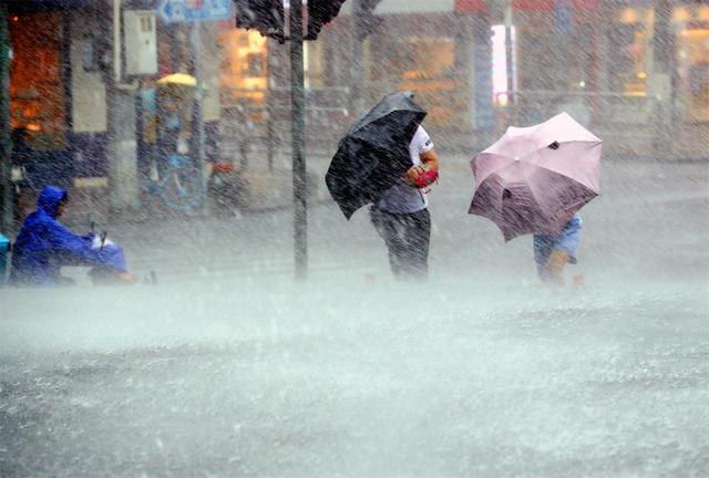
Xinhua News Agency information map
Hong Kong -Zhuhai -Macao Bridge shuttle bus pause service
At 20:25 on July 1, information from the Hong Kong -Zhuhai -Macao Bridge shuttle bus showed that due to the influence of Typhoon Siaba, the Hong Kong -Zhuhai -Macao Bridge shuttle bus was suspended and the restoration time would be notified separately. Passengers who have purchased tickets for the shutdown class can go through the refund procedures for free. (Yangcheng Evening News all -media reporter Wang Danyang)
Guangzhou Maritime Safety Administration launched a Class III Taiwan defense response
Affected by typhoons, Guangzhou Port currently has 6-9 gusts, and thunderstorm weather is obvious. It is expected that gusts will be maintained or further increased. The largest gust of Guangzhou Port can reach level 8-10. The Guangzhou Maritime Search and Rescue Center has launched a high -level cyclone III response at 10:00 on July 1.
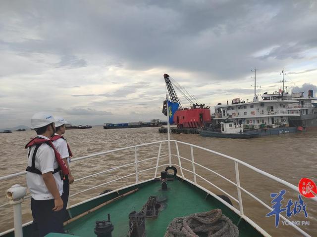
The Guangzhou Maritime Department reminds the crew: Please pay close attention to the typhoon dynamics, strengthen the on -duty look, take measures to prevent Taiwan, stay away from the typhoon to affect the area, and choose a safe water to avoid wind. In the case of emergency, please call the water in the water for help "12395". (Yangcheng Evening News reporter Shen Zhao correspondent Cao Yuanyan Zeng Lulong Fan Tianyou)
The Pearl River Defense President will increase the emergency response of flood prevention and typhoon to level III
On July 1, the reporter learned from the Pearl River Water Conservancy Committee of the Ministry of Water Resources (hereinafter referred to as the "Pearl River Committee") that due to the influence of the typhoon "Siaba", the Pearl River Basin will have a heavy rainfall process from east to west. The risk of floods above the high -police officers in the small and medium -sized rivers is greater. According to the situation of typhoons and rainfall defense, the Pearl River Defense General decided to increase the emergency response of flood prevention and typhoon prevention to the level III at 18:00 on July 1, and the Pearl River Commission simultaneously increased the response of water and drought disaster defense to level III.
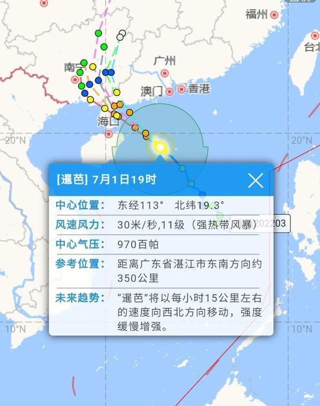
As of 19:00 on July 1, the center of the typhoon "Siaba" was about 350 kilometers from the southeast of Zhanjiang City, Guangdong Province, and the largest wind of the largest wind near the center was 11 (30 meters/second). Move in the northwest, and the intensity is slowly enhanced. It will land on the coast of the western part of Hainan on the afternoon of July 2 to the east of Hainan Island. (Yangcheng Evening News all -media reporter Xu Zhang Chao correspondent Wu Yirong)
Qiongzhou Strait Washing Disasement may last for more than 36 hours
Not necessary, please do not go to the Qiongzhou Strait for the time being. Affected by the typhoon "Siaba", the Qiongzhou Strait ferry has been suspended from the board at 8 am on July 1. In the evening of the day, information from the Guangdong Provincial Department of Transportation shows that the suspension of the Qiongzhou Strait ferry is expected to last for more than 36 hours. Please go to the vehicle in the direction of Hainan, try to adjust the itinerary as much as possible, and do not go for the time being. (Yangcheng Evening News all -media reporter Wang Danyang Correspondent Yue Communication Comprehensive)
Guangdong Water Conservancy Starting Flood Control Class IV emergency response
On July 1, the reporter learned from the Guangdong Provincial Department of Water Conservancy that the typhoon "Siaba" will move north to west at a speed of 15-20 kilometers, tending to the western sea surface and intensity of the western part of Guangdong Province. Typhoon grade (level 12), on the 2nd, landed in the coastal areas between Jiangmen and Zhanjiang during the day. The Guangdong Provincial Department of Water Conservancy launched a level IV emergency response at 9 o'clock on July 1, and the typhoon "Siaba" will have a significant impact on Guangdong.
"Siam" has strong rainfall ability, and you need to be alert to extreme rainstorms
Due to the seasonal Feng Shui vapor transportation, the "Siaba" has a more prominent rainfall ability than wind. Min Yuqiu, a meteorological analyst of China Weather Network, said that South China will have a rainfall area of heavy rain and above. The land, that is, Hainan, Guangdong, Guangxi and other places will undertake the most violent rainfall. Hainan and Guangdong's heavy rains are mainly concentrated from July 1st to 3rd, and the heavy rainfall in Guangxi has continued from July 2 to the 6th. In addition, the rain and advantages of Guizhou, Yunnan and other places are also relatively strong.
Why is the "Siaba" so strong? According to Min Yuqiu's analysis, it is mainly because of the support of the monsoon and the rotation after landing. "Siaba" is far from the subtropical high pressure and lacks a strong guide atmosphere. After landing, the "clip" is in the middle of the high -voltage and subtropical high pressure in the mainland. Long -term staying in Guangxi.
At present, it is the strongest period of the Southwest monsoon. After the "Siam" landed, its circular system is under a large amount of monsoon vapor, and it may bring extreme heavy rainfall to Guangxi in the future.
The typhoon process has a large amount of rainfall and has certain extremes. Min Yuqiu said that Wanning, Tunchang, Lizhou, Qiongzhong, Wuzhishan, Chengmai, Xu Wen, Leizhou and other stations may even approach or break the extreme value of precipitation in early July. (China Weather Network)
The typhoon blue police officer in many districts in Guangzhou is expected to be obvious in the next 24 hours.
At 15:13 on July 1, the Guangzhou Meteorological Observatory upgraded the typhoon white warning signal of Yuexiu and Tianhe to a typhoon blue warning signal. As of 15:25, Guangzhou Yuexiu, Tianhe, Panyu, Nansha and other districts have issued typhoon blue warning signals, except for other districts outside the Conghua District, a typhoon warning signal has been issued. Guangzhou Meteorological Observatory stated that Haizhu, Liwan, Huangpu and other districts will also upgrade typhoon blue warning signals in the future.
According to the observation of the Guangzhou Meteorological Observatory, Typhoon Siaba (strong tropical storm level) this year at 14:00 on July 1st is located on the northwest of the South China Sea in the south of Guangzhou (191 degrees north latitude, 113.2 east longitude east longitude, 113.2 east longitude Degree), the maximum wind near the center is 30 meters/s (level 11), and the lowest air pressure in the center is 970 hundred Pache. It is expected that "Siaba" will move northwest at a speed of 15 to 20 kilometers per hour, and the intensity will be gradually enhanced. It will land in the coastal areas between Yangjiang and Xuwen on July 2.
The Guangzhou Meteorological Observatory predicts that the storms in Guangzhou will become obvious in the next 24 hours, and the thunderstorm weather will become obvious from the afternoon of July 1. It is expected that from July 2 to 3, there will be local heavy rain in Guangzhou. On July 4, there was a local heavy rain in Guangzhou.
As of 15:00 on July 1st, the central and southern parts of Guangzhou have recorded levels 6 to 8 gusts, and the Hong Kong areas will have 6-9 gusts. It is expected that the gusts of land and port areas in Guangzhou will be maintained or further increased. Level 8 ~ 10. (Yangcheng Evening News all -media reporter Liang Yantao)
All routes of Guangzhou Water Bus Suse
On July 1, the Guangzhou Public Transport Group Passenger Rotor Company released the news that due to the influence of Typhoon 202203 "Siaba" tropical storm, the Typhoon No. 2 Fengqiu in the No. 4 area of the Guangzhou Port area. All the docks and routes under the Guangzhou Public Transport Group Passenger Runs are suspended as regulations. After the wind ball is lifted, it will arrange to restore flights. (Yangcheng Evening News all -media reporter Yan Yiwen)
Maoming: Some primary and secondary schools and kindergartens are suspended
The reporter learned from the Maoming Education Bureau that the "Notice of Maoming Education Bureau on School Study Course" was based on the requirements of the Maoming City Education Bureau. Affected by the typhoon "Siaba", the Maoming Meteorological Observatory issued a typhoon yellow warning signal at 9:00 am on July 1. Maoming, Binhai New District, Binhai New District, High -tech Zone, and Education Bureau directly under the school and kindergarten (including the People's Office) immediately stopped classes.
The Maoming Education Bureau requires schools in various places to do a good job in the safety management of students, strictly implement the leadership leadership system, 24 -hour duty system and information reporting system. (CCTV News)
"Siaba" may be attacked in western Guangdong tomorrow
Typhoon Siaba, which has been strengthened to the level of strong tropical storm, may continue to strengthen and tend to the sea surface of western Guangdong. The meteorological department predicts that "Siaba" may be attacked in western Guangdong on July 2 and landed in the coastal areas of western Guangdong, reminding all parts of Guangdong to take typhoon defense measures as soon as possible.
At 11:00 on July 1st, "Siam" and the east of the Philippine low -pressure satellite image
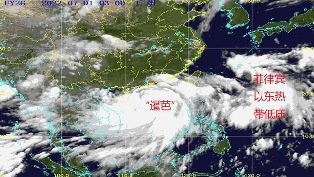
Early warning of typhoon in many places in Guangdong
According to the Central Meteorological Observation, at 11:00 on July 1, the typhoon "Siaba" is located on the South China Sea about 435 kilometers from the southeast of Zhanjiang, Guangdong. Essence
Central Meteorological Observatory's intensity and path forecast for "Siaba" at 12:00 on July 1
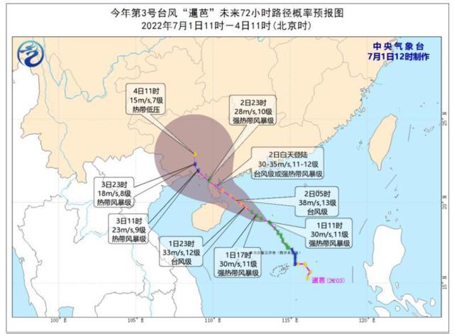
The Guangdong Meteorological Observatory is expected on the morning of July 1 that "Siaba" will move north to west at a speed of 15 to 20 kilometers, tending to the western sea surface, and the intensity will continue to strengthen. Level 12).
Guangdong Meteorological Observatory's path to "Siaba" on the morning of July 1
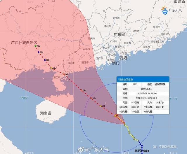
According to the Central Meteorological Observatory, it is expected that on the morning of July 1st, "Siaba" will land on the coast of the Yangjiang to Qionghai, Hainan to Qionghai, Hainan on July 2nd. Tropical storm (level 11-12, 30-35 meters/s); the Guangdong Meteorological Observatory predicts that "Siaba" will attack western Guangdong on July 2, and it is likely to be in the day on July 2nd. The coastal areas from Jiangmen to Zhanjiang landed.
Affected by the "Siaba" is about to be positively attacked, Guangdong continued to upgrade the typhoon warning in many places. As of 12:20 on July 1st, a typhoon warning signal has issued a typhoon warning signal from Chaozhou to the west of Zhanjiang in the east to the west of Zhanjiang. Among them, the yellow warning signals of typhoons from Jiangmen to the west of Zhanjiang in the east are generally issued. In Guangzhou, a typhoon warning was issued in all districts outside the Conghua District, of which a typhoon blue warning was issued in Nansha District.
At 12:20 on July 1st, the Cantonese Typhoon Early Warning was released. Screenshot of the official website of Guangzhou Meteorological Observatory
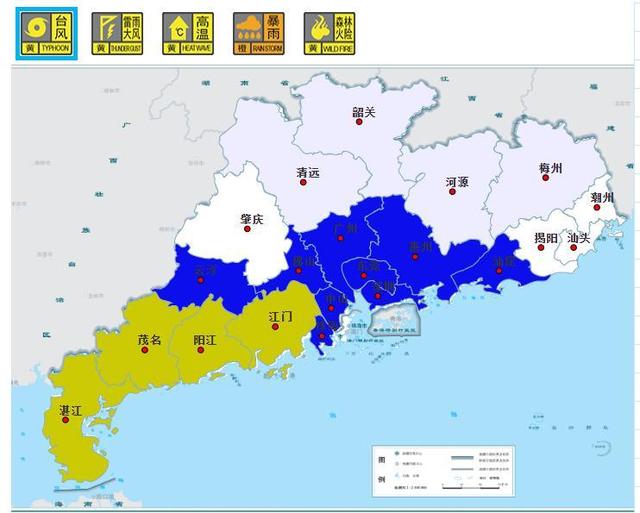
The Guangdong Meteorological Observatory is expected on the morning of July 1 that with the approaching of "Siaba", its impact on Guangdong will gradually extend from the sea to land. It is expected that from July 1st to 2nd, the northwest of the South China Sea, the sea surface of the west of Guangdong, and Qiongzhou in Qiongzhou Straits and Beibu Gulf sea level 6 to level 6 to 8 rotation wind rotation 8 to 10 and level 12 gusts. Among them, the nearby area of the Typhoon Center passes by level 10 to 12, and level 13 to 14.
【remind】
The Guangdong Provincial Meteorological Bureau reminded on the morning of July 1 that the typhoon "Siaba" approached the coast of Guangdong, and may be strengthened to the typhoon level (about 12) in the offshore (about 12), which will bring heavy winds and heavy rain to Guangdong. Defense work.
It is recommended that overseas ships and maritime operators return to Hong Kong to avoid wind in time; island tourism and water projects should be suspended in a timely manner. The coastal cities and counties of Guangdong need to pay attention to disasters such as factory work sheds, temporary structures, outdoor billboards, and trees collapse caused by the short -term wind.
All parts of Guangdong need to defend the stagnation of urban and rural floods, floods, mudslides, and landslides caused by water floods.
Due to the tropical disturbance in the east of the Philippines, it has been strengthened to a tropical low pressure on the morning of July 1st. At present, the South China Sea and the Northwest Pacific have a "double -rotation" state. Affecting the path and strength of the later period of "Siaba", the Meteorological Department of the Guangdong Province will pay close attention. (Yangcheng Evening News all -media reporter Liang Yantao Correspondent Liang Qiaqian Xu Qingzhou) Dongguan starts a typhoon anti -anti -level emergency response
The reporter learned from the Dongguan Flood Control and Drought Control and Wind and Wind and Wind and Wind and Wind and Wind and Wind and Wind and Wind and Wind and Wind and Wind and Wind and Wind and Wind and Wind and Wind and Wind and Wind and Wind and Wind and Wind and Wind and Wind and Wind and Wind and Wind and Wind and Wind and Wind and Wind and Wind and wind prevention headquarters. On the South China Sea of 524 kilometers, the maximum wind near the center is 10 (25 meters/s).
Dongguan has issued a typhoon blue warning signal. According to the "Dongguan City Flood Control, Drought Prevention and Wind -proof Emergency Emergency Plan", it was discussed and judged by the meeting. Please strengthen duty and leaders in the town and streets (parks) and relevant units according to the actual situation, start emergency response to the headquarters of the region in a timely manner, and earnestly do various defensive rescue work. (Yangcheng Evening News all -media reporter Wang Lei)
Foshan launched a typhoon anti -anti -level emergency response
The reporter learned from the Foshan Three Defense Office that at 15:00 on July 1, Foshan launched a typhoon anti -anti -level emergency response, and the typhoon blue warning signals in each district had taken effect.
It is reported that Typhoon Siaba (strong tropical storm) this year is at 14:00 on the South China Sea about 380 kilometers from the southeast of Zhanjiang City, Guangdong Province, and the largest wind is 11 (30 meters/s) near the center. It is expected that it will move northwest at a speed of about 20 kilometers, and the strength will be slowly strengthened. Typhoon blue warning signals in various districts in Foshan City have taken effect. According to the "Flood Control Drought Prevention and Wind -proof Emergency Prevention Plan", the Municipal Third Defense Headquarters launched a typhoon IV emergency response at 15:00 on July 1. Relevant departments in all districts in the city shall timely start emergency response of the headquarters of the region in a timely manner according to the actual situation, and do a good job of various defense work. (Yangcheng Evening News All -Media Reporter Liang Zhengjie Intern Xun Yin Yin)
Foshan will have the risk of tornado in the next 4 days
On July 1, the Foshan Meteorological Observatory held a press conference to report on the impact of the typhoon "Siaba" and the relevant situation of the weak tornado in the South China Sea on June 30. Typhoon "Siaba" has been strengthened to a strong tropical storm at 23:00 on June 30. It is expected to land in the coastal areas between Yangjiang and Zhanjiang during the day on the 2nd. At present, the white warning signals of typhoons in various districts in Foshan have taken effect, and may be upgraded to typhoon blue warning signals on the 1st.
"Siaba" is coming, and it is expected to have a few days of storms and rainfall in Foshan. Foshan Meteorological Observatory is waiting.
At the meeting, Li Cailing, deputy director of the Foshan Meteorological Observatory, was not reported to Foshan's influence on Foshan's weak tornado in the South China Sea and the upcoming typhoon "Siaba". It is reported that around 16:47 on June 30, a weak tornado occurred near Danqiu Village, Yanfeng Community, Shishan Town, Nanhai District, Foshan City, and there were no casualties reports. The tornado scale is small and the history of life is short. It is the first level of the national standard (EF0). It will quickly weaken and dissipate when it is developed. The duration of the road is about 50 meters and the width is about 20 meters.

This is the second weak tornado that occurred in Foshan this month. Li Cailing said that Foshan is a strong convection area, and the strong convection is mainly concentrated in March to September, and the wind disaster is more serious. According to statistics, the average annual tornado of Foshan has an average of 4.3 provinces in the province. From 2006 to 2021, there were 23 tornado appeared in Foshan, mostly in the northern and southern parts of Sanshui.
Foshan Meteorological Observatory
The press conference also introduced the influence of the upcoming typhoon "Siaba". It is reported that the typhoon "Siaba" has been strengthened to a strong tropical storm at 23:00 on June 30. The maximum wind power near the center is 10 (25 meters/s). The intensity continues to strengthen, and it is likely to land in the coastal areas between Yangjiang and Zhanjiang during the day. It is expected to be closest to Foshan on the afternoon of the 2nd, about 280 kilometers. At present, the typhoon white warning signals in various districts in Foshan have taken effect, and may be upgraded to a typhoon blue warning signal on the 1st.
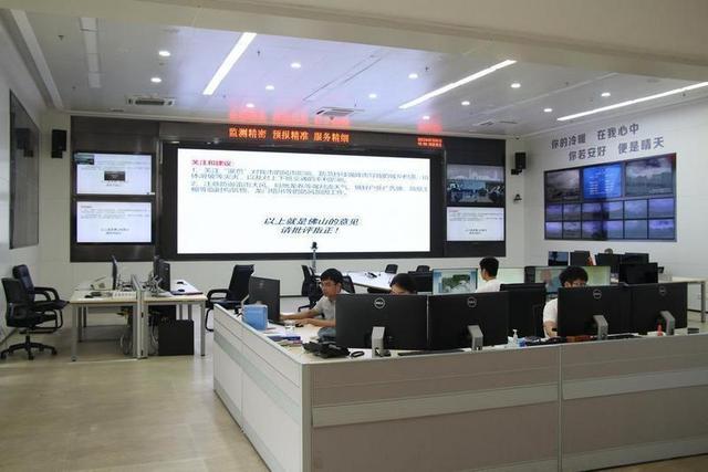
According to the Foshan Meteorological Observatory, on July 1, Foshan will have strong thunderstorms, accompanied by short-term heavy precipitation, Level 8 thunderstorms and other strong convective weather; on the 2-4, with the development and further approach of "Siaba", There are heavy rain, the average wind gradually increases to level 4-6, and the gusts are about 9th; there will still be medium to heavy rain on the 5th to 7th; the risk of tornado will occur in the next 4 days. Preliminary estimates that the cumulative rainfall from July 1st to 4th is 100-200 millimeters and local 250 mm.
Li Ca Ling said that "Siaba" is coming, and it is expected to have a few days of storms and rainfall in Foshan. It is necessary to prevent disasters such as urban and rural waterlogging and landslides caused by continuous rainfall. Thunderstorm wind and local tornado and other strong convective weather, relevant departments do the windproof and reinforcement work of temporary structures such as outdoor billboards, simple sheds, etc. (Yangcheng Evening News all media reporter Wu Yong)
Zhanjiang: On the afternoon of July 1st, the city's primary and secondary schools, kindergartens, and off -campus training institutions were suspended
On the morning of July 1, the Zhanjiang Meteorological Department issued a typhoon yellow warning signal. In order to ensure the safety of teachers and students, the Zhanjiang Education Bureau was judged by the Meteorological Department and decided to suspend classes in the city of primary and secondary schools, kindergartens, and off -campus training institutions on the afternoon of July 1. The Zhanjiang Education Bureau requires that schools in various places should implement the suspension measures in accordance with relevant regulations, while compacting the responsibilities of work, strictly organize measures to prevent the station, pay close attention to the development of typhoons, and do their best to do well. Release disaster weather early warning information to guide teachers and students and parents to actively prevent disaster prevention and avoidance. In addition, we must implement the 24 -hour duty -on duty system, strengthen communication with meteorological and emergency departments, realize the risk of disaster in real time, start emergency response in a timely manner, keep an eye on the changes in the rain love, effectively improve the accuracy, timelyness and time of emergency command command Effectiveness to ensure the safety of teachers and students' lives and property.
"Siaba" will seriously affect Zhanjiang City. From the 2nd to 4th, Zhanjiang City will have a heavy rainfall from a heavy rainfall. The cumulative rainfall of the process is 200 ~ 280 mm, and the local area is more than 400 mm. Level 12, land wind power can reach level 10-12. At present, the city's typhoon yellow warning signals are taking effect, and all the sea areas have changed from now on the typhoon signal No. 3. (Yangcheng Evening News all -media reporter Yuan Zengwei)
Guangdong windproof emergency response was increased to level III level
Given that the wind power of the Typhoon "Siaba" has reached 10 levels, it may be positive to Guangdong in the next 48 hours. According to the relevant provisions of the "Guangdong Province Flood Control, Drought Prevention and Wind and Frozen Emergency Plan", the Guangdong Provincial Flood Control and Drought Control and Wind and Wind and Wind and Wind -proof Headquarters decided to decide in July in July At 12 o'clock on the 1st, the Class IV emergency response was promoted to the windshield III emergency response.
At 8 o'clock on July 1, Typhoon Siaba (strong tropical storm) was located on the sea about 490 kilometers southeast of Zhanjiang City. It is expected that it will move northwest at a speed of 15 to 20 kilometers. Continue to strengthen, the strongest can reach the typhoon level, and it is likely to land in the coastal areas between Jiangmen to Zhanjiang during the day on the 2nd.
All localities and departments are requested to strengthen business judgments, timely start emergency response or adjust the level of emergency response, further do a good job of typhoons and the second disaster defense work, go all out to ensure the safety of the lives and property of the people, and minimize disaster losses. (Yangcheng Evening News all -media reporter Fu Yi Correspondent Yue Yingxuan)
Wave Orange Police: There will be large waves to huge waves in the near -shore waters of Guangdong
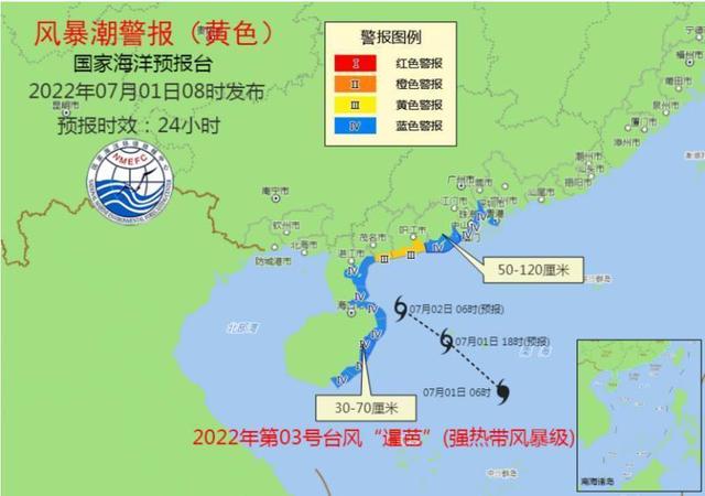
The reporter learned from the Ministry of Natural Resources on July 1 that due to the influence of Typhoon Siaba (strong tropical storm) this year, the National Oceanic Forecasting Channel released the orange alert and storm trendy yellow alert based on the "Emergency Plan" of the Marine Disaster. Essence
According to the Central Meteorological Observatory, the center of Typhoon "Siaba" No. 3 this year is about 250 kilometers northeast of Sansha City (Xisha Yongxing Island) at 8 o'clock today (July 1). It is expected that "Siaba" will move northwest at a speed of 15-20 kilometers per hour, and the intensity will increase slowly.
The specific forecast is as follows:
In terms of storm waves, due to the influence of Typhoon Siaba (strong tropical storm) this year, it is expected that from July 1st to noon from the morning to the 2nd, 50 to 120 cm of storms from the east coast of the Pearl River Peninsula will appear. Increasing water, 30 to 70 cm of storms in the northeast coast of Hainan Island will increase water.
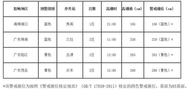
The Guangdong Beijin and Shuidong Tide Station on the shore section will appear at noon on the 2nd to reach the climax of the local yellow warning tide. Three stove tide stations will appear to reach the climax of the local blue alert tide on the morning of the 2nd. The storm tide warning level of Yangjiang City and Maoming City, Guangdong Province is yellow. The storm warning level of Haikou City and Zhuhai City, Guangdong Province is blue.
The coastal governments and relevant departments are requested to do a good job of emergency preparations for defensive storm tide; relevant units related to the sea -related units take positive and effective measures to organize fishing boats, farming and fishing row, farm, etc. Facilities, prepare moisture -proof.
In terms of waves, due to the influence of Typhoon Siaba (strong tropical storm) this year, it is expected that from noon to noon from July 1st to noon, 4 to 6.5 meters of waves will appear in the northern part of the South China Sea to the crazy wave area, and the offshore will appear. Sea wave early warning level is yellow; large waves from 3 to 5 meters will appear in the near -shore waters of Guangdong. Sea wave warning level is yellow.
Please pay attention to safety in the above -mentioned sea areas, and relevant units of the coastal coastal to take anti -wave avoidance measures in advance.
Jiangmen: Taishan City Stop Course
Jiangmen Teshan City Meteorological Bureau upgraded the typhoon white warning signal at 11:28 on June 30th to blue. In accordance with the "Taishan City Flood Control, Drought Prevention and Windsight and Frozen Emergency Plan", the Municipal Third Protection Headquarters decided to launch a Class IV emergency response at 12:00 on June 30. In order to ensure the safety of teachers and students in Taishan City, the Municipal Three Defense Headquarters decided:
From July 1st, the city's primary and secondary schools and kindergartens have been suspended, and off -campus training institutions have been suspended. The original research and test tests of the relevant grade period were suspended.Based on the actual situation, each school must make a good job of working to leave and stay in school, and organize leaving school before 10:00 am on July 1; at the same time, we must do a good job in the management and living security of students staying in the school to fully communicate with parents.Properly arranged shuttle delivery to ensure that students are safe and secure.2. suspend the work of freshmen in Xinning Elementary School on July 2, and the review of the data of the Student District of Xinning Middle School on July 2-3, and the specific implementation time will be notified separately.
3. During the suspension of the class, parents must earnestly fulfill their care of their children, closely cooperate with the school to do a good job of safety education to ensure students' safety.(Published by Taishan)
Source | Yangcheng Evening News · Yangcheng School Comprehensive CCTV News, National Ocean Forecasting Station, China Weather Network and other responsible editors | Wu Xiang Liang Zeming Zheng Zongmin
- END -
More than 100 yuan per catty!Remove from West Lake late at night, busy until 3 am, someone in Hangzh

Hangzhou, which gradually became hot, finally felt a little summer, and also made ...
Special: After the Fourteen Loings of Straits Forum, the exchanges on cross -strait exchanges are the great view

The 14th Straits Forum Conference on July 13. Xinhua News Agency reporter Wei Peiq...