Typhoon "Olysu" will enter the near shore of the South China Sea tomorrow. It mainly affects eastern Hainan and southern waters
Author:National Ocean Forecasting Tai Time:2022.09.24

Typhoon
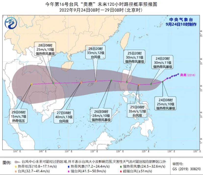
Typhoon No. 16 this year "Olympic" (English name: NORU; Source of the name: South Korea; Name meaning: 狍 今) It was generated on the southern ocean in the Philippines yesterday (23) in the afternoon of yesterday (23rd). Typhoon "Olysu" has been strengthened to a strong tropical storm in the morning (24th) in the morning (24th), and continues to move westward. It is expected that it will pass through the Philippines to Luzon Island, Philippines to enter the South China Sea.

Picture source: Central Meteorological Observatory
Wave message
The National Oceanic Forecast Power released the wave of waves today at 15:00:
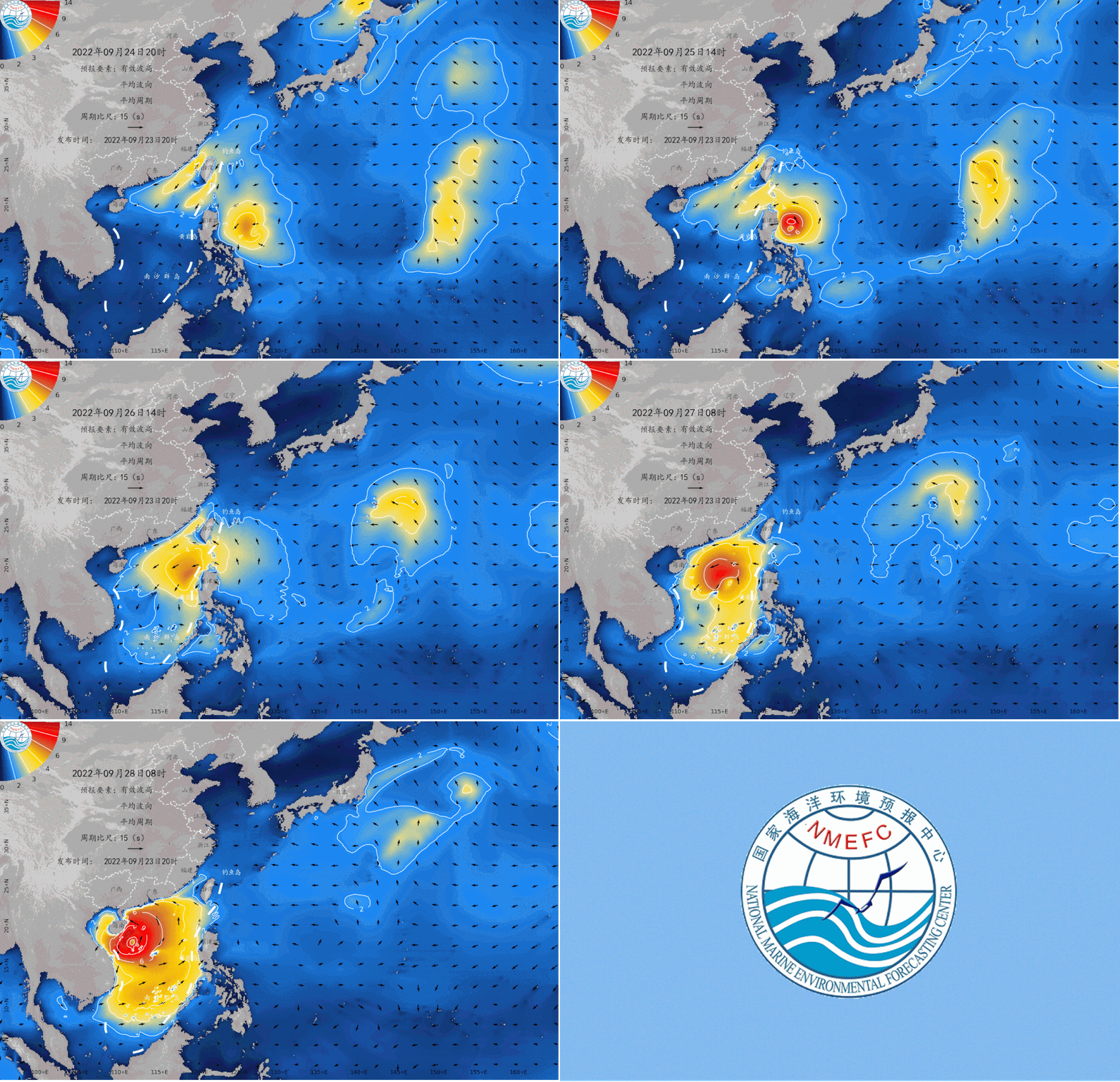
Affected by Typhoon 16 (strong tropical storm) and cold air this year, it is expected that from September 26th to 28th, there will be a process of giant waves and above in the South China Sea. Please pay attention to avoid waves in the above -mentioned waters, and pay attention to the subsequent warning of the waves of Taiwan in time.
In the process of waves, offshore mainly affects the bus strait, South China Sea, and Beibu Gulf. The valid wave high in offshore can reach about 8 meters.
Near -shore mainly affects eastern Hainan and southern Hainan. The valid wave height of the near -shore can reach up to 4 meters. The highest warning level of the near -shore is yellow.
Due to the uncertainty of the typhoon path, please pay attention to the subsequent wave early warning of our center in time.
Let's see the "Ocean Forecast" journal guide

Research on the Risk Evaluation Zone of the Coastal Storm Disaster Risk Evaluation of Huanghua City
Please use the PC terminal download address:
http://www.hyyb.org.cn/magazine/show.aspx?id=3409
Note
Author: Ding Yurong 1 Wang Shibin 2 Liu Shichao 3 Liu Youcai 1 Wang Ping 1
Unit: 1. Hydrological Engineering Geological Examination Institute, Hebei Shijiazhuang 050021;
2. The Fourth Hydrological Engineering Geological Brigade of the Hebei Provincial Land and Mining Bureau, 061000, Cangzhou, Hebei;
3. National Marine Environment Forecast Center, Beijing 100081
Category Number: P731.23
Publishing Year · Volume · Period (page number): 2022 · 39 · Fourth Issue (9-15)
Abstract: Taking the coastal area of Huanghua City as the research object, the ADCIRC model is used to establish a typhoon and temperate storm tide beach numerical model to evaluate the danger of storm waves under different working conditions. Disaster risk assessment and regional research. The results show that: under the influence of the 965 HPA and 955 HPA -level typhoon storm waves and wind storms of 32 m/s and 36 m/s, the coastal towns and towns are damaged to varying degrees, and the risk of temperate storm is greater than that of typhoons. Essence The high -risk zone of Huanghua City is mainly distributed in Nanpaihe Town, Xincun Hui Township and Huanghua Port. The highest risk -up condition is the tide of temperate storm (36 m/s). The area of the storm trend risk zone under this condition is 1 184.54 km2. It is the lowest risk of other townships in Nanpaihe Town, Luqiao Town, Yang Sanmu Hui Township, Zhongjie Friendship Farm and Nanda Port Farm.
Keywords: storm trend disaster; danger; vulnerability; risk assessment; zoning; Huanghua City
Abstract:Taking the coastal area of Huanghua City as the research object, the ADCIRC model is used to establish a typhoon and extratropical storm surge inundation numerical model, and to evaluate the risk of storm surge disaster under different working conditions. Combined with the vulnerability analysis of disaster-bearing body, the risk assessment and zoning research of storm surge disaster is carried out in this paper. The risk assessment results show that under the influence of typhoon storm surge with the level of 965 hPa and 955 hPa and extratropical storm surges with wind speeds of 32 m/s and 36 m/s, coastal towns are damaged to varying degrees, and the risk of extratropical storm surges is greater than that of typhoon storm surges. The high-risk areas in Huanghua City are mainly distributed in Nanpaihe Town, Xincun Hu Ethnic Township, and Huanghu Port. The Working Condition with The Highest Risk is the Dyke Break Cautropical Surge With the level OF 12 m/s angel d 36 m/s. Under that condition, the storm risk area is 1 184.54 km2, of which Huanghua Port and Xincun Hui Ethnic Township have the largest risk area of level I, followed by Nanpaihe Town, Luqiao Town, Yangsanmu Hui Township, Zhongjie Friendship Farm, NANDAGANG FARM, While The Other Townships Have Lower Risk.key Words: Storm Surge Disaster; Risk; Vulnerability; Risk Assessment; Zoning; HuangHuaa City;
Readers can also pass the public account menu bar

"Related Knowledge" sector enters
"Time Catalog" and "Publishing Browse"
Check the detailed journal content
The marine environment forecast in the next two days
Expected tomorrow,
There are light waves of 0.9 to 1.2 meters in the Bohai Sea;
The Yellow Sea has a light wave of 0.5 to 1.1 meters;
There are light waves from 1 to 2.4 meters near the waters near the East China Sea and Diaoyu Islands;
The Taiwan Strait has a large wave area of 2.8 to 3.2 meters;
There are 1.9 to 2.1 meters of Zhonglang District in Taiwan;
There are 2.2 to 2.7 meters in the Bado Strait to Dalang District;
There are 1 to 1.4 meters of light waves to Zhonglang;
Affected by Typhoon No. 16 this year, there are large waves from 2.5 to 4.2 meters in the northern and central parts of the South China Sea;
There are 1.3 to 1.7 meters in the southern part of the South China Sea.
Expected the day after tomorrow,
The Dalang District of the Taiwan Strait is maintained, the wave height is 2.2 to 2.7 meters;
The big wave area of the bus strait has weakened and disappeared;
Affected by Typhoon No. 16 this year, the Dalang District of the northern and central parts of the South China Sea maintained, the waves height were 4 to 6.2 meters. September 24th to 28th northwest Pacific wave numerical forecast
Beautiful island waters sea conditions

Expected tomorrow,
There are large waves of 2.5 ~ 2.6 meters near the waters near Pingtan Island, Dongshan Island, and Huangyan Island. Sandu Island, Meizhou Island, Diaoyu Island, South Australia Island, and Yongxing Island are 2.1 ~ 2.4 meters of Zhonglang. Suitable for traveling by boat;
There are 1.8 to 2 meters near the waters near Jiezhou Island and Yongshu Reef. There are 1.3 ~ 1.7 meters near the waters near the mountains and Wuzhizhou Islands. These islands are more suitable for traveling by boat;
The waters near the other beautiful islands in my country are light waves, with good sea conditions, and they are very suitable for traveling and island.
Beautiful island refers to the following 35 islands:
Juehua Island, Changshan Islands, Bodhi Island, Long Island, Liu Gong Island, Lingshan Island, Qinshan Island, Lianjima, Chongming Island, Shengsi Islands, Sushan Island, Dongji Island, Putuo Mountain, Dachen Island, Yuhuan Island, Dongdong Tou Island, Nanji Island, Laoshan Island, Sandu Island, Pingtan Island, Meizhou Island, Dongshan Island, Diaoyu Island, South Australia Islands, Wanshan Islands, Sichuan Shan Islands, Hailing Island, South Island, Dong Island, Dong Island, Dong Island, Dong Island, Dong Island, Dong Island, Dong Island, Dong Island, Dong Island, Dong Island, Dong Island, Dong Island, Dong Island, Dong Island, Dong Island, Dong Island, Dong Island, Dong Island, Dong Island, Dong Island, Dong Island, Dong Island, Dong Island, Dong Island, Dong Island, Dong Island, Dong Island, Dong Island, Dong Island, Dong Island, Dong Island, Dong Island, Dong Island, Dong Island, Dong Island, Dong Island, Dong Island, Dong Island, Dong Island, Dong Island, Dong Island, Dong Island, Dong Island, Dong Island, Dong Island, Dong Island, Dong Island, Dong Island, Dong Island, East Island, East Island, East Island, Dong Island Dazhou Island, Boundary Island, Wuzhizhou Island, Yongxing Island, Huangyan Island, Yongshu Reef.
More coastal tourism forecasts are all in China's marine forecast
PC can log in to China Ocean Forecast Network http://www.oceanguide.org.cn/indexhome
The mobile terminal can use China Ocean Forecast WeChat Mini Program

Click the picture below

Enter "China Ocean Forecast" WeChat Mini Program
Long press the picture below to identify the QR code

- END -
How to play in the summer vacation?"Big hand holding a small hand" unlock the new model of holidays ~

Colorful summer vacation, happy growth. On July 15th, the Liujiang District Federa...
Director of power supply becomes "net red" revolutionary old district "electricity" Xingnong

Henan Daily Client Reporter Ji Jian Correspondent Zhang Ye Chen Huanhuan Ping Rong...