Cold air continues to force the northern bureau to cool down by 8 ° C or more
Author:Henan Daily Client Time:2022.09.24
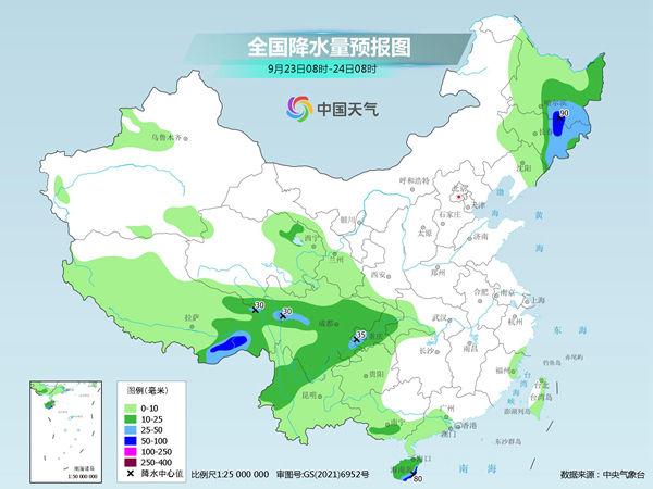
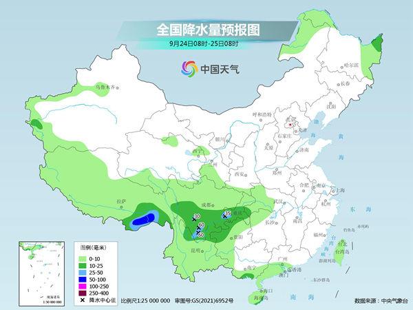
Tomorrow (September 23rd to 24th), cold air continues to affect my country, Huanghuai and other places will fall by 4 ~ 6 ° C, and the local area is above 8 ° C. In terms of precipitation, there are heavy rain in the northeast and parts of the southwest area today, and heavy rain. Tomorrow, rainfall in the northeast will decrease and weaken, and rainfall will continue to rain.
Cold air will continue to force the high temperature in South China on weekends tomorrow
The cold air became active this week. Yesterday, the new cold air began to affect our country. There was a wind cooling in some areas of the Northeast, North China and other places. This morning, the temperature in many places in the north hit a new low in the second half of the year, like Hohhot's minimum temperature dropped to the freezing point, and the chill was prominent.
Tomorrow, cold air continues south to affect my country. The Central Meteorological Observatory predicts that the temperature of Huanghuai, Jianghuai, the northeast of the south and southwestern regions, and the eastern parts of the northeast region will drop by 4 ~ 6 ° C or above. Gust 7 ~ 9. There are 6 ~ 8 winds in the eastern waters of my country, and gusts 9 ~ 10.
After the cooling process, the cold air activity weakened, and most of the temperature in the north gradually rose. Among them, the highest temperature in North China will reach or even exceed 30 ° C at the end of September, and the temperature will be large. The public should pay attention to the weather changes in time, increase or decrease clothes in a timely manner, and beware of colds.
The cold air has been promoted to South China at the end of the crossbow. The south has begun to develop again at high temperatures this weekend. In large cities, high temperatures will appear in Guangzhou, Fuzhou, and Nanning on the 25th. Please pay attention to heatstroke prevention and cooling.
There are still strong rainfall in the southwest and other places.
In terms of precipitation, today, there are strong rainfall in the northeast and southwestern regions, and some areas have medium to heavy rain and heavy rainstorms. Tomorrow rainfall decreases and weakens, and rainfall will continue in the southwest.
Specifically, the Central Meteorological Observatory predicts that today, the southern and eastern part of Heilongjiang, the central and eastern Jilin, eastern Tibet, most of Sichuan, most of Chongqing, northwestern Yunnan, and parts of Hainan Island There are heavy rain (50-90 mm) in northern Jilin and other localities.

Tomorrow, there are heavy rain in the northeast of Heilongjiang, southeast of Tibet, southern Sichuan, northern Yunnan, central and southern Chongqing, northern Guizhou, southeast of Hainan, and heavy rain in southern Sichuan, southeast of Tibet 50-60 mm).

Meteorological experts reminded that due to continuous rainstorm, the possibility of floods and geological disasters in parts of western Sichuan, southeast of Tibet, and other areas of the regions of Sichuan, and geological disasters should be more important to prevent prevention. In some parts of the Northeast, the rain is strong today. Please pay attention to the adverse effects of high rainfall on transportation and agriculture. Jiangnan and other places continue to rain, and various drought resistance measures must be taken.
- END -
"What is the effect of the new warfare, try the online platform 'real knife and real gun"! "

The 73rd Army relies on the new type of chess confrontation system to promote trai...
Watching Xinyang in a good life | Shuicheng Huaxiang's beautiful changes in Xinguang Prefecture, making people envious

Henan Daily Client reporter Hu Dacheng Henan Daily All -Media Reporter Liu Hongbin...