Typhoon "Plum Blossom" affects high temperatures in the south of the Northeast in many places in the south of the south.
Author:Sichuan Observation Time:2022.09.16
Typhoon "Plum Blossoms" will continue north after landing in the coast of Laoshan District, Qingdao City, Shandong Province today (September 16) at 00:00 am. It will bring strong storms to Liaoning, Jilin, Heilongjiang and other places, and heavy rain in some areas in Liaoning. Tomorrow, the influence of "plum blossoms" will weaken. In terms of temperature, the weather in most areas in the central and eastern regions is fine today, and the temperature is higher than the same period of the same year. There will be extensive high temperatures in Hunan, Jiangxi, and Hubei. The cold air coming next week, and the temperature will fall from north to south.
Typhoon "Plum Blossom" Sandao will be ascended to Liaoning around this evening
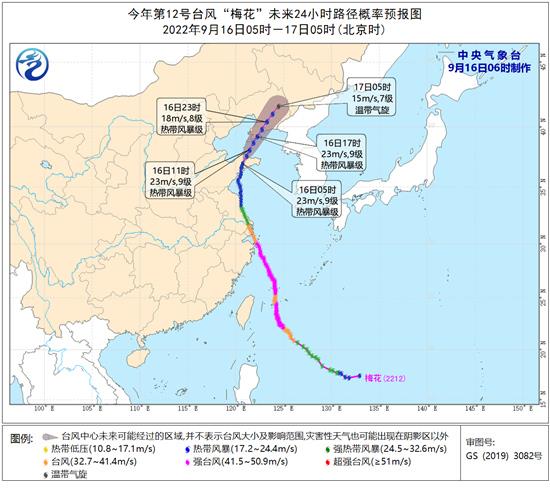
Typhoon No. 12 this year, "Plum Blossom" at 20:30 on the 14th, landed at the coast of Putuo, Zhoushan, Zhoushan, Zhejiang. After landing, the "Plum Blossom" passed through Hangzhou Bay, and landed on the coast of Fengxian in Shanghai around 0:30 am on the 15th. Later, he passed through the eastern coast of Jiangsu from south to north. On the 16th, he landed on the coast of the coast of Laoshan District, Qingdao, Shandong, in a tropical storm on the 16th.

Yesterday, Qingdao, Shandong, encountered heavy rainfall, and the road was serious.
Under the influence of typhoons, Jiangsu, Shandong and other places encountered strong wind and rain. Monitoring shows that from 8:00 yesterday to 6:00 today, large rainstorms in the northeast of Jiangsu, central Shandong, eastern Liaoning, southeastern Jilin, and other areas. ~ 150 mm), Shandong Qingdao and Yantai Bureau Extraordinary Rainstorm (250-353 mm). In addition, 8-9 gusts are also appeared in eastern Jiangsu, Shandong Peninsula and other places, and levels 10-12.
At 5 o'clock today, the "Plum Blossom" center is located in Laiyang, Yantai, Shandong. It is expected that "Plum Blossom" will move north at a speed of 20-25 kilometers per hour. The strength will not change much. In the evening, it will land again in the Liaoning Lushun to the Zhuanghe area (tropical storm level, 18-23 meters/s, level 8-9), and then gradually transgender into temperate cyclones.

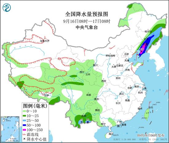
It is expected that today, the impact of the "plum blossoms" will mainly appear in Liaoning, Jilin, Heilongjiang and other places. The Central Meteorological Observatory predicts that there are middle to heavy rain in parts of Liaoning, Middle East Jilin, Southeast Heilongjiang, Southeast Tibet, Southeast Qinghai, Northern Sichuan Plateau, and southeast of Yunnan. Among them There are heavy rain or heavy rain (100 to 160 mm) in part of the ground.

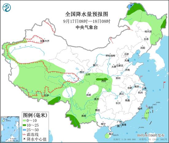
Tomorrow, the influence of "plum blossoms" will weaken. Northeast Inner Mongolia, northwestern Heilongjiang and east, southeast of Tibet, southern Shaanxi, southwestern Yunnan, and southwestern Yunnan, there are heavy rain (25-30 mm).

The meteorological department reminds that the strong winds and rain caused by typhoons in Liaoning, Jilin, Heilongjiang and other places must not affect the operation of the operation and transportation of the city, and do a good job in the defense of floods and geological disasters, floods in small and medium -sized rivers, and urban and rural floods.
Most of the temperature in the central and eastern parts is high in the cold air to cool down the next week
Recently, in addition to the frequent southwestern region of the rain, the temperature in most areas in my country is at a higher level than the same period of the same year. The warmth in the north and Central China is particularly obvious.
It is expected that this day, most of our country will welcomes heating, the temperature of the North China plain will generally exceed 30 ° C, and there will be extensive high temperatures in Hunan, Jiangxi, and Hubei. The South China area will continue to be high in the next few days, such as Fuzhou and Guangzhou's highest temperatures from four days from now on 35 ° C or above.
Beginning on the 18th, a cold air began to affect the north, and then pushed south, which will bring down to the central and eastern regions. After the cooling, the temperature in most parts of the central and eastern regions will turn to normal or low levels of the same year. Especially in the Northeast, the highest temperature on 19-20 will generally be less than 20 ° C, and the lowest temperature will only be one digits. Most of the temperature will refresh a new low after autumn. North China and Huanghuai to Jiangnan will get rid of the hot state, and the highest temperature will drop below 30 ° C at the beginning of next week. The public needs to pay attention to the forecast and pay attention to changes in temperature to avoid colds.
Sichuan Observation (Source: China Weather Network)
- END -
Jinxiang: Standardize the urban environment of the city and order to improve the urban environment

In order to effectively improve the city's city capacity environment and continuou...
Support the "flood prevention umbrella" to build the "anti -epidemic wall" -wen County Emergency Administration Bureau to protect the safety of the people

The situation of the epidemic and the flood disasters is very severe. The Wenxian ...