After the earthquake radar satellite map shows that the Hailou Glacier has a significant deformation, and experts evaluate the possibility of the disaster caused by the ice collapse.
Author:Chuanguan News Time:2022.09.14
Chuanguan News reporter Xu Lisha
On September 5, a magnitude 6.8 earthquake occurred in Luding County. What is the impact of this earthquake? Social concerns.
On September 14, the reporter learned from the National Key Laboratory of Geological Disaster Prevention and Geological Environmental Protection of Chengdu University of Technology that the laboratory's team recently used Professor Li Weile's team to use the Ludong earthquake on August 26 and September 7th. The strength of the Sentinel 1 radar satellite rail lift strength image, based on pixel offset tracking technology, calculated the results of the glacier deformation around the main peak of Gongga Mountain.
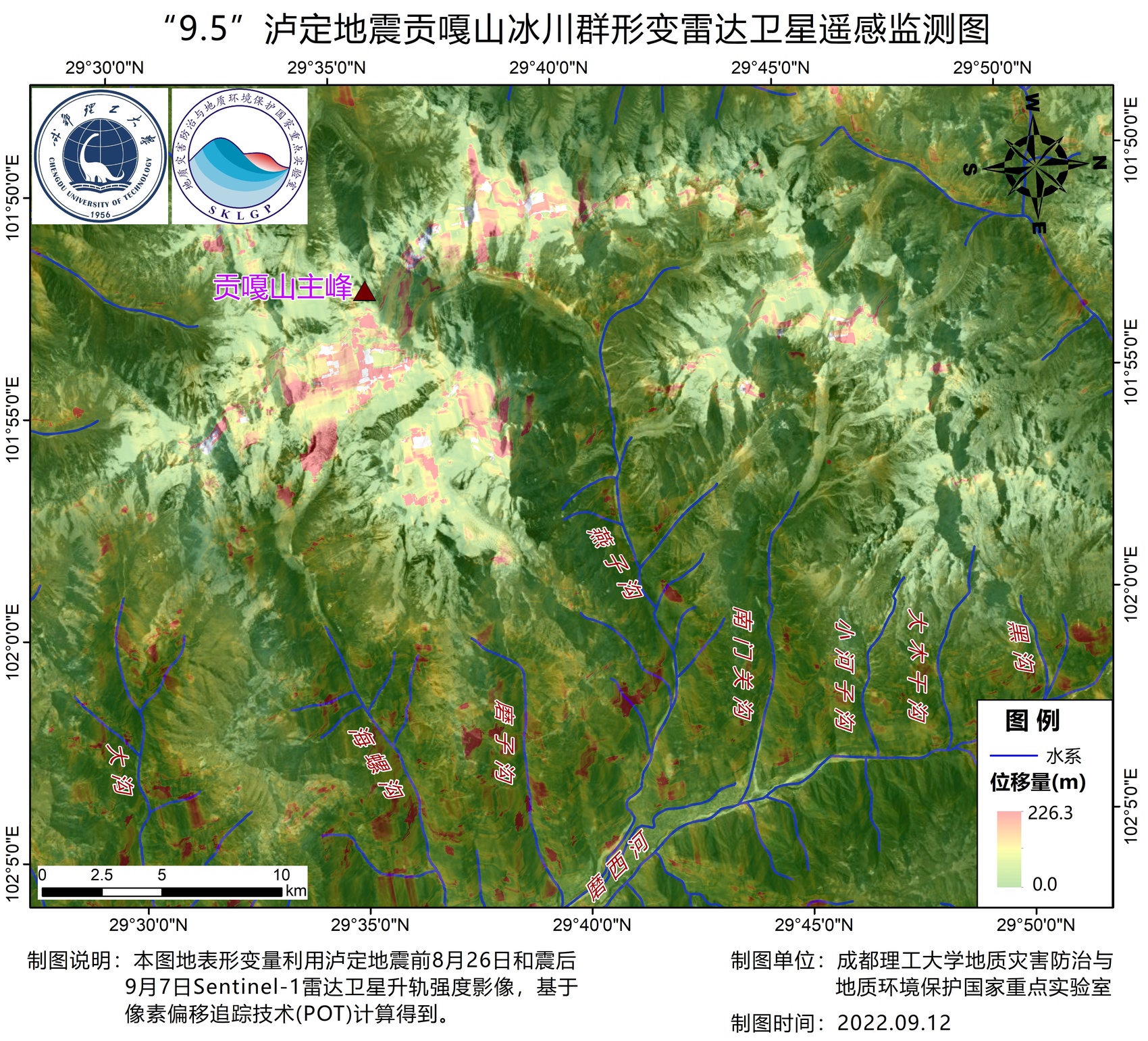
"September 5" Luding Earthquake Gongga Mountain Glacier Group Transformation Radar Satellite Remote Sensing Monitoring Monitoring Li Weile Figures
The results showed that the earthquake caused the glaciers such as Hailugou, Mozigou, Yanzigou, Nanmen Guangou, and the subsequent Yuanshan body of the main peak of Gongga Mountain. Small.
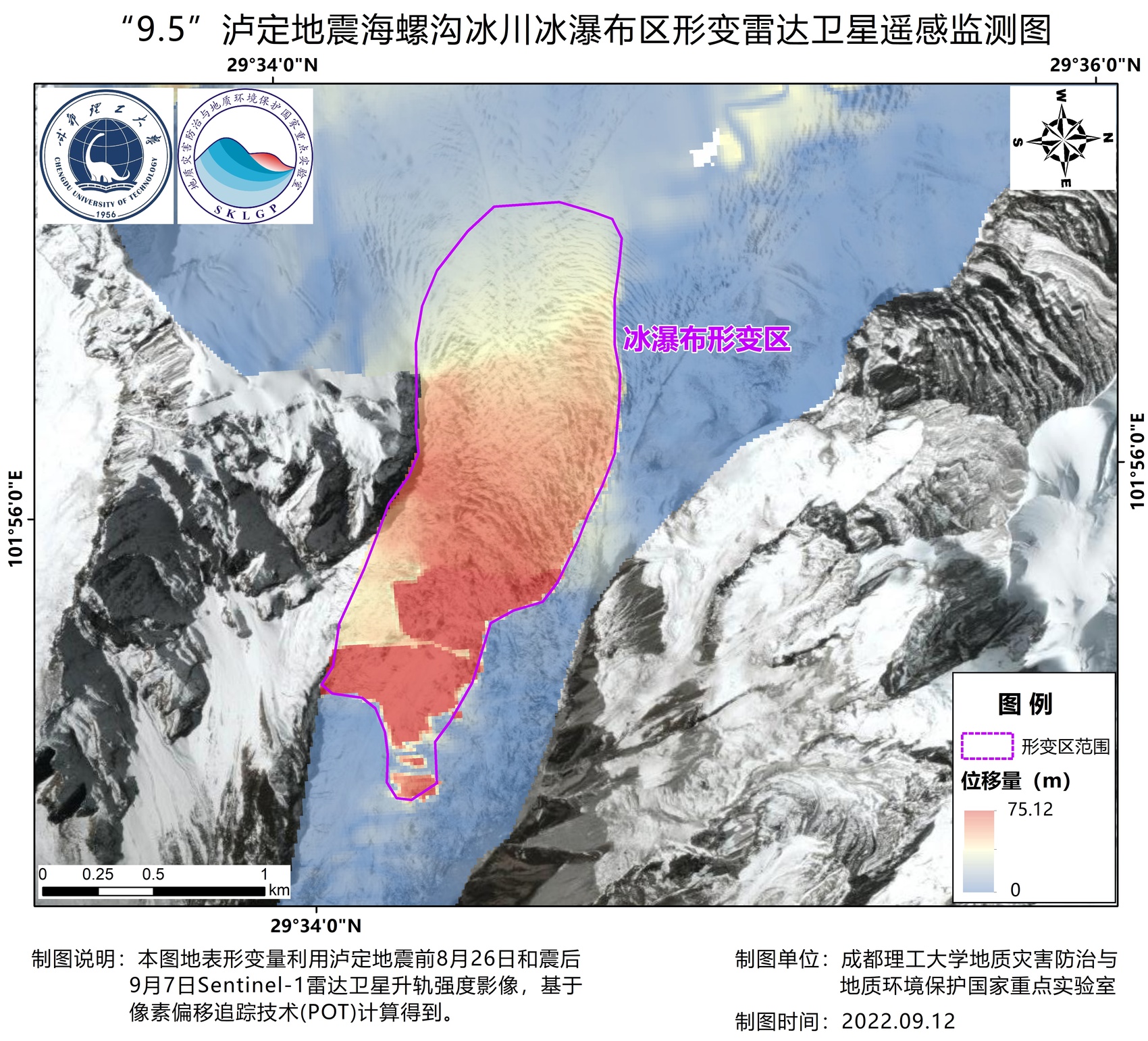
"9 · 5" Luding Earthquake Global Glacier Ice Waterfall area -shaped radar satellite remote sensing monitoring diagram Li Weile's picture
The results also showed that the Hailou Glacier was most affected by the earthquake, especially in the position of the front edge ice waterfall. It monitored a large -scale continuous variable area, with an area of about 2 square kilometers and a displacement of about 30 meters.
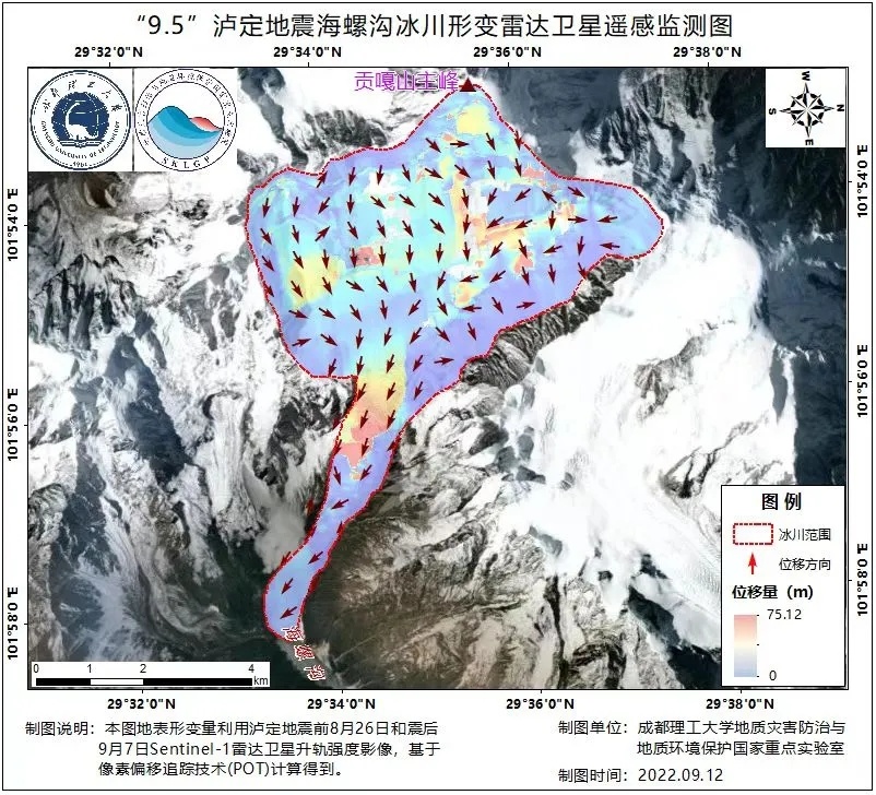
"9 · 5" Luding Earthquake Glacier Glacier -shaped Radar Satellite Remote Sensing Monitoring Monitoring Li Weile Figures
Li Weile emphasized that the above results are only obtained by the comparison of radar satellite images before and after the earthquake, and have certain reference value. However, the specificity of the deformation and whether the subsequent impact will cause the impact of ice lambling, and it is still impossible to judge. The subsequent use of the airborne platform to obtain high -resolution aviation images for detailed deformation investigations and analysis.
After the earthquake, many parties have always paid close attention to whether the Hailou Glacier closer to the epicenter is abnormal. Liu Qiao, a researcher at the Institute of Mountain Disaster and Environment of the Ministry of Water Resources of the Chinese Academy of Sciences, has long been engaged in observation and research on glaciers and climate change.
In response to the results of the above-mentioned variants, Liu Qiao proposed that the Hailugou Glacier is a relatively fast ice bucket-Valley Glacier, especially the area near the area near its ice waterfall. The large amount of glacier material in the wide accumulation area of the Hailou Global Glacier is transported downstream under the action of gravity. After entering the narrow valley of the downstream of the snow basin, it converges, and immediately remit into the steep ice bed valley with an average slope of up to 35 degrees, forming a vertical height difference of 1080 up to 1080 The ice waterfall of rice has led to the surge in the speed of the ice flow.
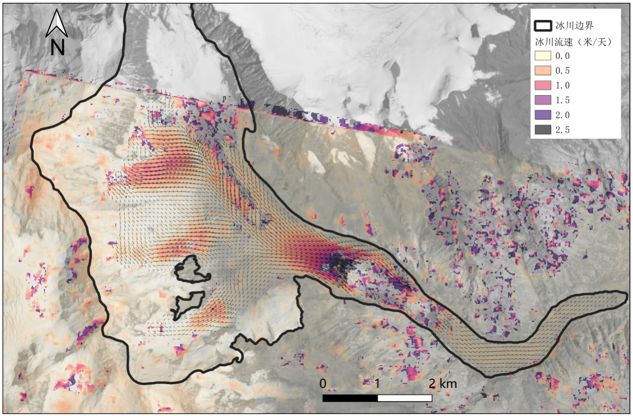
Hailugou Glacier Spring Ice Flow Flow (2018.04.04–2018.04.20) based on optical image extraction
According to the results of the glacier observation of the Liu Qiao team, the upstream of the Hailuo Glac Ice Waterfall is as high as 2 to 3 meters per day, and the summer flow rate is higher, more than 4 meters/day; while the main area of the ice waterfall, the flow velocity is higher. Therefore, the glacier flow detected by the sentinel radar image during this earthquake should belong to the normal range. Whether it is the impact of earthquake activities on glaciers, and the analysis of timing changes in the predecessor of the earthquake to comprehensively judge.
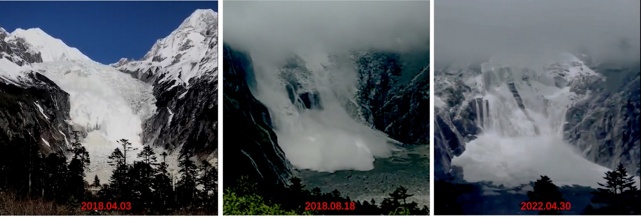
Recently, the large -scale ice collapse of the Hailuogou Glacier Ice Waterfall has occurred in the past few times
It is understood that Hailuogou Ice Waterfall has previously connected to the downstream iced tongue. In recent years, due to the continuous decrease in glaciers, it has gradually disconnected with the iced tongue. After the disconnected ice waterfall, due to the loss of ice stress support, the frequency and scale of collapse have increased significantly compared to the past. Several large -scale ice (snow) collapse in the day. Liu Qiao pointed out that at present, the size of the ice collapse of the Hailugou Glacier during the Luding earthquake is not large, and the long -range flat tongue area under the ice waterfall has a good buffer in the collapsed ice and snow material movement. The possibility of Bingnu disaster or further forming a disaster chain is relatively small.
However, he also noticed that the upstream of the earthquake in the earthquake should be intensified before and after the occurrence of the earthquake, the motion of the ice -cutting landless landform disturbance, and the possibility of stacking rainfall induced the local mudslides in the glacier and its downstream region. In the later period, continuous monitoring is needed, and combined with field surveys in the wild, comprehensively evaluate the impact of the disaster and water changes that may cause the abnormal glacier to cause the stack of the disaster in the earthquake area.
At present, the only road from Moxi Town to the Hailuogou Scenic Area is severely damaged in the earthquake, and it is still in the middle of the earthquake. The expert team cannot enter the on -site observation. In addition, the complex and changing clouds and rain weather in Yamauchi also restricts visible light remote sensing detection operations.
The reporter learned that the National Key Laboratory of Geological Disaster Prevention and Geological Environmental Protection of Chengdu University of Technology has joined the relevant human aircraft carrier laser radar airline projects from relevant provincial departments, which includes aerial shooting tasks for Ha Luogou Glacier. The plane has arrived at Musi Town on the 12th and will choose to shoot visible light and lidar data on glaciers. It is expected to obtain first -hand information.
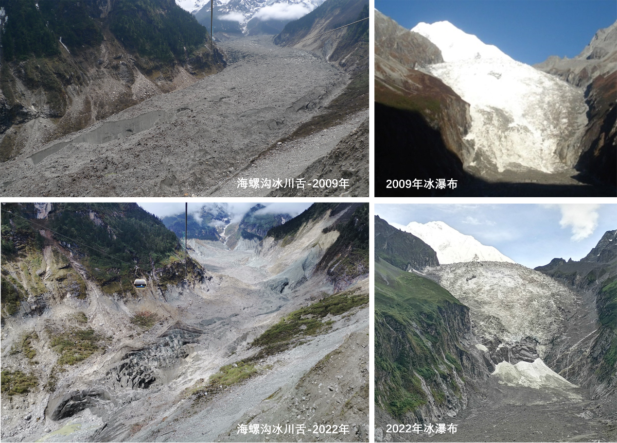
Comparison of the changes in the glaciers of the conch in 2009 and 2022 Figure Liu Qiao Photo
It is understood that the Hailugou Glacier is the only low -altitude inland glacier in the world. In recent years, it has been severely retreated by climate warming. According to the data provided by Liu Qiao, since the age of childhood, the retreat from the glacier has exceeded 2 kilometers. From 1966 to 2009, the average glacier retired by about 25-30 meters per year, while the retreat rate of retreat from 2016-2020 exceeded 50 meters per year. The thickness of the thickness of the icing tongue is as thin as 2-3 meters per year.
- END -
Someone was deceived 300,000 yuan, and the new scam was aimed at college students!
Hello, this is the Alipay front desk customer service. Are you still choosing Huayan and borrowing? On the morning of September 2, Xing Zhengyu, a criminal investigation police officer in Hezhuang P
Leigonghu Community: Free medical examination at the door, the elderly are happy with eyebrows

Yueyang Evening News All Media News (Special reporter Huang Yawen Correspondent Hu...