Important reminder: There will be a strong precipitation in Shanghai tomorrow, and the territorial rainstorm!The possibility of "plum blossoms" is increasing in my country, and Zhejiang waters will lift up 10 meters of wild waves →
Author:Look at the news Time:2022.09.11
Two days of holidays have passed
The weather in Shanghai is still very powerful
today
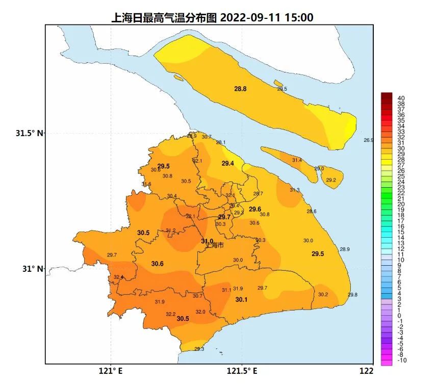
The weather is generally appropriate, mainly cloudy
The lowest temperature in Xujiahui Station in the morning is 24.0 ℃
The highest temperature during the day is generally around 30 ° C

but
Affected by Typhoon "Plum Blossom"
The good weather in Shanghai will come to an end
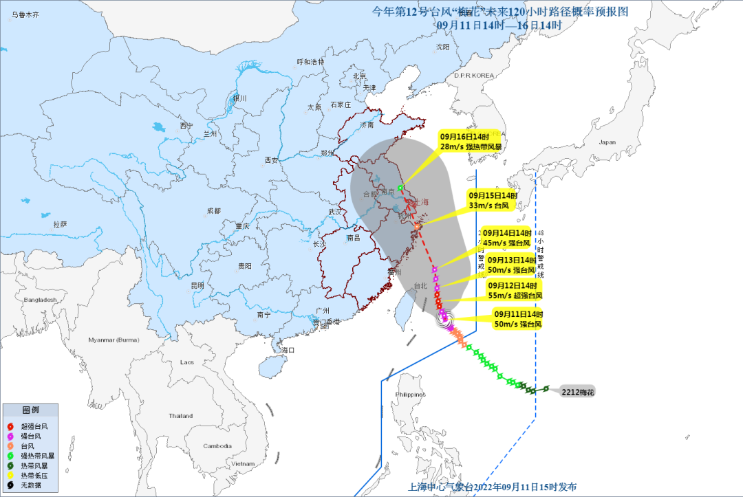
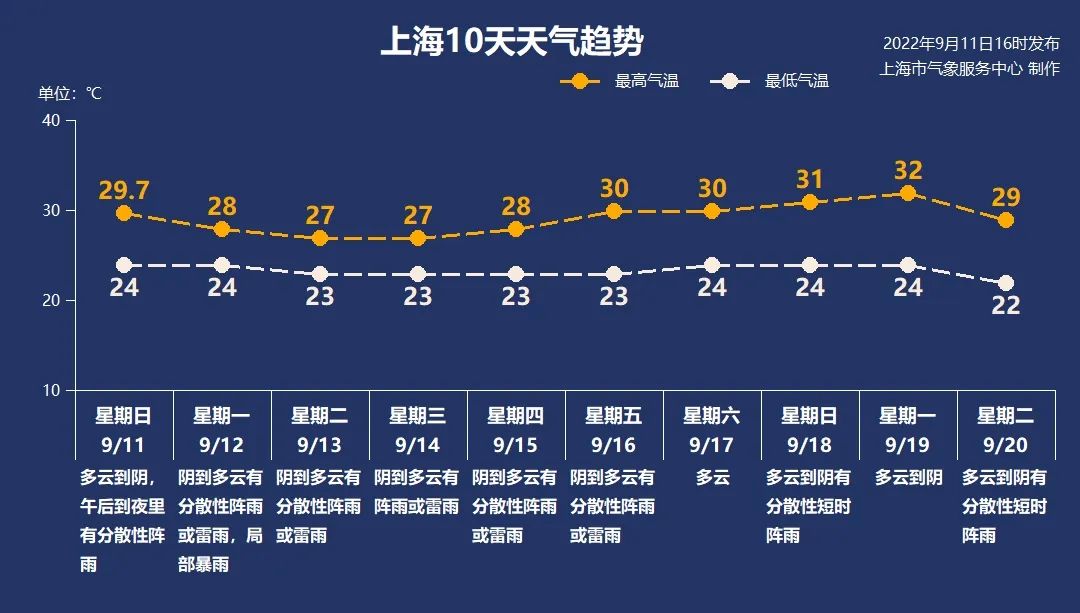
According to the Shanghai Central Meteorological Observatory, Typhoon Plum (Plum Blossom "(strong typhoon) this year was strengthened into a strong typhoon level in the early morning of today (11th). Affected by it, two days after the Ming Dynasty, there was a strong precipitation, the rainfall distribution was unevenly distributed, there were heavy rain in local areas, accompanied by lightning and lightning; there was a clear wind and rain from 14th to 16th.
The possibility of "plum blossoms" in my country increases
Zhejiang waters will lift 10 meters mad
Today, the Central Meteorological Observatory issued a typhoon blue warning. It is expected that "plum blossoms" will move north to west at a rate of 5 to 10 kilometers per hour, and the intensity will be slowly enhanced, with the strongest level of 16 (super typhoon level). It is expected that after entering the southern sea of the East China Sea tomorrow, it will gradually approach the coast of the eastern part of Zhejiang, and may land on the 15th or wipe the above -mentioned coastal areas.
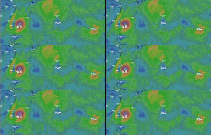
According to the weather in Zhejiang, the path of the typhoon "plum blossom" today is obviously west, which means that the possibility of "plum blossoms" landing in my country is increasing, but there is still uncertainty. (Click to view the typhoon path in real time)
Affected by Typhoon Plum (strong typhoon level) No. 12 this year, it is expected that from the 13th to 15th, a typhoon storm process will occur along the coast of Zhejiang Province. It is expected that from the 13th to 15th, a large storm process will occur in the waters of Zhejiang Province, and the largest will appear from 14th to 15th. 8.0 to 10.0 meters of mad waves will appear from the waters of Zhejiang Province.

There is a strong precipitation on the day after tomorrow in Shanghai
Local heavy rain
As the typhoon "plum blossom" gradually travels north, the weather in Shencheng will change.

In terms of precipitation, affected by the low overwhelming tank on the north side of the typhoon, there will be strong precipitation in Shanghai on the day after tomorrow, the rainfall distribution is unevenly distributed, there are heavy rains in local areas, accompanied by lightning and lightning; cumulative rainfall is 50 to 70 mm, and local areas are 80 to 100 mm. Individuals are individual. The area can reach 120 to 150 mm, and the maximum hourly rain is 30 to 50 mm.
From 14th to 16th, in the influence of the typhoon "plum blossom" and the ontology, Shanghai has obvious wind and rain. However, the typhoon forecast may still change. At present, there are inland low pressure and tropical disturbances on the east side at sea. In the later period, it will have a great impact on the path of typhoon "plum blossoms".

The National Defense Flood and Flood Prevention and Typhoon Class 4 emergency response
Send a working group to Zhejiang to assist in guidance work
The Central Meteorological Observatory issued a typhoon blue warning on September 11. It is expected that typhoon "Plum Blossom" No. 12 this year will enter the southern sea surface of the East China Sea on September 12th to move northwest at a speed of about 10 kilometers per hour. , Shanghai, Jiangsu, Shandong and other places will have heavy rain and heavy rain. According to the relevant provisions of the "National Flood Control and Drought Resistance Emergency Plan", the National Defense Corporation launched the four emergency responses of flood prevention and typhoon prevention at 17:00 on September 11, and sent two working groups to Jiangsu and Zhejiang to assist in guidance.
Zhejiang launched the emergency response of typhoons at sea
According to the "Zhejiang Province Flood Control and Drought Resistance Emergency Plan", the provincial defense index decided to launch a maritime typhoon emergency response at 16:00 on September 11. All localities and departments should pay close attention to the development of typhoons, focus on the "eight risk lists" of flood prevention and prevention platforms, strengthen research and judgment and control, and effectively do a good job of typhoon "plum blossoms" defense.
Ningbo launched the emergency response of typhoons at sea
According to "Ningbo Release", according to the "Emergency Plan for Drought Resistance Resistance in Flood Control, Flood Prevention and Taiwan", the city defense index was decided to launch a typhoon prevention emergency response at 14:00 on September 11.
Wenzhou launched a typhoon prevention level IV emergency response
According to the "Wenzhou Release", according to the "Wenzhou Flood Control and Drought Resistance Emergency Plan", Wenzhou's defense index decided to launch a typhoon anti -level emergency response at 12 o'clock on September 11. Affected by it, there were obvious weather in Wenzhou on 12-15.
Zhoushan launched a typhoon prevention level IV emergency response
According to the news of "Zhoushan Release", according to the "Drought and Drought Control and Taiwan Emergency Plan for Flood Control, Drought Control and Drought Control,", the Municipal Defense Index decided to launch a typhoon -resistant level IV emergency response at 18:00 on September 11. All localities and departments are requested to continue to pay attention to the latest trends of typhoons and do a good job of typhoon "plum blossoms".
Taizhou launched a typhoon prevention level IV emergency response
According to the "Taizhou release", according to the emergency plan of the Flood Control and Taiwan Flood Control Taiwan, the city defense decision decided to launch a sea -level emergency response at the sea of typhoon prevention at 15:00 on September 11. All localities and departments are requested to do a good job of the typhoon "plum blossom" in accordance with the plan.
Why is the autumn typhoon more ruthless?
Since September, the two consecutive typhoon "Xuan Lannuo" and "Plum Blossoms" have gone to the level of super typhoon. In fact, the "autumn typhoon" born from September to November is indeed stronger.
Judging from the situation of landing in my country, the influence of Typhoon Qiu cannot be underestimated. Data from 1949 to 2020 showed that the average of about 4.43 typhoons landed in my country on average in summer, which is the most season for typhoons to land in my country; and average 2.36 typhoons in our country each year to land in my country for the second active season for typhoons. In the middle of autumn, September was the most active, with an average number of login reaching 1.72, second only to the most frequent August (1.94) and July (1.83) of typhoon activities, the difference was small.
Although the number of typhoons and login in summer is the largest of the year, big data of meteorological shows that autumn typhoons are more likely to produce "ruthless characters". From 1949 to 2020, the typhoon generated in autumn accounted for 27.9%, which was far higher than 18%in summer. Judging from the intensity of typhoons for the first time, the autumn typhoon is significantly higher than the summer typhoon. In summer, typhoons are mostly landed in our country at the level of tropical storms or strong tropical storms, reaching only 14.9%to reach the level of strong typhoons. In the fall, this ratio is 22.4%, which is significantly higher than summer.
Why is the autumn typhoon destructive? Usually from August to September, the sea temperature reaches the highest, and the high sea temperature is conducive to the generation of typhoons and energy enhancement. At the same time, during this period, cold air began to active, increasing the gradient of the air pressure, and the increase in wind speed near the typhoon center was also conducive to the intensity of typhoons. Therefore, the probability of strong typhoons or super typhoons in autumn was higher.
Typhoon autumn is not only prominent, but also weird and changing on the path. This is related to the weather system that affects the autumn typhoon. Meteorological experts said that in the autumn, such as west wind bands, subtropical high pressure, cold air, etc. These weather systems play each other, so typhoons have become overwhelmed, south and south. Essence
This article is comprehensive: Shangguan News, China Meteorological Bureau, Zhejiang News
Related authors: Qi Yingyu
WeChat Editor: Jiasin
- END -
Ping'an Village, Nangang Town, Zhengding County: Party building leads the "new chapter" of rural rejuvenation in the countryside

Hebei Communist Party Member Network News Ping'an Village is located about 10 kilo...
Wenshan Prefecture Culture and Tourism Bureau launched the "6.26" international anti -drug day theme publicity activity

Cultural Tourism Head News (Rong Media Reporter Li Jiairongwen) In order to popula...