"Plum Blossoms" strengthened into a strong typhoon level, Zhejiang in the next few days ...
Author:Voice of Zhejiang Time:2022.09.11
Source: Comprehensive Zhejiang Voice Reporter Cai Jikang, Zhejiang Weather, China Blue News
The copyright belongs to the original author, if there is any infringement, please contact it in time
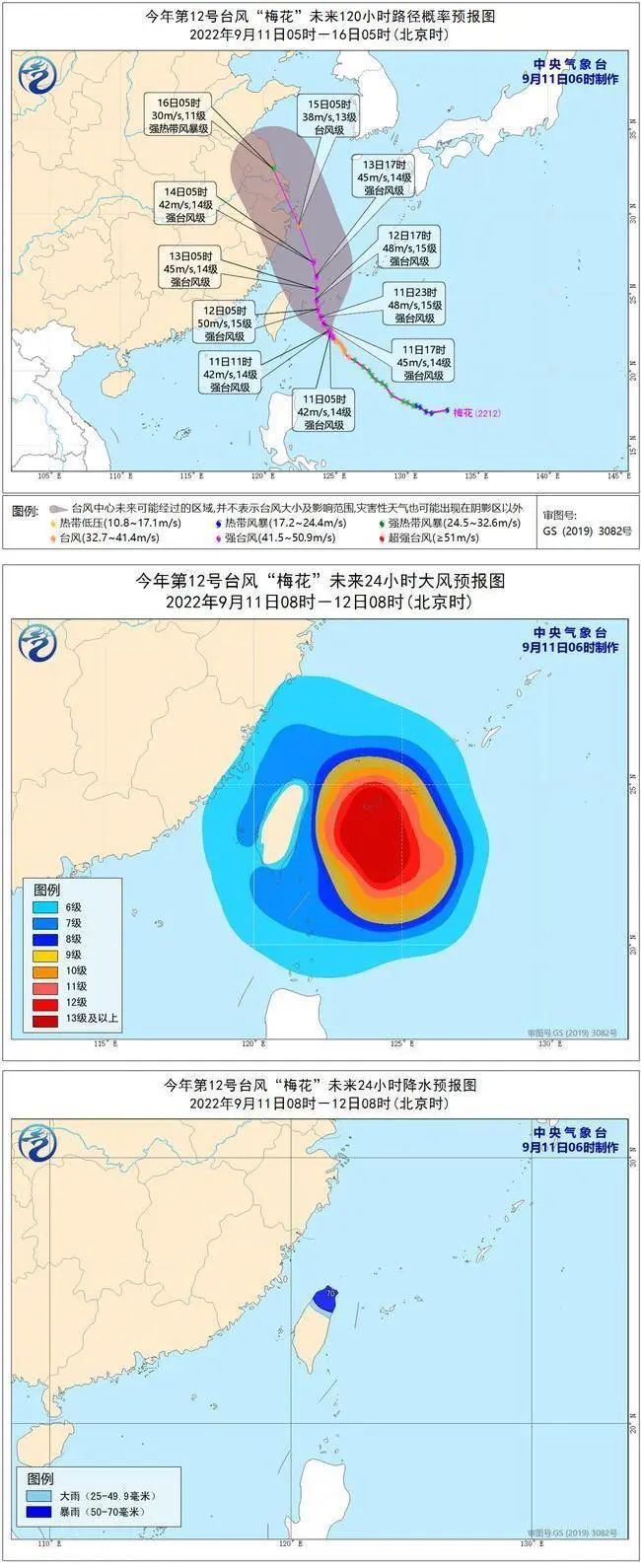
The Central Meteorological Observatory issued a typhoon blue warning at 6 o'clock on September 11: Typhoon "Plum Blossom" No. 12 this year was generated on the northwest Pacific Ocean at 8 am on September 8th. At 5 am, the center is located on the northwest Pacific Ocean (22.4 degrees north latitude and 124.7 degrees east longitude) at 440 kilometers southeast of Taipei City, Taiwan Province. Pa, the seven -level wind ring radius is 260-300 kilometers, the ten -level wind ring radius is 70 kilometers, and the 12 -level wind ring radius is 30 kilometers.
It is expected that "plum blossoms" will move northwest at a rate of 15-20 kilometers per hour, and the intensity will gradually increase, the strongest can reach 45-50 meters/second (level 14-15, strong typhoon). On the evening of the 12th, the intensity began to weaken slowly, and continued to move northwest. After passing through the Ryukyu Islands, entered the southern sea surface of the East China Sea. It gradually approached the coast of the eastern part of Zhejiang.

Dafeng forecast: 8:00 on September 11th to 8:00 on the 12th, the southern sea surface of the East China Sea, the Taiwan Strait, Taiwan's East Ocean, Bus Strait, the coast of Taiwan Island, and the waters near the Diaoyu Islands have 6-7 Grade Winds. ; The southeast of the East China Sea and some of the waters east of Taiwan have 8-11 gale. The wind in the nearby sea and regions passed by the "Plum Blossom" center is 12-15, and the gusts can reach level 16.
Precipitation forecast: From 8:00 on September 11th to 8:00 on 12:00, there will be middle to heavy rain in northern Taiwan and heavy rain.
Defense guide:
1. Government and relevant departments do a good job of preventing typhoon rescue emergency in accordance with their duties.
2. Related water operations and past ships should return to the port to avoid wind, strengthen port facilities, and prevent the ship's anchor, stranding and collision.
3. Stop outdoor dangerous operations such as large -scale rally indoor and outdoor and high altitude.

- END -
The cooling effect of "timely rain" see the shadow!But the high temperature crit will return soon!

notSource: Zhejiang Weather, China Blue NewsThe copyright belongs to the original ...
"Earthwen Heart" Yunnan Xing —— face to the Dianchi Lake with a clean mentality
Siyucai rice, thousands of hectares of sunny sand, Jiuxia Furong, Sanchun willow, in the hearts of old Kunming people, it was the most beautiful existence and greatest pride in his hometown. In the 1