Typhoon "Plum Blossoms" strengthened rainfall in the southwestern region of a strong tropical storm
Author:Global Times Time:2022.09.09
China News Service, September 9th. According to the website of the Central Meteorological Observatory, Typhoon Plum Blossom No. 12 this year was strengthened from a tropical storm to a strong tropical storm in the early morning of the 9th. It is expected that "plum blossoms" will be about 15 kilometers per hour. Move towards the northwest, the intensity gradually increased (the strongest can reach the strong typhoon level, 45-50 meters/second, level 14-15), and approached the Ryukyu Islands. In addition, at 8:00 on September 9th to 8:00, there are medium to ~ 60 mm).
There are rainfall in the southwest
From the 9th to 11th, there are small rain to the middle of the eastern part of Tibet, central Sichuan, Guizhou, Yunnan, and Shaanxi, Shanxi, Henan and other places, and the eastern part of the Southwest region is as heavy as heavy rain. There is a short -term heavy precipitation (20 ~ 40mm/h, and the local area is 50mm/h).
Typhoon "Plum Blossom" is strengthened to a strong tropical storm level
Typhoon No. 12 this year "Plum Blossom" was strengthened from a tropical storm to a strong tropical storm in the early morning of the 9th. It was located on the ocean surface of about 960 kilometers east of Naha, Naha, Okinawa Prefecture, Japan. Level 10 (25 meters/s), the lowest air pressure in the center is 985 hundred Pache, and the seven-level wind ring radius is 120-380 kilometers.
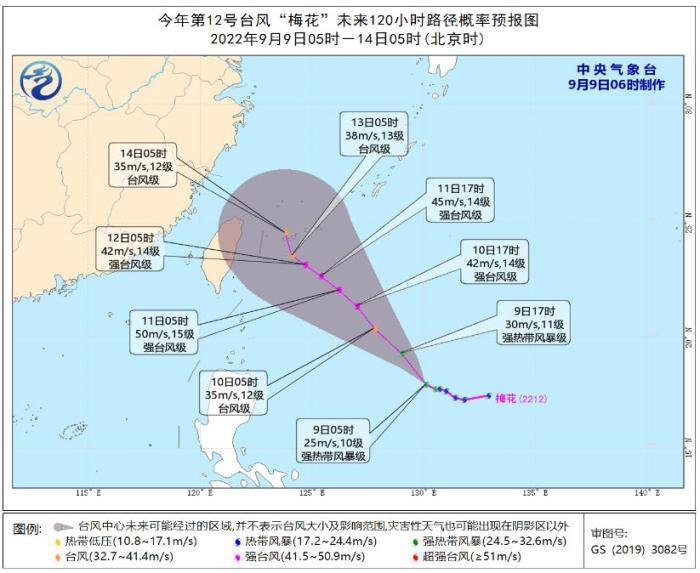
It is expected that "plum blossoms" will move northwest at a speed of about 15 kilometers per hour, and the intensity will gradually increase (the strongest can reach strong typhoon grade, 45-50 meters/second, 14-15) see picture 1).

Figure 1 Typhoon "Plum Blossom" Path Path probability forecast chart in the next 120 hours
Specific forecast in the next three days
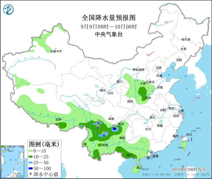
From 08:00 on September 9th to 08:00 on the 10th, there are mid -to -heavy rain in eastern Tibet, southern Tibet, southern Sichuan, northwest of Guizhou, southwestern Guangxi, and southwestern Shanxi, northwestern Henan, and other areas. Millimeter). There are 4 to 5 winds in parts of the eastern part of Inner Mongolia (see Figure 2).

Figure 2 National precipitation forecast map (September 9th 08-10 08:00)
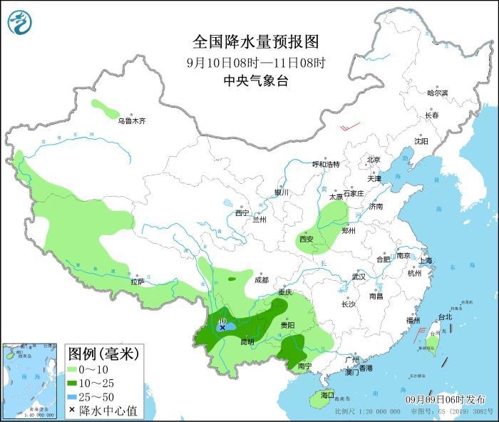
From 08:00 on September 10th to 08:00 on the 11th, there were medium rain in southern Sichuan, northwestern Guizhou, central Yunnan, and west of Guangxi. Among them, there were heavy rain (25-40 mm) in parts of central Yunnan and other places. There are 4 to 5 winds in parts of the central and eastern parts of Inner Mongolia (see Figure 3).

Figure 3 National precipitation forecast map (September 10th to 08:00 on September 10th)
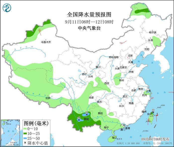
From 08:00 on September 11th to 08:00 on the 12th, northeast of Inner Mongolia, northern Heilongjiang, western and northern Xinjiang, most of Tibet, Yunnan, western Guangxi, northern Taiwan Island and other areas are small to middle rain, of which There are heavy rain (25-45 mm) in parts of central Yunnan and northern Taiwan Island. There are 4 to 6 winds in part of the central Inner Mongolia (see Figure 4).

Figure 4 National precipitation forecast map (September 11th to 08:00 on September 11)
Source: China News Network
- END -
Epidemic Science | What should I pay attention to when detecting nucleic acid testing?A set of posters tell you!

A set of posters remind youPay attention to these details during nucleic acid test...
Xichuan County Museum: Placing "Xichuan Living Room" to polish the "Cultural Window"
In the Conceptual ability style construction year activity, the Xichuan County Museum adheres to work practice, enhances the responsibility of practical work, strengthens ideological leadership, and