China Aerospace Choi Aid Sichuan Luding
Author:Chinese aerospace Time:2022.09.07
At 12:52 on September 5, 2022, Beijing time, a magnitude 6.8 earthquake occurred in Luding County, Ganzi Tibetan Autonomous Prefecture, Sichuan, with a depth of 16 kilometers.
After the earthquake, the relevant units of the aerospace system started the emergency response mechanism for the first time, and urgently assisted Sichuan Luding to resist earthquake relief.

At 13:00, the National Disaster Reduction Center and the Sichuan High Score Center emergency needs are connected. No. 3 01/02/03 star, high score No. 1 D Star, Gao Jing No. 1, Haisi No. 1, Chaohu No. 1, Beijing No. 3, Jilin No. 1, Star Age-9, Qilu No. 1, No. 1, Qilu No. 1 Satellite emergency imaging of the earthquake area.
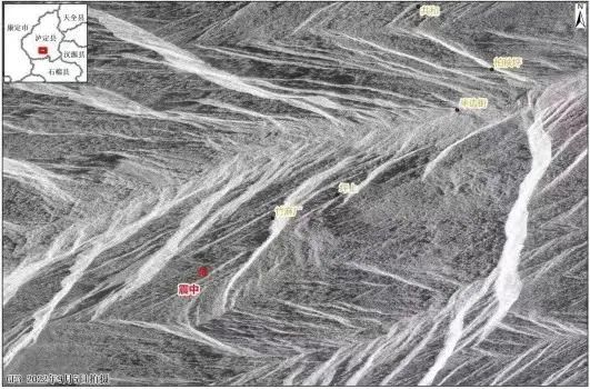
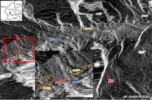
Among them, the high score No. 3 satellite obtained the SAR image of the earthquake area at 19:11 on the same day and distributed it to the National Disaster Reduction Center, the China Earthquake Administration Institute of Earthquake Prediction, the Sichuan High Score Center, and the local emergency department and units, and the emergency department After getting the data with the unit, the analysis was analyzed as soon as possible to obtain the damage to the disaster area.

Remote sensing image map after a magnitude 6.8 earthquake in Luding County, Ganzi Prefecture, Sichuan (19:00 on September 5, 2022)

Remote sensing image map after a magnitude 6.8 earthquake in Luding County, Ganzi Prefecture, Sichuan (19:00 on September 5, 2022)

The Aerospace Science and Technology Group coordinated satellite resources for the first time, and selected backbone engineers to carry the equipment at 1:40 am on the 6th to rush to the scene to ensure that the communication in the disaster area was unblocked.
At the same time, the emergency guarantee mechanism is quickly launched, and high -quality satellite resources such as Zhongxing 16, Zhongxing 6D, Zhongxing 10, and Zhongxing 12 are allocated.
Provide network guarantee services for the first emergency rescue team through satellite portable stations and vehicle stations, and opened a epicenter emergency satellite communication network for the Ganzi Musi West Frontline headquarters to provide command dispatch communication services on site, deploy satellite resources and equipment to ensure the local area The town government emergency communication link guarantee demand.

While grabbing communication links in the earthquake -stricken area, it opens satellite resources for Sichuan TV Station to ensure the demand for news live broadcasts, and to ensure the real -time transmission of on -site information on the disaster area; provide emergency communication guarantee for satellite resources for Sichuan forest fire protection; 2. Establishment of the "Air Base Station" to perform public communication coverage tasks to provide satellite resources to ensure rescue and disaster relief commands and affected people's communication services.
In the future, each unit will provide strong support for disaster rescue and disaster assessment according to the needs of the disaster and relevant departments in a timely manner and scientific deployment of resources.
Source | China High Score Observation, China Aerospace Technology Group Co., Ltd., CCTV News
Edit | Li Nan Wanke Zhou Xinyue
- END -
Ningluo High -speed Luanhe Section: Driver of a car driver is fatigue, and the rear -end truck is damaged!

Dahe Daily · Yu Video Reporter Liu Guangchao Correspondent Wang XiugenAt 23:00 on...
The province's natural resource system celebrates the preparation of the home activities of the Chinese Farmers' Harvest Festival in Harmony

On September 6, the province's natural resource system celebrated the preparatory ...