The emergency response of major meteorological disasters (typhoons) in Zhejiang was adjusted to level I, and Ningbo and Zhoushan Meteorological Bureau entered the status of level I!"Xuanlan Nuo" from the morning of the 5th to the morning of Zhejiang
Author:Voice of Zhejiang Time:2022.09.04
Source: Zhejiang Voice Comprehensive Reporter Zhang Zeyu, Zhejiang News Client, Zhejiang Weather, China Meteorological Bureau, Zhejiang Expressway, Hangzhou Traffic Police
The copyright belongs to the original author, if there is any infringement, please contact it in time
Super Typhoon "Xuan Lannuo" latest developments
Typhoon No. 11 this year's "Xuan Lannuo" (Super Typhoon Level) center on the East China Sea about 325 kilometers from the southeast of Zhujiajian Island of Zhushan City tonight. From 5 o'clock this afternoon to 8 o'clock tonight, "Xuan Lannuo" moved about 24 kilometers towards the northeast. 10-30 mm precipitation appeared in Shaoxing, Ningbo, Zhoushan, western Hangzhou, and eastern Jiaxing. The county (city, district) has a large rainfall with 20.4 mm in Haishu District, 17.6 mm in Fenghua District, and 16.8 mm in Puzhou District; the coastal sea surface of Zhejiang has a level of 8-10 grades.
The Zhejiang Meteorological Bureau adjusted the major meteorological disaster (typhoon) business service level Ⅱ emergency response to level Ⅰ tonight, and Ningbo and Zhoushan Meteorological Bureau entered the status of level I. It is expected that "Xuan Lannuo" will move around the north near the east of 124 degrees at a speed of about 15 kilometers per hour today from the speed of about 15 kilometers per hour, and the intensity may also increase to level 17. Typhoon today will have a continuous impact on the East China Sea and the coastal sea surface. Today, it will be as some of the heavy rains in the eastern part of Zhejiang and north tomorrow. Among them, there are heavy rain in Ningbo, Shaoxing, and Zhoushan.
According to Xinxin analysis of the meteorological channel of the Chinese meteorological channel, from the cloud map of today's evening, the superb Typhoon Xuan Lan Nuo, the high -voltage clear sky area is not obviously westward, so Xuan Lannuo will not land in my country. The path has been greatly converged. Judging from the forecast path of the Central Meteorological Observatory, on the morning of the 5th to the morning, Xuan Lannuo Center was closest to the Zhejiang coast, about 200 kilometers. After noon on the 5th, it gradually accelerated to the northeast and landed in South Korea on the morning of the 6th.
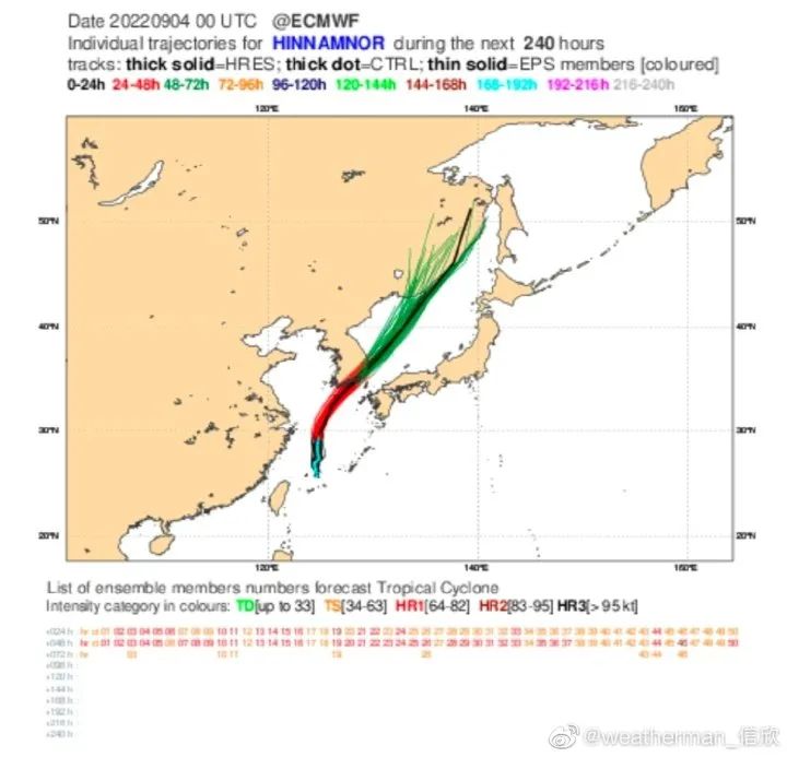
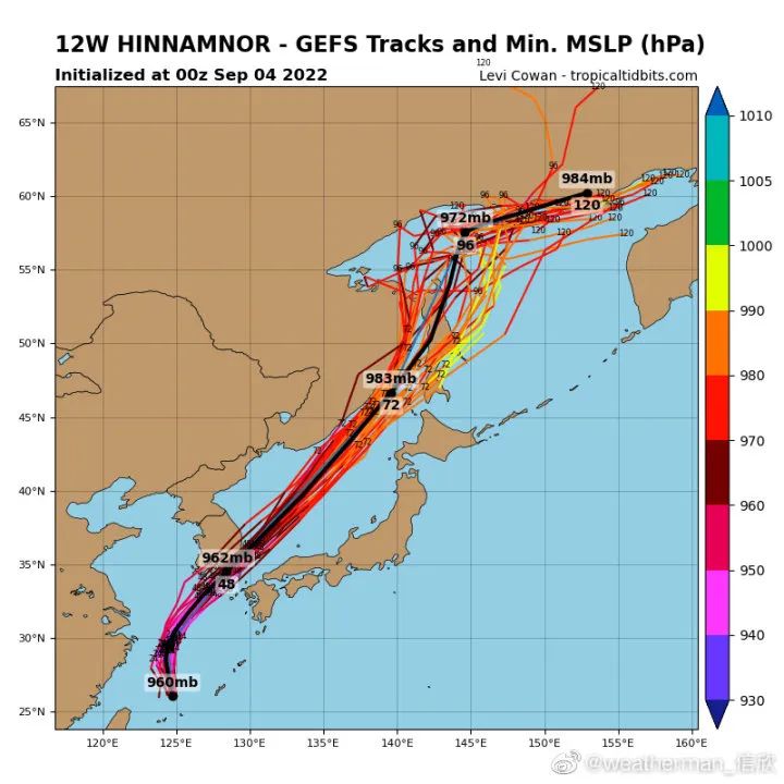
Provincial Emergency Department:
As of 2 pm today, the province transferred a total of 312177 people
The reporter learned from the Provincial Department of Emergency that as of two pm today (0904), a total of 312,177 people in the province had been transferred to the province, with a total of 7,309 places for disaster avoidance resettlement (1634 in use places), and 60,693 people were concentrated.
As of today's 18:00
Affected by typhoons
Some high -speed speed limit lines in Zhejiang
Due to the influence of the typhoon, the jurisdiction of Zhoushan: G9211, Yongzhou High Speed Double Bridge to the Sichuan section 60 km/h; S6 Dingye high -speed full section of the speed limit of 60 km/h, currently: rich wings, Ligang, Luanchuan, booklet interoperability interoperability The water accumulation is serious, at the same time, the visibility is low in 42 kilometers-45 kilometers (sections near Libang). In addition, the influence of the horizontal wind is relatively large. Please pass the steering wheel in the past, slow down, and use the lights reasonably.
Due to the influence of typhoon, Ningbo jurisdiction: G15 Shenhai high -speed south wiring, G1504 Ningbo around the city highway, G92 Hangzhou -Ningbo high -speed, speed limit 100 km/h; G15 Hangzhou Bay cross -sea bridge, G1512 Ningbo section speed limit 80 km/h/h Essence
Due to rainfall, the import of toll stations below the area under the jurisdiction of Huzhou is restricted to the "two customers and one crisis" vehicle: G25 Hanging High -speed Huzhou South, Qingshan, Deqing North, and Deqing imports. G50 Shen Su, Zhejiang and Anhui High Speed Houzhou, Weaoli, and Nanxun are imported in both directions. S12 Shenjiahu Expressway Huzhou East, Shuanglin, and Nanxun South imports;
Due to heavy rain in the S26 Zhuyong high speed, the two -way horse house imported the "two passenger" vehicles.
Zhejiang's current warning over 100
It's best tonight
As of 18:25 pm today, Zhejiang issued a total of 107 early warnings.
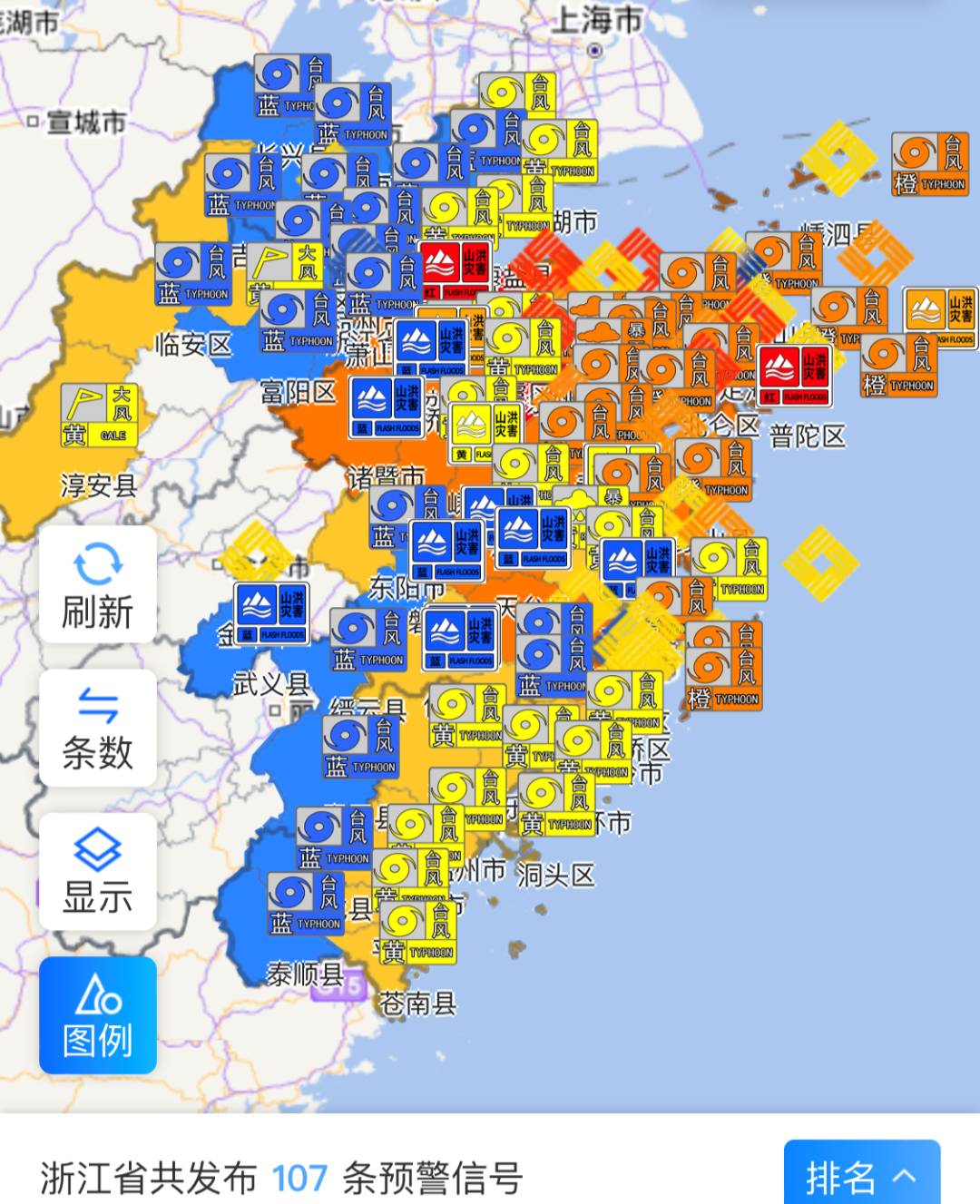
Provincial Meteorological Observatory reminds: In the evening, early warning signals such as wind, heavy rain, typhoon, etc. have been hung high. Friends in the above areas are still the houses on the weekend. Friends who are outdoors still try to hide indoors when they encounter the wind. hide.
Zhejiang issued mountain floods and red warnings
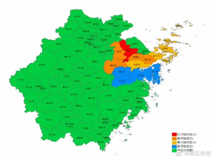
The Zhejiang Provincial Department of Water Resources and Zhejiang Meteorological Bureau jointly issued a red warning of the flood disaster at 17:44 on September 4th: It is expected to be extremely likely to occur at 20:00 on the 4th to 20:00 on the 5th (red warning), Haishu The possibility of flood disasters (orange warning) occurred in the district, Lizhou District, Shangyu District, and Puzhou City. Xiangshan County, Ninghai County, Xinchang County, and Tiantai County may occur (blue warning). Please pay close attention to the changes in the weather situation and rainwater, and pay attention to preventing mountain flood disasters caused by heavy precipitation.
Typhoon Sky Travel Hangzhou Traffic Police Reminder
After the opening of this year (9.1-9.2), the early peak speed of the main urban area is 26.5 kilometers/h, which is 4%compared %. The city's traffic operation speed has only declined slightly, which is the result of the joint efforts of the city's citizens and the traffic police department. However, according to previous years of experience, the city's transportation capacity will decrease by 10%. So tomorrow's early peak (September 5), everyone must prepare in advance.
According to traffic data forecasts, the peak delay index will exceed 2.0 tomorrow. Those who can avoid these periods must avoid.
Morning and evening peak congestion period: 7: 40-8: 40, 17: 30-18: 30
Condorned roads: The main urban area is mainly congested roads: Qiutao North Road Fengqidong Road, Qiutao North Road Qingchun East Road, Bin'an Road Times Avenue, Wangjiang Road Jianguo South Road, Qingchun East Scenic Road, Jiefang Road Jianguo Jianguo Mid -road, Wenyi West Road Jiangdun Road, Zhenhua Road, Zijin Port North Road, Jiangdun Road, Guixiang Road, and Wenhui Road, Shangtang Road. The main congested road section of the fast road: Shangtang Viaduct-Royal Elevated West to the south and east to the south; Qiushi Viaduct-Shideli to the west to the south to the south; Zijin Port Interchange-East Exit North; Fuxing Interchange-The main line of the main line is long-line; Zhonghe Elevated-Wenhui Road ramp.
Affected by the typhoon, before the departure, the drivers pay attention to check the car condition and replace the wiper in time. Driving on rainy days or slippery roads, please keep the windows and reflector clear, control the speed of the car, keep a safe distance from the front car to avoid emergency braking and steering, so as to prevent the side danger from slipping on the car.

When encountering heavy rain, if the effect of the wiper cannot meet the requirements of visibility, do not risk driving. You should choose to park at places that do not affect traffic and safety, and turn on the hazard warning light.
- END -
Multiple platforms are launched to show the "IP ground" function. Where are you?
In order to maintain the order of network communication and further crack down on imitation handling, rumoring and rumors, the WeChat public platform has shown the IP territory when users publish the
Wenzhou Lucheng: Law enforcement supervision and then promoting garbage classification will not be "loose"

Recently, in order to ensure the normal operation of domestic garbage classificati...