"Xuanlan Nuo" will return to the super typhoon level!Xiamen can be over 38 ° C today, and the weather changes to the face ...
Author:Xiamen Daily Time:2022.09.04
"Typhoon Fire" is really "fire"!
"Xuanlan Nuo" go north
Send a hot wave to Ludao
A spectacular cloud gap appeared above Xiamen yesterday
Did you see it?

Photo by our reporter Bai Yibin

Reporter Yang Jinfu Photo

Reporter Wang Huoyan Photo
latest news
"Xuanlan Nuo" will be strengthened to super typhoon again
At 8 am this morning, the center of "Xuan Lannuo" (strong typhoon) is located on the sea about 470 kilometers east of the south of Zhujiajian Island, Zhejiang Province.
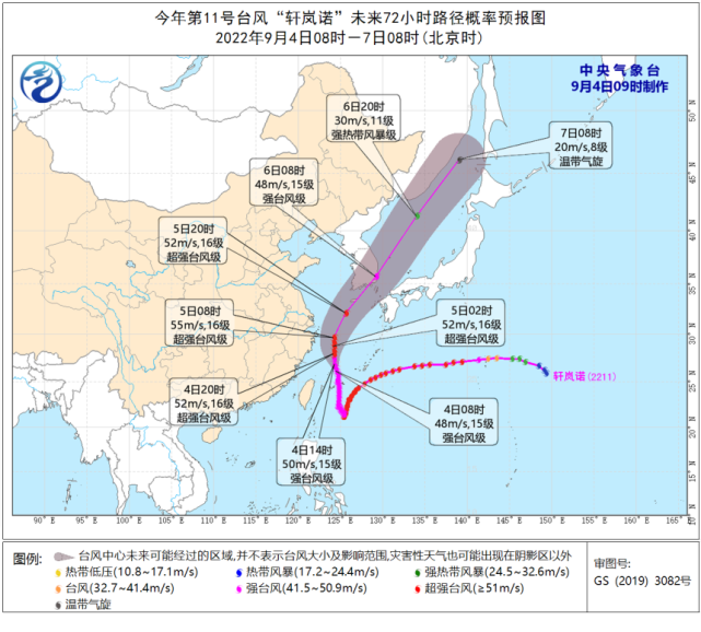
It is expected that it will move north to the west at a speed of 20 kilometers per hour, and the intensity will gradually strengthen. Today, it will be strengthened to a super typhoon grade (level 16, 52 ~ 55 meters per second) during the day. Essence From the night of the 4th to the morning of the 5th, it will move around the northeast near the sea surface of Zhejiang. The last time is about 150 to 170 kilometers from the Zhejiang Coastline, and then gradually moves towards the southern part of the Korean Peninsula to the Korean Strait.
Georgian forecast
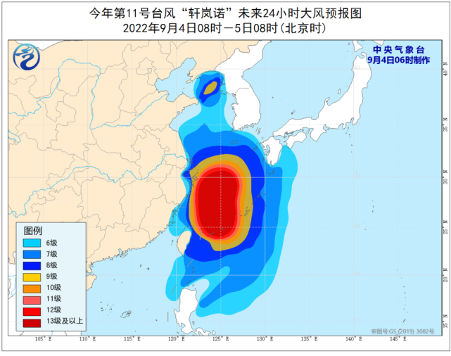
From 08:00 on September 4th to 08:00 on the 5th, the bus strait, Taiwan Strait, Taiwan's east, most of the Yellow Sea, East China Sea, Yangtze River Estuary District, Hangzhou Bay, Taiwan Island and its coast, central and northeast coast of Fujian, northeast Zhejiang, northeast Zhejiang , Shanghai, Jiangsu and the coast, and the coast of the Shandong Peninsula will have 6-9 strong winds, and the gusts are 10-11. Among them, the wind of the most east China Sea, the sea near the Diaoyu Islands, Hangzhou Bay, and the northeast of Zhejiang have 10 winds. -12 levels, gusts 11-13, the wind on the sea across the "Xuanlan Nuo" center is 13-16, and the gusts can reach level 17 and above.
Precipitation forecast
From 08:00 on September 4th to 08:00 on the 5th, there were heavy rain in northeast Zhejiang and northern Taiwan Island. Among them, there were heavy rainstorms in the northeast of Zhejiang (100-120 mm). In addition, there will be heavy rain (25-40 mm) in southern Liaoning and southern Jilin.
Meteorological department forecast
Two days and tomorrow
Affected by the sinking air flow in the periphery of "Xuanlan Nuo"
Xiamen still maintains sunny and hot high temperature weather
Xiamen Meteorological Observatory 8:38
Continue to release a high -temperature orange warning signal

At 8:50 in Tong'an District Meteorological Observatory
Continue to release a high -temperature orange warning signal

Xiang'an District Meteorological Observatory 8:46
Continue to release a high -temperature orange warning signal

Affected by typhoons today, the city's urban area is 3-4 and short-term gusts 6-7, and there are still strong alerts in the coastal areas. Chongwu to Dongshan's coastal sea surface is 5-6 and gusts 7-8. Tomorrow, our city is mainly sunny to cloudy weather.
It is expected to start the day after tomorrow
Northern cold air arrives
The weather in our city will have a cooling and precipitation weather
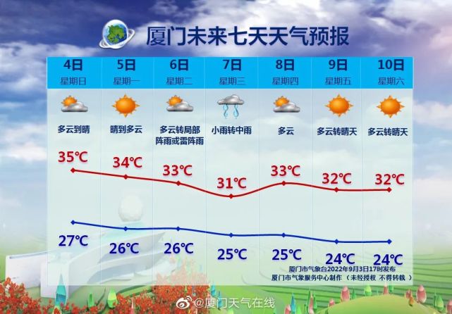
On the 7th, the cold and cold air melee warfare
There will be light rain to the rainy weather in our city
The highest temperature in the urban area will drop to about 31 ° C
Citizens need to prepare rainware
Xiamen Daily Reporter: Zhu Daoheng Comprehensive Central Meteorological Observatory,@Xiamen Weather Online
- END -
Nanyang is among the demonstration city of the national bus city construction
On August 19, a good news from the Nanyang City Transportation Bureau was named by the Ministry of Transport by the Ministry of Transport.On August 19, the Ministry of Transport issued a notice, and c
They sold the peach to "Oriental Pearl"

Retired veterans show a sweet and sweet yellow peachIn Da Jinxing Village in Monke...