The first super typhoon in the year is coming!What impact will it have on my country?The chief expert of the Meteorological Service of China Meteorological Administration explains in detail ...
Author:Daily Economic News Time:2022.09.03
During the year, the first super typhoon striked -after the high temperature in southern China finally "receded", the typhoon that appeared in the past two days once again made the weather a hot topic on social networks.
At 2 am on August 30, Typhoon Xuan Lannuo, No. 11 this year, was strengthened from a strong typhoon to a super typhoon level. Although its intensity was unexpectedly weakened on September 2, it gradually faced with "Xuan Lannuo". my country is close, and its intensity will develop again.
According to the latest news released by the official WeChat of the China Meteorological Administration, as of 17:00 on the 3rd, "Xuanlan Nuo" is located on the east of Taiwan, about 700 kilometers east of Zhujiajian Island, Zhushan City, Zhejiang Province. It is expected that "Xuan Lannuo" will move north to west at a speed of 15 to 20 kilometers per hour, and move into the East China Sea today. The strength of the intensity may be strengthened to a super typhoon level, and gradually approach the coast of northeast Zhejiang.
According to the forecast of the Ministry of Natural Resources, from September 4th to 5th, 8 to 12 meters of mad waves will appear in the East China Sea to the wild wave area.
Along with the typhoon "Xuan Lannuo", there have been many questions on the Internet: why did the first super typhoon not coming in early September? The trajectory of Typhoon "Xuan Lannuo" is quite strange. What is the reason? What impact of typhoons will bring on my country's coastal areas?
With these issues, the reporter of "Daily Economic News" conducted a telephone interview with Zhu Dingzhen, chief expert of the Meteorological Service Center of the China Meteorological Administration's Public Meteorological Service Center.

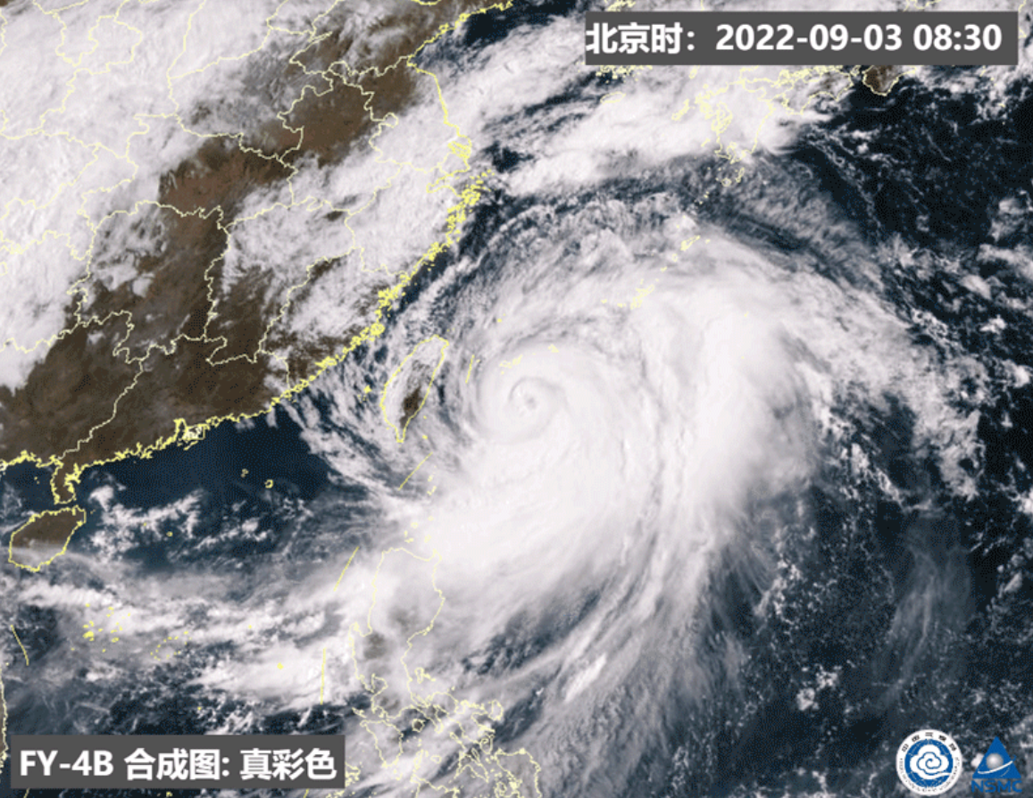
Typhoon "Xuan Lannuo" Satellite cloud map picture Source: China Meteorological Bureau
The less typhoon this year is related to the influence of the La Nina incident
The first super typhoon was ushered in the year at the end of August and early September. For most ordinary people, the first reaction was that this typhoon was "a bit late."
In this regard, Zhu Dingzhen said in an interview with the reporter of the Daily Economic News that this is not only the problem of super typhoons. In fact, the overall time of the typhoon this year is too late, and the number of typhoons is small. Typhoon is equally small.
What is the reason for this phenomenon? Zhu Dingzhen analyzed to reporters that first of all, the number of typhoons was related to the impact of this year's La Nina incident.
Generally speaking, the generation of typhoons requires sea temperature and the circulation conditions that are beneficial to the survival of typhoons, but the emergence of the La Nina incident has caused the circular conditions to weaken compared with the year. Essence
In addition, the phenomenon of less typhoons is also closely related to the long time of high temperature weather this year. The direct reason for the continuous high temperature is the abnormalities of atmospheric circulation and the abnormal distribution of the subtropical high pressure this year, and the abnormal distribution of the subtropical high pressure also causes abnormal circulation of the typhoon activity area on the south side of the subtropical high pressure, which is not conducive to the development of typhoons.
"Daily Economic News" reporter noticed that the first super typhoon in 2020 did not only appear until the end of August and early September: at 05 on September 1 of that year, Typhoon Michard "Masak" was strengthened to super typhoon It became the first super typhoon during the year.
The "Xuanlan Nuo" path is abnormal due to guiding changes in airflow
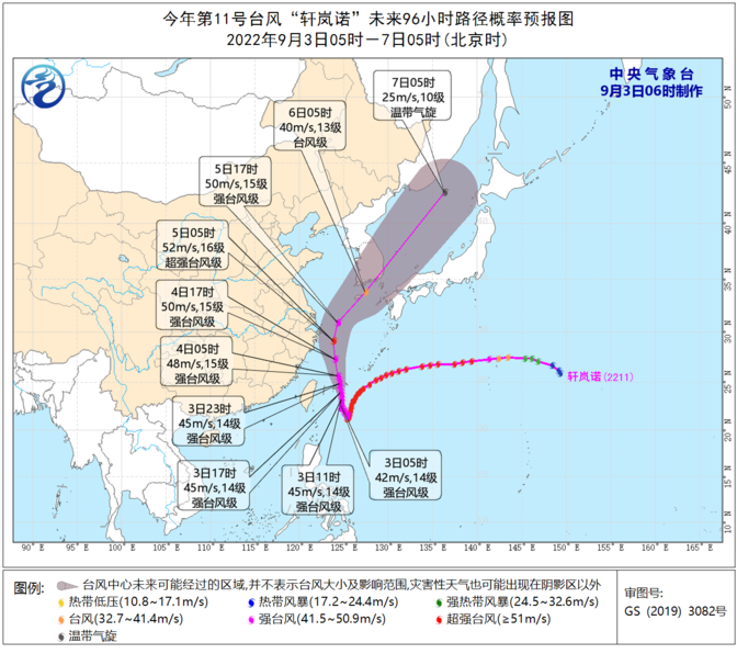
The typhoon "Xuan Lannuo" trajectory has a lot of exceptions, and it steps out of a "V -shaped" path on the sea. This phenomenon has also caused a heated discussion.
In this regard, Zhu Dingzhen told reporters that the trajectory of the typhoon "Xuan Lannuo" was abnormal, and a "rapid turn" appeared, which was mainly caused by the change of the guidance airflow.
"The trajectory of the typhoon is like playing a gyro game when I was a child. With a whip pump gyro, the gyro will turn in one direction; but by the internal force of the gyroscope, the direction of swing is uncertain, and it may be crooked." Zhu Dingzhen explained to the reporter like this. Essence
Specifically, before September 2nd, the entire subtropical high pressure was opened, showing a obvious belt. Therefore, the typhoon "Xuan Lannuo" walked west along the south side of the subtropical high -pressure, and even a south.

Typhoon "Xuanlan Nuo" path presents V -shaped picture source: China Meteorological Bureau
However, after September 2nd, a fault zone appeared in the high -pressure subtropical high pressure, giving the typhoon a passage north. At this time, the path of the typhoon "Xuan Lannuo" was guided by the airflow of the auxiliary high pressure northwest. Under the influence of these factors, the path of the typhoon showed the situation that was originally from the south of the west and later turned north.
Regarding the operating trajectory of typhoons in the future, China Weather Network released news that from the perspective of the path forecast of "Xuan Lannuo", it is still impossible to completely rule out its possibility of landing on the coast of East China.
It is expected that from the 3rd, "Xuan Lannuo" will move northward to move north, and move into the East China Sea on the night of the 3rd. The intensity will develop again and gradually approach the coast of the northeast of Zhejiang. On the evening of the 4th, it will move to the northeast around the sea of Zhejiang to the northeast, tending to the southern part of the Korean Peninsula to the coast of the area of Benshu Island, Japan.
"Xuanlan Nuo" may also return to the intensity of super typhoon
"Daily Economic News" reporter noticed that the current coastal provinces have been waiting for the typhoon "Xuan Lannuo".
For example, due to the influence of Typhoon "Xuan Lannuo", the Zhejiang Marine Monitoring and Forecast Center has issued a red alert at 16:00 on September 3.

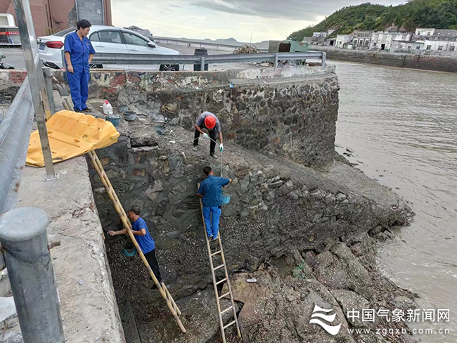
After receiving a typhoon warning, the staff seized the time to strengthen the work of the dock to strengthen the picture. Source: China Meteorological Bureau
Zhu Dingzhen told the reporter of "Daily Economic News" that although the chance of landing from the current typhoon "Xuan Lannuo" is relatively low, the typhoon is very large and strong. The data shows that the typhoon 10 wind ring radius is 120 radius 120 ~ 180 kilometers, the radius of the twelve -level wind ring 50 kilometers. It can be said that this is a very mature typhoon and may return to the intensity of super typhoons. And such a huge typhoon, even if it is not logged in, will affect the two or three hundred kilometers or even larger areas around the surrounding area. This also means that for East China coastal areas, we need to pay attention to preventing the impact of wind and rain.
According to the China Weather Network, from September 2nd to 6th, Taiwan ’s east, East China Sea, Hangzhou Bay, Yangtze River Estuary District, Yellow Sea in the south of the Yellow Sea, the coast of the central and northern part of Fujian, the coast of Zhejiang, the coast of Shanghai, the central and southern coast of Jiangsu The land will have 7 ~ 9 gale, and the gusts can reach 10-11 levels. Among them, Taiwan will be 10 ~ 13 in the southern ocean, the central sea area of the East China Sea, the Yangtze River Estuary District, Hangzhou Bay, Zhejiang coast, Shanghai coast, and southeast of Jiangsu. Dafeng, the nearby sea of the "Xuan Lannuo" center is 14 ~ 17, and the gusts can reach level 17 or more.
Daily Economic News
- END -
Notice!Jiangsu detected 7 batches of unqualified!

The reporter learned today from the Provincial Market Supervision Bureau that rece...
Master's interpretation 丨 former deputy dean of the Chinese Academy of Social Sciences Cai Yan: Promoting social flow is the key to building a shared society

Zhejiang News Client reporter Zhou YuhanThe 15th Party Congress of the Provincial ...