Typhoon "Xuan Lannuo" will be moved into the East China Sea China Meteorological Bureau to launch a three -level emergency response to the Chinese Meteorological Bureau tomorrow!
Author:China Meteorological Administr Time:2022.09.02
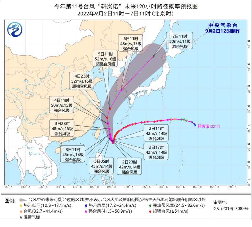
Typhoon Xuan Lannuo No. 11 this year
(Strong typhoon level) center
Today (September 2) is located at 9 o'clock
East of the south of Zhujiajian Island, Zhushan City, Zhejiang Province
About 980 kilometers of Taiwan on the east ocean
The largest wind near the center is level 14 (45 meters/second)
The lowest air pressure in the center is 950 Hill
Seven -level wind ring radius 240 to 280 kilometers
China Meteorological Administration on September 2nd
Start the typhoon third -level emergency response
Central Meteorological Observatory at 10:00 on September 2nd
Release typhoon yellow warning

Predict
"Xuan Lannuo" will first stagnate or rotate with the east ocean in Taiwan
Slightly weakened intensity
From the 3rd, it will move north to the west.
Move into the East China Sea at night on the 3rd
Strong development
It is possible to develop into a super typhoon again
And gradually approach the coast of the northeast of Zhejiang
4th to the morning of the 5th
It will move in the northeast in the northeast of Zhejiang
Trending to southern Korean Peninsula
Go to the coast of the area of Honshu, Japan

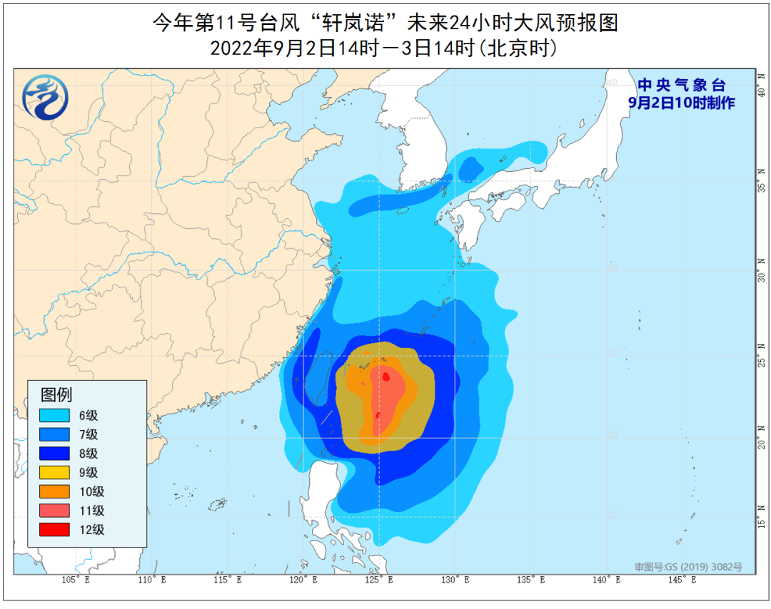
Dafeng forecast: From 14:00 on September 2nd to 14:00, the bus strait, Taiwan Strait, Taiwan's southern ocean, the south of the Yellow Sea, most of the waters near the Diaoyu Islands, the Yangtze River Estuary Area, Hangzhou Bay, and the northern and eastern parts of Taiwan Island, as well as the northern and east of Taiwan The coast, the coast of the central and northern part of Fujian, the coast of Zhejiang, the coast of Shanghai, and the southern coast of Jiangsu will have 6-8 strong winds, and the gusts are 9-10. Xuan Lannuo's "nearby sea is 13-15, and gusts can reach level 16-17.

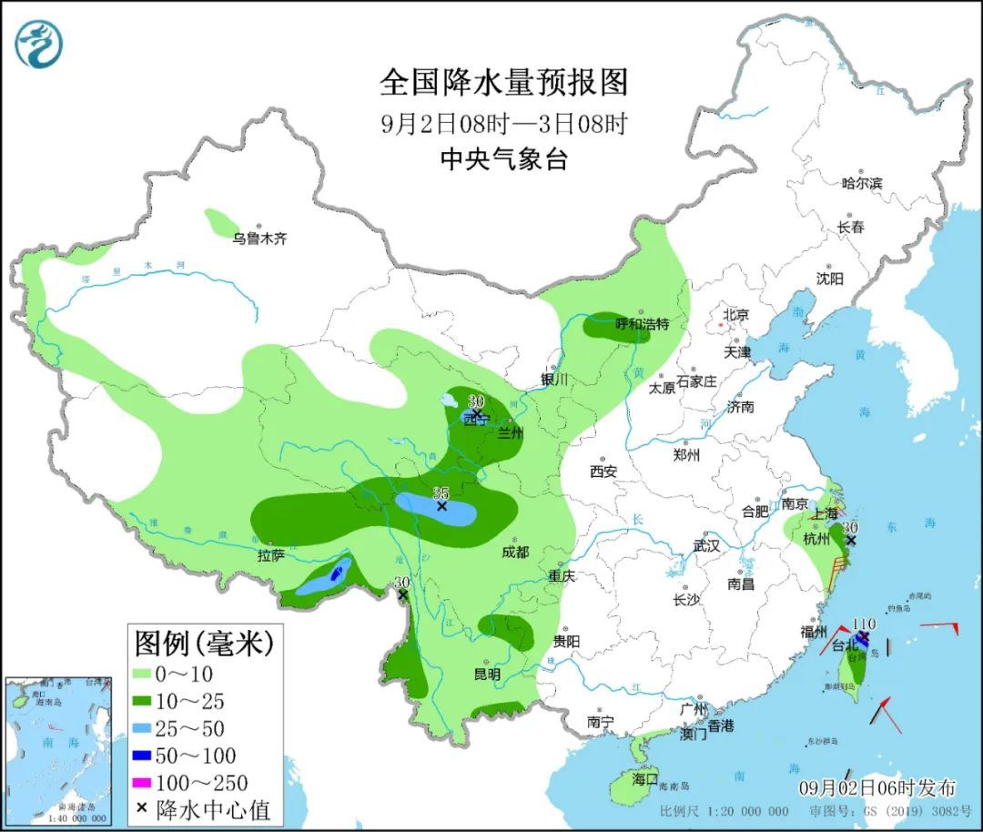
Precipitation forecast: From 14:00 on September 2 to 14:00, there will be medium to heavy rain in parts of the eastern part of Zhejiang, northern Taiwan Island, and other areas. Among them, there will be heavy rain in the northeast of Zhejiang. 110 mm).
Defense guide
The government and relevant departments do a good job of preventing typhoons in accordance with their responsibilities.
Related water operations and past ships should return to the port to avoid wind, strengthen port facilities, and prevent the ship's anchor, stranding and collision. Produced by China Meteorological Administration Xuanke Center (China Meteorological News Agency)
Source: Central Meteorological Observatory
- END -
Female tourists found "Stealing Films" in the toilet of the scenic spot?Scenic Area: It is infrared sensor

Ji Mei News Profile reporter Hu DikaiOn July 5th, a woman in Pingxiang, Jiangxi sa...
[Yihai Mingzhu Sea Overseas Chapter] Zhang Shuqi in California

In 2015, I retired, and I have time to visit museums around the world. During this...