The super typhoon "Xuan Lannuo" will affect the waters and other waters of China and the coast of East China
Author:Xinhuanet Time:2022.09.01
Xinhua News Agency, Beijing, September 1st. The reporter learned from the Central Meteorological Observatory that the typhoon "Xuanlan Nuo" No. 11 this year is huge and moved slowly. It is expected that it will affect the waters and other places of the East China and the coast of East China. The public needs to take precautions in advance.
It is expected that from the 1st to 6th, the East Ocean, the Bus Strait, the Taiwan Strait, the East China Sea, the Sea near the Diaoyu Islands, the Hangzhou Bay, the Yangtze River Estuary District, the Yellow Sea central and the eastern coast of Taiwan, the coast of the central and northern part of Fujian, the coast of Zhejiang The coast of Shanghai and the central and southern parts of Jiangsu will have 7 to 9 winds, and gusts can reach level 10 to 11. Among them, there will be 10 to 13 winds in the waters of the East Ocean, the central part of the East China Sea, and the waters near the Diaoyu Islands. The nearby sea surface passed by the center is 14 to 17, and the gusts can reach level 17 or more.
In terms of rainfall, it is expected that most of the Taiwan will have heavy rain or heavy rain on the 2nd to 4th, and there will be heavy rainstorms in northern Taiwan. The rainfall period is 3 to 4.
The meteorological department said that due to the conversion of summer and autumn and the adjustment of the atmospheric circulation, it is not certain that the possibility of "Xuanlan Nuo" has been completely ruled out or landed on the coast of East China.
【Edit: Li Yan】
- END -
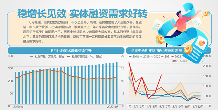
Recent financing recovery in June increased credit in June 2.81 trillion

On July 11, the central bank issued financial statistics data, social financing sc...
I have enough feeling of "things without response"

Every friend around me can talk about a lot of childhood emotions that have been i...