Typhoon "Mulan" landed!These places need to be vigilant
Author:Shanxi Evening News Time:2022.08.10
Around 10:50 on August 10, Typhoon Magnolia No. 7 this year landed in Xuwen, Guangdong. Affected by it, there are obvious wind and rain in Guangdong, Hainan, and Guangxi. The local area may stimulate strong rainfall. It is necessary to be alert to secondary disasters such as geological disasters and floods in small and medium rivers.
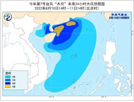
When the "Magnolia" landed, the largest wind near the center was 23 meters per second, level 9, and the lowest air pressure in the center was 992 hundred Pache. The intensity was a tropical storm. It is expected that "Mulan" will continue to move north at a speed of 20 kilometers per hour, and enter the North Bay on the afternoon of the 10th, and the intensity will gradually weaken.

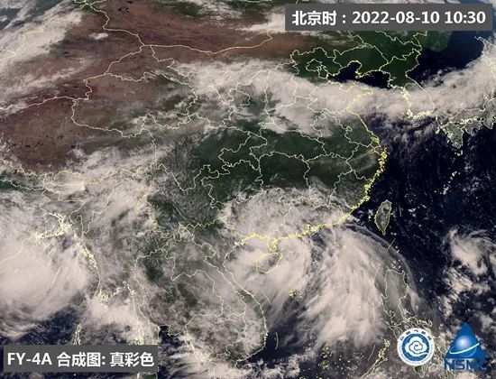
Typhoon "Mulan" was a satellite cloud map around 10:30 today. (Picture source: National Satellite Meteorological Center)
Typhoon Magnolia No. 7 this year was generated yesterday and was influenced by its peripheral circulation. In the past day, it appeared in parts of southern Guangdong, western Hainan Island, and north. Davided rainstorms; the coast of Guangdong, the coast of the northeast of Hainan, and the east and the west of the Dongsha and the Xisha Islands appeared 8-9 gusts, and the local area was 10 to 11.
Zhanjiang Maritime Safety Bureau reported that due to the influence of "Mulan", the Qiongzhou Strait Passenger Rolling Transport route was suspended from the entire line on the 9th. In addition, the Guangdong Zhuhai Port Bureau issued a notice today that the Lotus Bridge will be closed, and Hengqin Port will suspend the entry procedures for passengers from this morning.
The Central Meteorological Observatory predicts that due to the peripheral circulation of the typhoon "Magnolia", the South China coastal wind and rain are rushing. From three days from this day, there are heavy rain or heavy rain in parts of Guangdong, Hainan Island, central and southern Guangxi, and southern Yunnan. David rain; the central northern part of the South China Sea, the Beibu Gulf, and the Qiongzhou Strait will have 6 ~ 7 winds. Among them, the wind power of the nearby waters passed by the Typhoon Center can reach 8 ~ 9 and the gusts of 10 ~ 11. From the perspective of the rainfall process, today is the strongest time for rainfall. The rainfall in the above -mentioned areas will be significantly weakened tomorrow. Local need to pay attention to the possibility of disasters such as geological disasters, small and medium rivers, and flooding.


However, "Magnolia" also has a good side. For the continuous high temperature in South China, the wind and rain weather it brings will become "cooling tools", which will be cool to most South China. Among the provincial -level cities, there will be wind and rainy weather in Haikou, Guangzhou and Nanning. Today, the highest temperature will be around 30 ° C, feeling the "special version" cool.
According to Gao Xunzhu, the chief forecaster of the Typhoon and Marine Meteorological Forecast Center of the Central Meteorological Observatory, "Mulan" has the characteristics of large and strange paths. Because it is not completely separated from the monsoon low pressure, it maintains its huge volume and has a large impact. "The structure is loose. If you encounter suitable terrain, circulation and other conditions, you may stimulate strong territoriality rainfall and be vigilant.
Source: China Weather Network
- END -
Can the climate be investment and financing?Wuchang District National Pilot

On August 10, nine ministries and commissions such as the Ministry of Ecology and ...
China Space Power Power Station breaks the energy pattern and is no longer worried about electricity.

Space Power Station Imagination MapAs China proposed the theory of space power sta...