The effect of double typhoon cooling has expired, and the Yangtze River Delta "Sauna Sky" continues this week
Author:Xinmin Evening News Time:2022.08.01
The hot July is over
In August, he appeared in the fiery again
Last month
One of the most frequent words
I'm afraid it's hot
40 ° C high temperature frequently, winning the national high temperature list
Red and yellow orange warnings take turns in turn, high temperature "long online" in many places
Native

Three -voltage heavenly sweaty when you go out
I'm afraid there is only a typhoon that can bring cooling
Last week, Typhoon Sanda No. 5 this year
Typhoon No. 6 "Cui Si" has been generated one after another
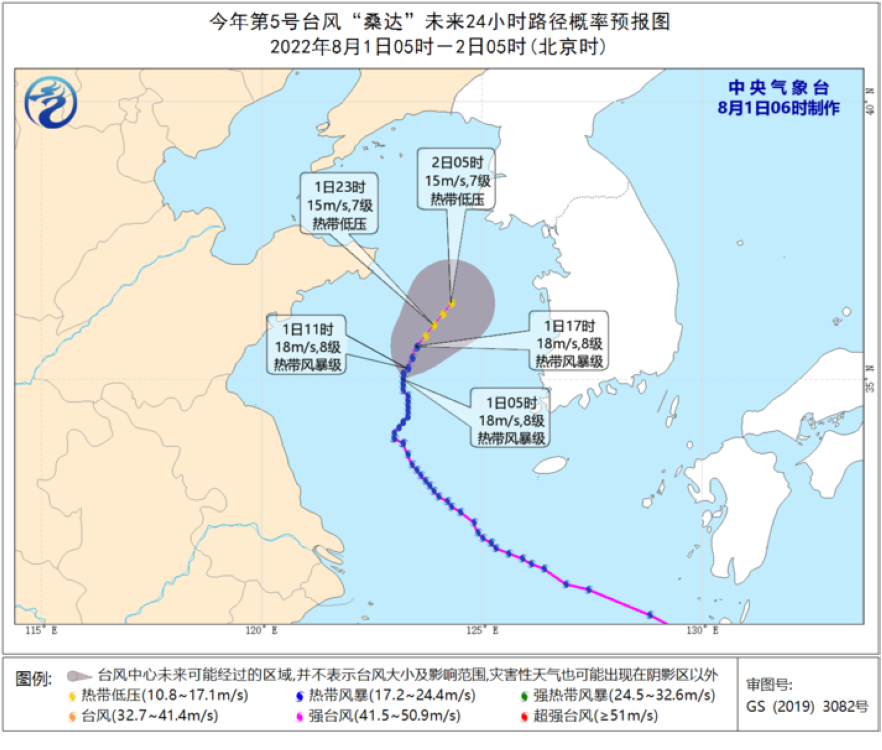
However, the typhoon "Sanda" is a bit "congenital", the spiral cloud is incomplete, the strength is weak, and the strength is insufficient. At present, the center of the "Sanda" (tropical storm) is far from the Yangtze River Delta region and comes to the south of the Yellow Sea of about 270 kilometers in the south of Shandong. It is expected that "Sanda" will slowly move north at a rate of 5-10 kilometers per hour, and the intensity will gradually weaken.
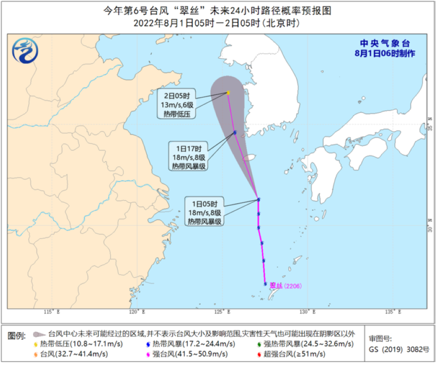
Looking at the typhoon "Cui Si" generated yesterday afternoon, its structure is more loose and the strength is weaker than "Sanda". This morning, the center of the "Cui Si" (tropical storm) is located on the northern sea of the East China Sea, about 250 kilometers east of Jeju Island, South Korea. It is expected that "Cui Si" will move north at a speed of 30-35 kilometers per hour, and the intensity will gradually weaken and dissipate, which may become the shortest typhoon in history ...
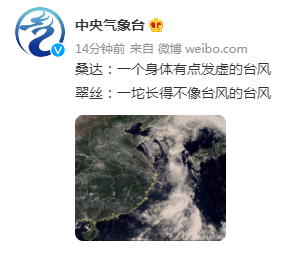
These two typhoons
to a certain degree
Weaken the subtropical high pressure
Give a little cool to the Yangtze River Delta
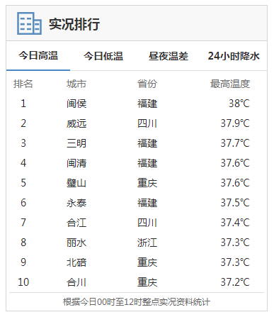
look! Today on the national high temperature list
At present, there is only one Zhejiang player figure
But "Sanda" and "Cuisi" did not completely block the high temperature
Typhoon away
The effect of cooling has expired
Side -tropical high pressure will counterattack
And the site will expand to the eastern part of my country and even the mainland of the central part
Use strength to prove who is the weather king of this summer

Yangtze River Delta
Want to exit the high temperature group chat!
Sorry, I can't help it ...

typhoon
From August 1st, the high temperature range expanded north. In southern North China, south of Shaanxi, Huanghuai, Jianghan and western Jianghuai, etc.
It is expected that during the day on August 1st, the southern Xinjiang Basin, southern Shaanxi, Hubei, Jiangnan, South China, eastern Sichuan, Chongqing and other places have high temperatures above 35 ° C. Among them, southern Xinjiang Basin, eastern Hunan, Jiangxi, southern Zhejiang, Fujian Fujian The highest temperatures in the west, eastern Sichuan, western Chongqing, northeast of Guangxi, and northeast Guangdong are 37-39 ° C, and the local area of southeast of Sichuan, southwestern Chongqing can reach 40 ° C. The Central Meteorological Observatory continued to issue high -temperature yellow warning at 06:00 on August 1.
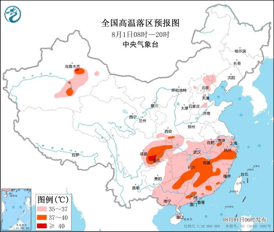
How is the high temperature in August different from July? Come and listen to the introduction of the Central Meteorological Observatory experts--
//
① The high temperature culprit from strong and strong to a family
The high temperature in July was jointly joined forces with high pressure in the Iranian mainland and opened in the south of my country, creating a long -lasting and extremely high temperature weather. In August, Iran retired from high pressure to the west. After the weaker typhoon left, the huge body of the Western Pacific deputy will go deep into our country again. Since then, the vice -deputy high -level control has controlled the widest range of mainland my country. ② In August, the prelude to "wet" was full of temperature last month. It mainly focuses on the high pressure of the mainland. The "dry goods" are mostly, and the stuffy sensation will be much less. The high temperature at the beginning of August was superimposed with "high humidity" BUFF. After the Northwest Pacific subtly high pressure was crowded by typhoons, it was not a rolling of the soil, but the "wet" came again -the sub -high will promote a large number of large quantities Water vapor at sea comes in. Taking today as an example, the relative humidity of most parts of the country will reach more than 80%, and in the next week, this high humidity will be maintained, and the Great Jiangnan North and South will enter the "sauna sky" model.
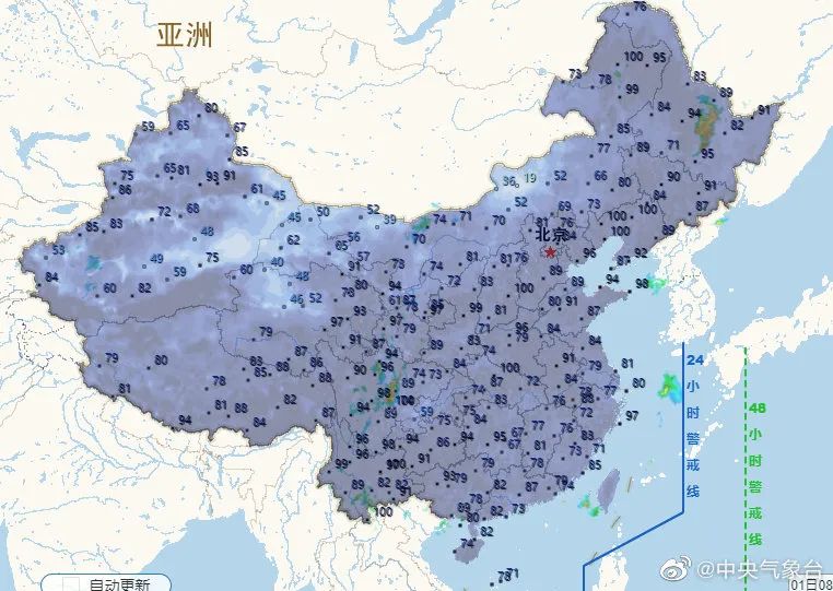
③ High -temperature Terminator -Northeast Cold Vortex? When is this round of high temperature? At present, after the 8th, the cold vortex of the Northeast will be lost to the south, and the high temperature in the north will weaken, but the high temperature in the southern area may still be maintained. However, this round of high temperature is not harmful to the South China, southern part of Jiangnan, and the southern part of Jiangnan, and even get a brief cooling. As for how long it will be cold, it depends on the performance of the follow -up typhoon.
"Seven up and eight and down" is usually a critical period for flood control in my country. From late July to early August, the rainfall nationwide is very concentrated, which is closely related to the very active typhoon during this period. However, compared with previous years, this year, the coast of Shanghai and Jiangsu and Zhejiang seems to have a typhoon atmosphere, not only the number of typhoons is small, but the intensity is not high.
Meteorological experts said that since the beginning of this year, the typhoon in the Northwest Pacific Ocean has been weak, which is related to the situation of the entire atmospheric circulation. The generation and strengthening of the typhoon requires two airflows to friction with close range. Generally speaking, the typhoon that affects my country is the Typhoon Northwest Pacific, which requires the continuous collision of tropical Dongfeng and southwest monsoon to continuously improve the intensity. Taking "Sanda" as an example, the area of Dongfeng this year is particularly large, and the southwest monsoon is very weak. The two cannot produce collisions, resulting in insufficient "Sanda" intensity.

Typhoon "Sanda" brings crystal sky
According to the mid -term forecast of the Central Meteorological Observatory, in the next 10 days, the tropical disturbance of the South China Sea and the Northwest Pacific has become active. It may be generated by 1 to 2 typhoons, which will have the impact of wind and rain on the sea area of the southeast of my country.
The Central Meteorological Observatory is also popular. The next typhoon name is Cuisei, and the next one is Mulan. I hope that the typhoon can "sensible", bring coolness, and don't hurt.
High temperature in early August is still very arrogant
It depends on the coolness of the clearness. It depends on mid -August
Everyone has to do a good job of heatstroke and cooling down

- END -
Nanhu New District: Effectively build a safe production defense line in the field of civil affairs

In order to further improve the level of production safety in the civil affairs fi...
Dunhua Meteorological Bureau lifted lightning yellow warning [III level/heavier]
The Dunhua Meteorological Bureau lift the lightning yellow warning signal.