"Sanda" just left, Typhoon No. 6 "Cui Si" was generated!High temperature return!The weather in Zhejiang next ...
Author:Voice of Zhejiang Time:2022.07.31
Source: Zhejiang Weather
The copyright belongs to the original author, if there is any infringement, please contact it in time
This "burnt" is full of July,
Finally, I want to draw a end!
August is about to open,
Please high temperature "merciless" ~

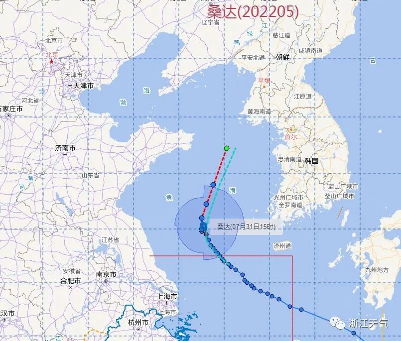
Around noon today, "Sanda" completed the turn in the middle of the Yellow Sea in my country and gradually stayed away from our province. Although it has insufficient strength and keeps "low -key" all the way, it has also weakened the arrogance of high -pressure tropical high pressure to a certain extent, and temporarily liberated us from the hot weather of 40 ° C+!
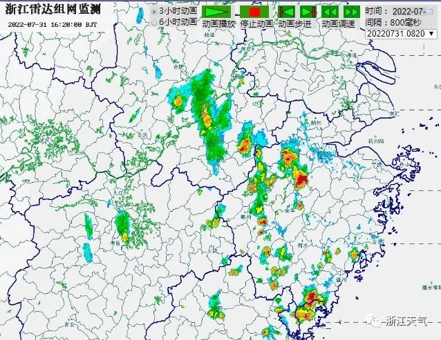
Affected by its peripheral circulation, part of the coast and northern Zhejiang region are sometimes shower or thunderstorms! In other areas, there are still more decentralized thunderstorms in the afternoon.
Provincial Meteorological Observatory was released at 16:00
From this evening to night: the coastal and northern Zhejiang regions are cloudy to overcast, and some of them sometimes have shower or thunderstorms; other areas are cloudy, and there will be decentralized thunderstorms in the middle of the night. There are some short-term rainstorms in the thunderstorm areas above the thunderstorm area. Be sure to strengthen prevention!
Tomorrow: Cloudy in northern Zhejiang and coastal areas, some shower or thunderstorms in the afternoon; in other areas, it is sunny and cloudy, and there will be decentralized thunderstorms in the afternoon.
The day after tomorrow: The coastal and southern Zhejiang regions are cloudy to overcast, with some shower or thunderstorms; other areas are cloudy, and there are decentralized thunderstorms in the afternoon.
In terms of temperature, as of 16:00, most of our province has been shrouded in high temperatures. Fortunately, the temperature of the 4 -character head has no attack; northern Zhejiang and coastal areas have not rushed over the high temperature line!
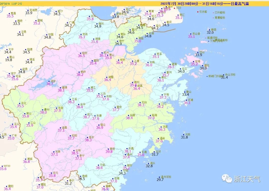
High temperature report
Due to the control of the subtropical high -pressure control, there will still be a large area of high temperature weather tomorrow on the day after day. Except for coastal islands and high-altitude mountainous areas, the highest temperature in northern Zhejiang and northern coastal areas will be 34-37 ° C in other areas tomorrow, 37-39 ° C in other areas, and local 40 ° C or more; ° C, above 40 ° C.
Relevant parties of Greek pay attention to heatstroke prevention and cooling work.

Hot and hot! We are looking forward to having a good typhoon to get a warm and warm! "Sanda" is not excellent, what about Typhoon Cui Si, which was generated this year today? I'm afraid there is nothing to expect ~
Typhoon
Typhoon Typhoon No. 6 this year (tropical storm, English name: trases; name Source: Cambodia; Name: Woodpecker) generated today (31st) generated in the afternoon (31st), at 14:00, it is located in Naha City, Okinawa Prefecture, Japan. On the west of the north, about 90 kilometers of ocean surfaces, 27.0 degrees north latitude, 127.5 degrees east longitude, the maximum wind near the center of the center (18 meters/s), the lowest air pressure in the center is 998 hundred Pache, and the seven -level wind circulation is 120-280 kilometers. Essence
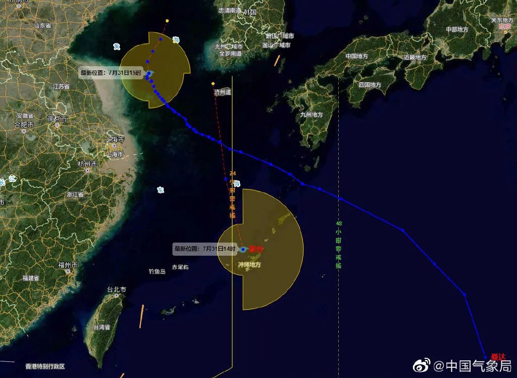
It is expected that "Cui Si" will move north to north of 126-127 degrees at a speed of 25 to 30 kilometers per hour. The intensity will not change much. After entering the waters of the Yellow Sea tomorrow afternoon, it will weaken and dissipate. Affected by it, today to tomorrow morning, there are 8-9 levels in the eastern sea of the East China Sea and 10 gusts. Please pay attention to the past ships. In addition, due to the weak strength of Typhoon "Cui Si", the history of life is short, and the cloud system is loose, it has no direct impact on the offshore and inland in our province.
Therefore, "The Word of the Hot" will continue to be the theme song of the weather in early August ~
However, there are also "picking up". On the 2-4th, the coast and southern Zhejiang region were affected by the low-altitude southeast airflow and weak concentration. Sometimes there were showers or thunderstorms, and high temperatures were eased! But the highest temperature in most other areas can still reach 37 ° C!
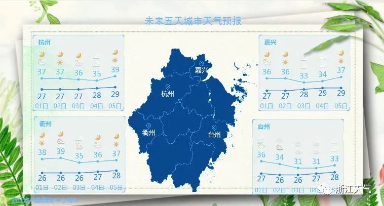
From the 5th, the high temperature range of our province will also expand, and the intensity will also increase! In addition to coastal islands, most of our province will accept high temperature crit at 37 ° C+, at which time the figure of 40 ° C+may be more!
Anyway, after all, it is still in the heat of the summer. Everyone should do a good job of heatstroke and cooling, and still not to relax!

- END -
Jiangmen, a city of civilization that integrates love into the blood

To a thank you letter from the friends of Guangda citizenDear citizen friend:Hello...
Jinan Flood Control and Drought Resistance Headquarters Office issued a notice of heavy rainfall prevention work

On July 22, the reporter issued an emergency notice on the prevention of heavy rai...