Typhoon "Sanda" is generated and moved into the East China Sea tonight!The next weather in Zhejiang ...
Author:Voice of Zhejiang Time:2022.07.29
Source: Comprehensive Zhejiang Voice Reporter Cai Jikang, Central Meteorological Observatory, Zhejiang Weather, China Meteorological Channel Meteorological Analyst Xinxin, Ningbo Evening News, etc.
The copyright belongs to the original author, if there is any infringement, please contact it in time
Typhoon No. 5 this year "Sanda"
It was generated last night!
Two days after the Ming Dynasty, as "Sanda" approached
The coast of East China will be affected by wind and rain
What is the development of typhoons in the future?
latest news
Typhoon Sanda No. 5 this year (tropical storm, English name: songda; name source: Vietnam; Name: northwestern Vietnam) was generated yesterday night, the center today (29th) at 5 o'clock in the morning (29th) at 5 o'clock in the morning (29th) at 5 o'clock in the morning (29th) Located on the ocean surface of about 880 kilometers east of Naha City, Okinawa Prefecture, Japan, it is 26.4 degrees north latitude and 136.5 degrees east longitude. The maximum wind near the center is 8 (18 meters/s), the lowest air pressure of the center The wind ring radius is 120-180 kilometers.
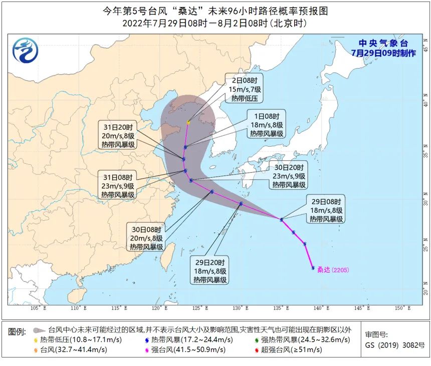
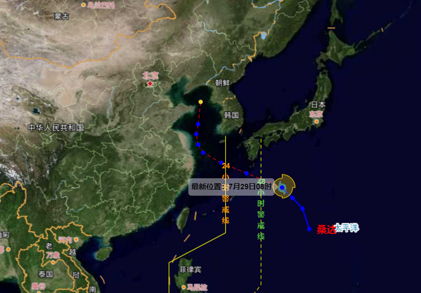
It is expected that "Sanda" will move north to north at a speed of 40-50 kilometers per hour, and the intensity will not change much. It will move into the East China Sea on the night of the 29th. Gradually weaken. From July 29th to August 1st, there are 6-8 storms in the northern part of the East China Sea and the south of the Yellow Sea in my country. The nearby sea across the typhoon center has level 9 and the gust of 10 gusts.
Affected by it, from July 30th to 31st, there were 8-9 levels in the northeast of the East China Sea and 10 gusts. Please pay attention to passing ships. In addition, due to the asymmetric structure of the typhoon circulation, the main rainfall area is on the northeast side of the typhoon. "Sanda" has a small impact on the rainfall in our province. Among them, the 30th to 31st will have partial to large parts of Zhoushan, Ningbo, Jiaxing and other places. shower.
Because the atmospheric circulation adjustment is large at the end of July to the beginning of August, especially the effects of the position and intensity changes of the subtropical high pressure on the path of "Sanda" still have certain uncertainty. In addition, in the future, a period of active typhoon will be entered, and the Provincial Meteorological Observatory will closely monitor, strengthen analysis, and report in a timely manner.
&&&
Whether Sanda landed in my country still has suspense
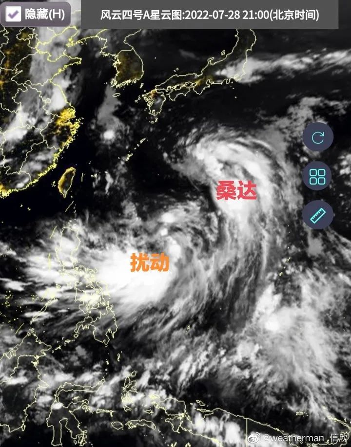
Xinxin, a weather analyst at the Chinese Meteorological Channel, said that the current disturbance of Typhoon 95W and the subtropical high-voltage form on the 31st have made whether the future typhoon Sanda landed in my country. There is still suspense. period.
my country's official forecast paths are not available. European and American collection forecasts, European values have weakened westward to the north, and more members of the United States think they will land in East my country in China. At present, the situation is still not very clear, and the formal evolution of typhoon intensity and deputy high in the later period.
The 95W on the south side of Sanda also interfere with the development of Sanda. In the future, there will be a chance to develop into a typhoon. There are also numerical forecasts that the 95W will be integrated with Sanda in the future. In short, the typhoon variables are large in the future and need to be continuously tracked and revised forecast.
&&&
Netizens from Jiangsu, Zhejiang and Shanghai:
The wind is too strong, just the rain is enough


&&&
From the beginning, start to cool down!
Today (July 29)
Our province still has a large range of high temperature weather
Cloudy along the coastal area
Sometimes there are shower or thunderstorms
It is clear to cloudy in other areas
There are thunder showers in some yin in the afternoon
Except for coastal islands and high -altitude mountainous areas expected
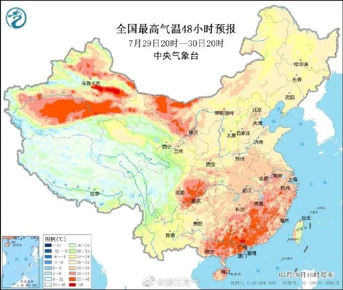
The highest temperature in northern Zhejiang and coastal areas is 35-37 ℃
37-39 ℃ in other areas
Local 40 ° C above
Tomorrow (July 30)
Cloudy to yin in coastal areas
Some showers or thunderstorms
It is clear to cloudy in other areas
There is decentralized thunder shower in the afternoon
Good news is finally coming!
High temperature is about to be relieved
With the subtropical high -pressure eastward retreat to the north lifting
The high temperature range and intensity of our province will decrease
Tomorrow (July 30)
The highest temperature is expected to stop temporarily below 35 ° C temporarily
Even if the temperature rises again
The possibility of 40 ℃+extreme high temperature is less likely
Look at the temperature
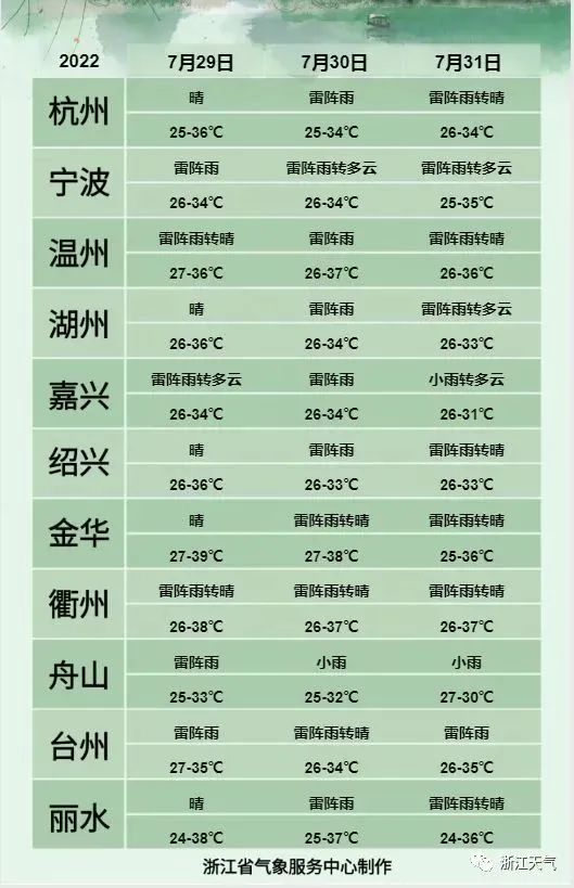
- END -
"Five -entry" service development tentacles extend the grassroots level
Jian'an Community's housekeeping service outlets are under construction. Huaibei Huiping Housekeeping Service Center is about to enter. At that time, community residents can scan the code 'order' and...
"Flower Economy" under Qilian Mountain

This is the rapeseed flower field shot in Menyuan Hui Autonomous County, Haibei Ti...