Go to the ice layer of the North Pole, listen to the sound of the Arctic Ocean, explore the slowest expansion of the ocean ridge | Wei Yanhua
Author:Institute of Geological Earth Time:2022.09.24


In addition to these difficult and heavy scientific research work,
We can also see the beautiful scenery,
There is also a fiery life.
Researcher of the Institute of Voice of the Chinese Academy of Chinese Academy of Sciences
Gezhi Campus 25 | July 8, 2022 Beijing
Hello everyone! I am Wei Yanhua, from the Academy of Sciences of the Chinese Academy of Sciences. Today I will share with you the story of my and the Arctic Ocean- "Hear the Blossom Arctic Ocean". Because I heard the sound under the ice under the Arctic Ocean, I saw the strange light on the ice, and I also experienced "jasmine blooming" in the Gick Ocean ridge.
When it comes to the Arctic region, national defense security is a topic that cannot be bypassed. During the Cold War, the United States and the Soviet Union deployed many nuclear submarines in the North Ocean Ice. Because the Arctic Ocean area is the best sea area for deploying nuclear deterrence -most major countries are distributed in the northern hemisphere, and most of the population is also in the northern hemisphere. The Arctic Point is more than 5,000 kilometers away from Beijing and Washington, only more than 3,000 kilometers from Moscow. From somewhere in the northwest of our country to the capital of other major countries, it is much farther, to more than 5,000 kilometers in Moscow, and 13,000 kilometers in Washington.
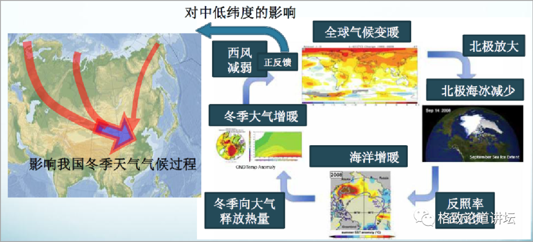
After the end of the Cold War, the importance of the Arctic Ocean has not decreased. Because of the reduction of sea ice caused by global warming, it has formed positive feedback on climate warming, which has a great impact on the entire global climate and the future of human beings. Therefore, the Arctic Ocean has become an area we have to study. The scientific community is facing a new Arctic.
What do you want to do?
Completed: 10%///////////
If you look at the earth, we can see that the Arctic region is the mainland around the ocean, and the Antarctic area is the ocean around the mainland. To study the ocean is inseparable from acoustics. Compared with electromagnetic waves and light waves, the attenuation rate of acoustics in water is the smallest. It can transmit long -distance underwater, and some sounds in the experiment can even go around the earth for a week. The earth is 40,000 kilometers a week, and it can be imagined how far the distance it spreads. Therefore, under the water, the sound is a means of information dissemination that can be used and more convenient.

Left: "Dragon" No.
Middle: "Deep Sea Warriors" to the right: "Struggler"
For example, these countries on the figure: "Dragon", "Deep Sea Warriors", and "Struggler", there are many acoustic devices.
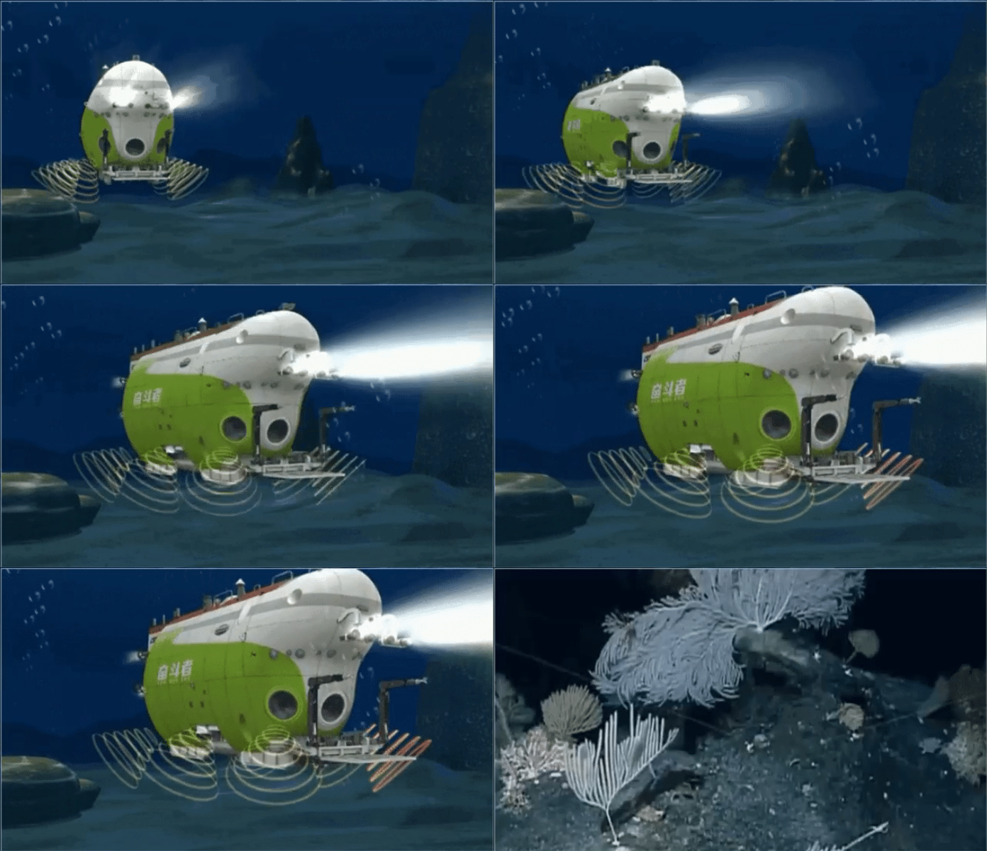
There are many sonar devices on the "Struggler". What is Sonar device? It is the abbreviation of sound positioning, navigation and ranging. In this moving map, you can see the water acoustic communication machine with the water surface on the "Struggler"; the high -resolution of the high -resolution of the ground terrain and the landform of the underwater terrain is detected; Sonari; Doppler speed measuring instrument that tracks acoustics under the sea; and in order to ensure its safe ultra -short baseline positioning sons, the deep submarine can be located on the water surface.
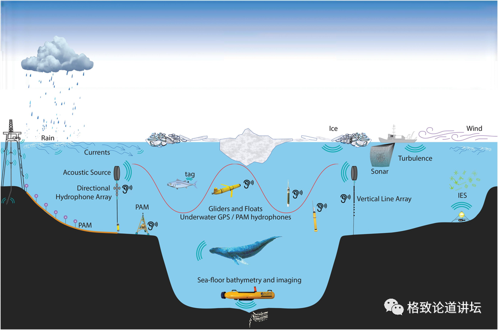
The content of polar water acoustic research is the characteristics of noise, baseline, the acoustic level of the entire marine waters, as well as the detection, positioning, navigation and communication methods of underwater targets. This is preparing for the needs of national shipping and resource exploration, and for the exploration and development of the ocean.
The picture above tells the observation network under the Arctic Ocean, and you can use acoustics to monitor the noise from the ice. You can know if the iceberg has melted, whether it is cracking, and what its change process is. Including the positioning and navigation of underwater robots, and what kind of route to guide it, and what kind of exploration it is needed, acoustic science needs to be guided.
my country's polar water acoustic science began to be relatively late, probably in 2014, Academician Li Qihu set his sights on non -traditional safety in the maritime field, such as terrorism, safety accidents in the process of shipping. Therefore, Academician Li suggested that we study the marine environment of the Arctic Ocean and its adjacent areas. In 2016, I participated in China's seventh Arctic Scientific Examination, and my colleagues in the water of the water also participated in some Arctic Scientific Examinations. 2021 is the 12th Arctic Science Examination, and I also participate in it.
Snow Dragon

During the polar scientific examination, you need to rely on the ice boat. There were many early icebreakers, such as the earliest "Oriental Red" and "Xiangyang Red" subjects produced by my country. Later, in 1995, I bought the "Snow Dragon" ship. The "Snow Dragon" ship could break 1.2 meters thick ice and 0.2 meters of snow.
Sherong No. 2
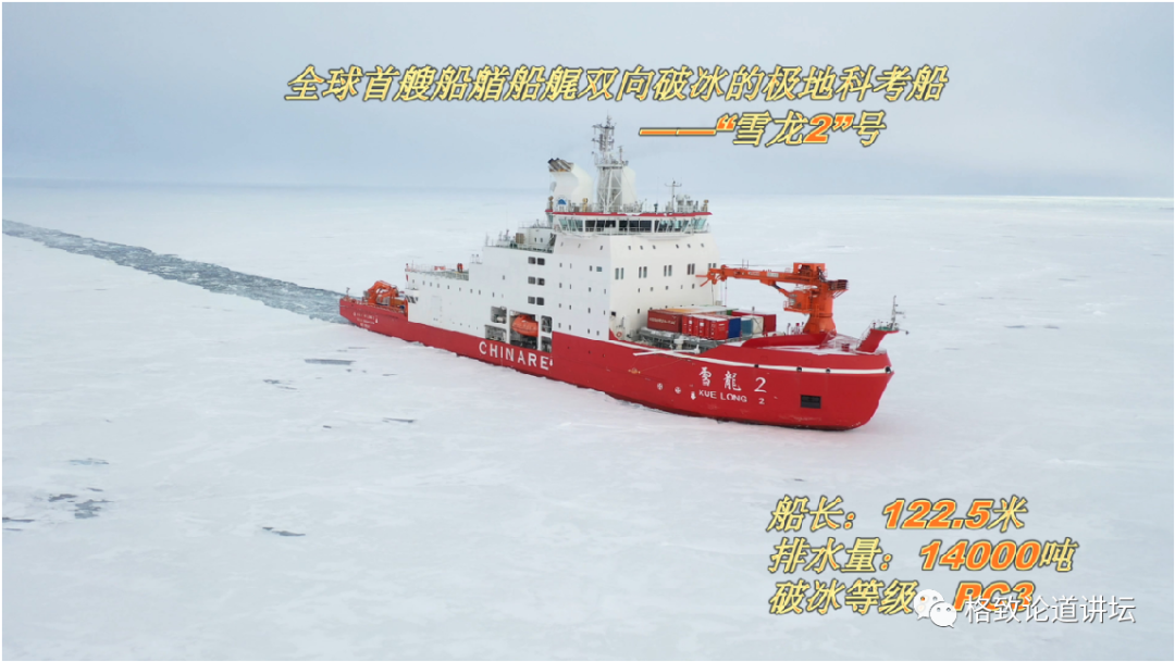
In 2018, the "Snow Dragon 2" produced by my country was laid off, and then he was put into the North and North Pole Science Examination. At present, the "Snow Dragon 2" is the main vessel of the North and South Pole Science Examination, which can break the 1.5 -meter -thick ice layer and 0.2 meters of snow.
Why introduce the thickness of the snow alone? In fact, snow in the polar region is different from the snow we usually see, it is very hard. In addition to the icing of the Arctic, except for the icing of the sea water, the rest is the layer of snow.
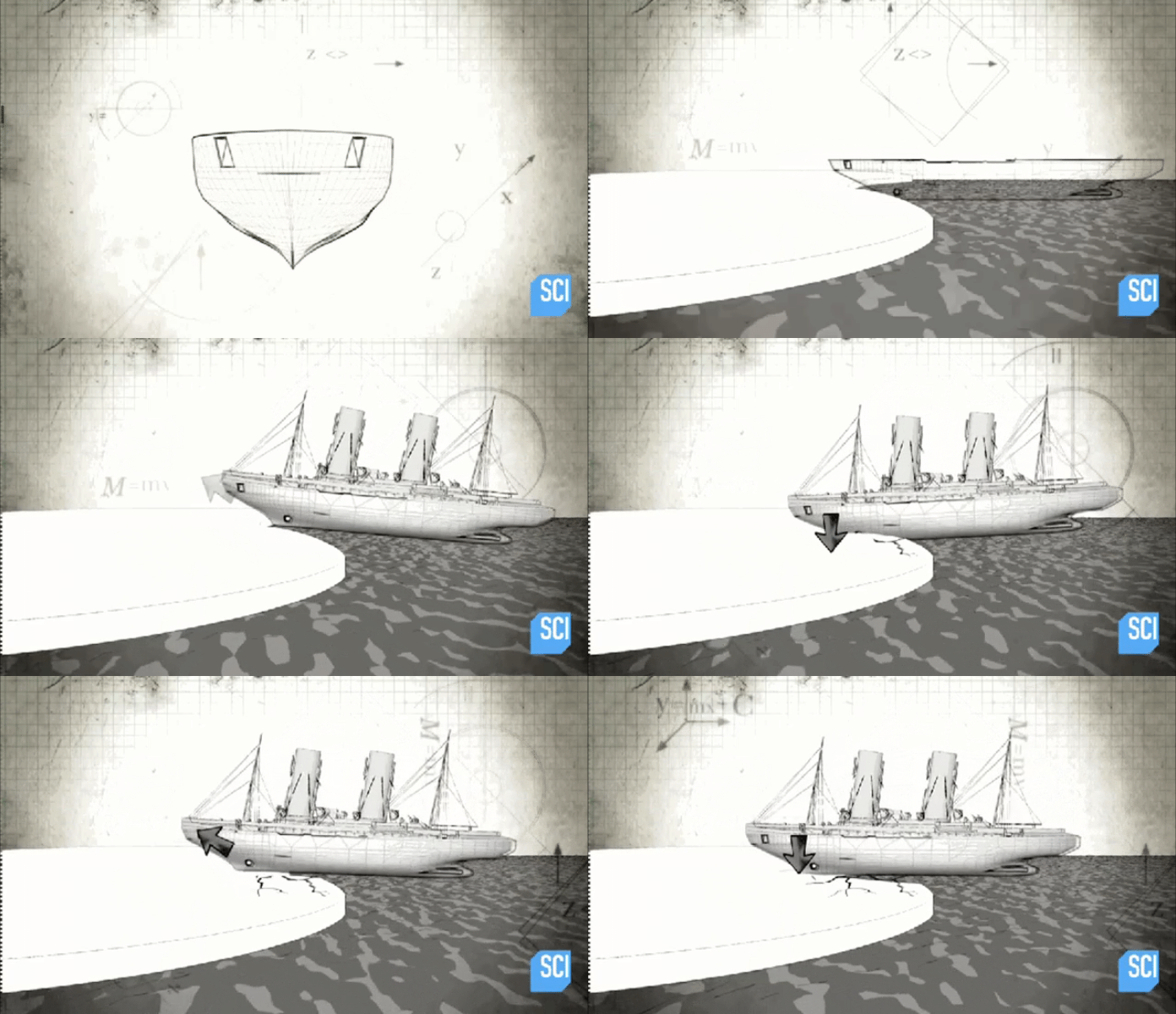
This is a moving picture of the ice -breaking ice boat. There are three ways to break ice: one is continuous, the other is a collision type, and the other is a swing type when the ice is particularly thick. Do you know what a swing is? It is very similar to the condition of pulling radish. When the ice -breaking boat is usually broken, it is not smashed by we imagined. In fact, it depends on the special structure of its tadpoles. The ice is crushed through the weight of the ship. Only in a thick ice place can it collide continuously. When the boat is stuck, the pressure carrier will be adjusted from the left to the right, and the right side is adjusted to the left.
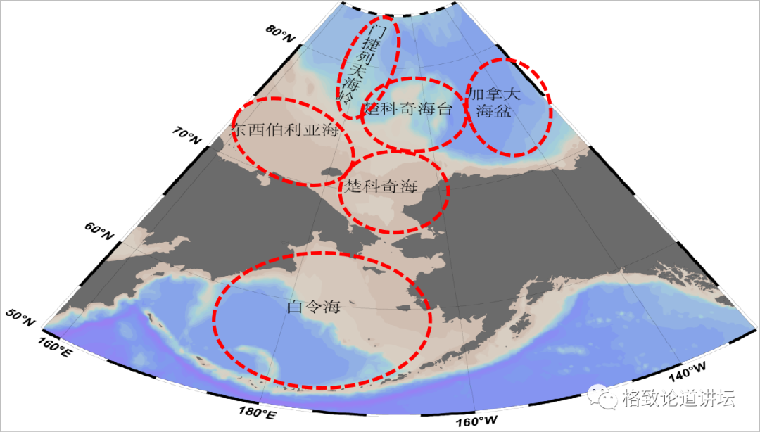
The 12th Arctic Science Examination: Target Garker Ocean Circart
Completed: 20%///////////
In 1995, my country participated in the Arctic Science Examination for the first time because of this scientific investigation that my country participated in the Peking Oceanic Council that year and became a member of the 15th Council. In 1999 and 2003 In 2008, three Arctic scientific investigations were conducted. In 2004, my country established the first continuous observation station in the Swarbard Islands -Huanghe Station. 2016 is the seventh time, mainly in investigation of physical, ocean, geology, chemistry, biology, meteorology, sea ice and other investigations.
The main areas of the first 11 times of the Arctic Science Investigation are the Bai Ling Strait, Chukica Sea, Chukica Sea, the East Siberian Sea, Menjiev Neva, and the Canadian sea basin and other areas. Everyone may pay little attention to these areas because they are too far away from us.
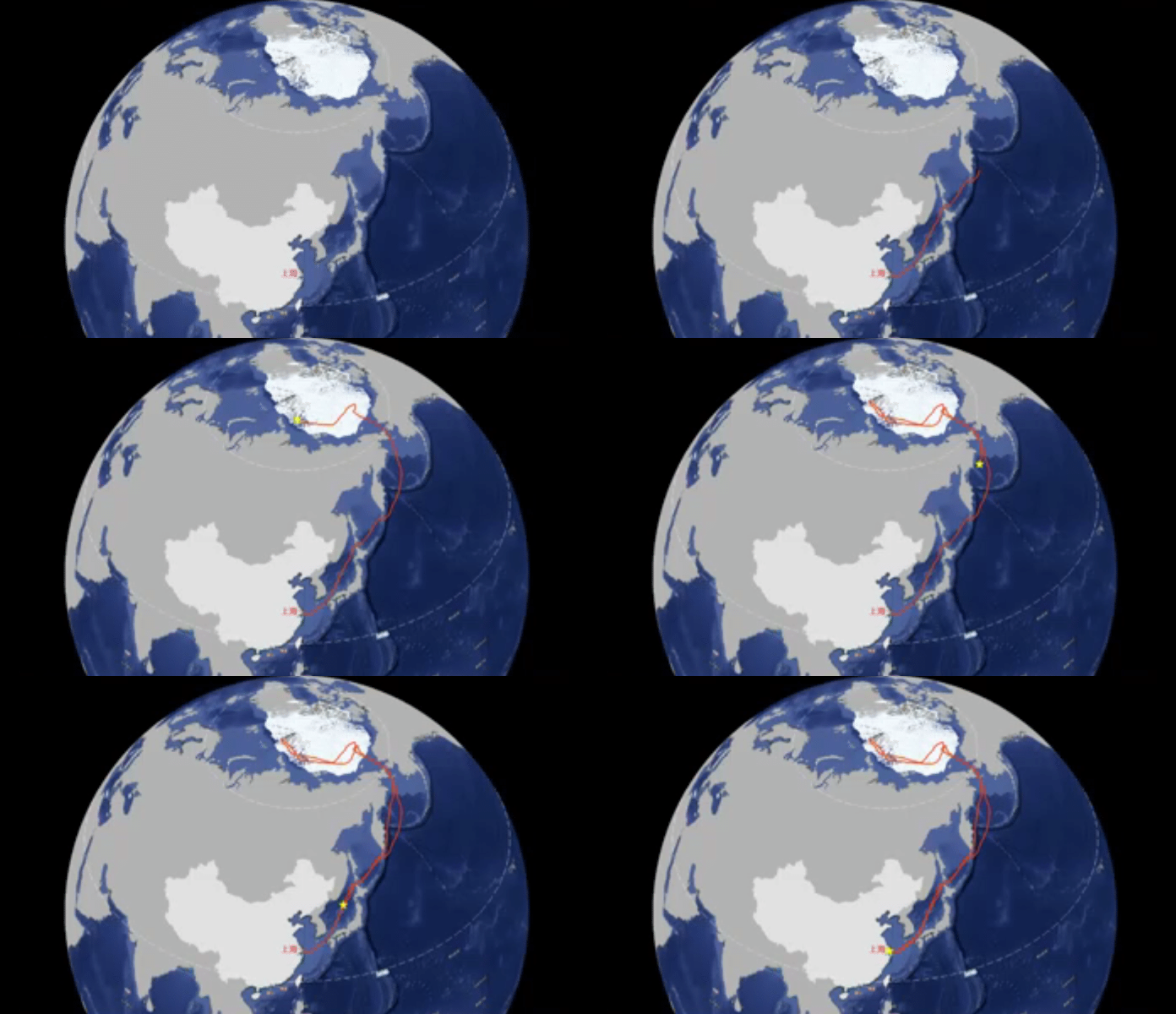
This is the 12th time of the Arctic Scientific Examination. We set off from Shanghai, all the way north, after the Malaysia Strait, the Strait between North Korea and Japan. Then passed through the Japanese Sea, walked east of the Tsangura Strait, and entered the Sea of Ehiek. Going forward to the southernmost tip of the Khaca Peninsula, crossing the Kanshaga Peninsula and entering the North Pacific. After passing the Alexian Islands and entering Bai Linghai. The Bai Ling Strait is very narrow, and the narrowest place is only a few kilometers. Our ship passes through the middle and enters the Arctic Circle. The Arctic Circle is just near the Bailing Strait, so after the Bailing Strait is equivalent to entering the Arctic Circle. Then inspected in Chukica Haitai, the Eastern Siberian Sea and other places.
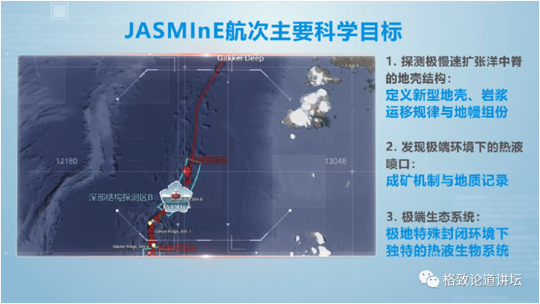
Unlike the previous several times, the 12th Arctic Science Investigation also went to the Garker mid -ridge, so it was also called the Garker October's deep spine detection plan. Its abbreviation is Jasmine, which is exactly the abbreviation of jasmine.
There are three main scientific targets of Jasmine voyage: the crust structure of the polar expansion of the ocean and middle ridges, and the hot liquid spray port in extreme environments, and the accompanying extreme ecological environment.
Schlindwein et al., 2007; Jokat et al., 2003
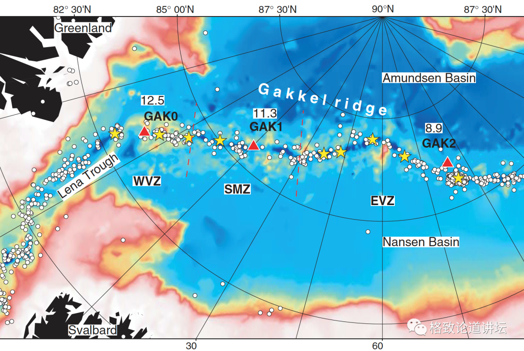
Why go to these places to explore? Because the Gick Ocean midpoint is the slowest expansion rate in the world. Scientists from all over the world have studied at the ocean ridges of various expansion rates. It is only a blank place in the Gick Ocean ridge, because it was completely covered by ice.
Other countries have organized five earth physical voyages, mainly concentrated on the Atlantic side of the east of 90 degrees, and east of 90 degrees east longitude. It is completely blank.
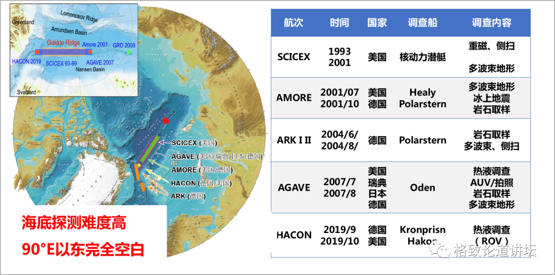
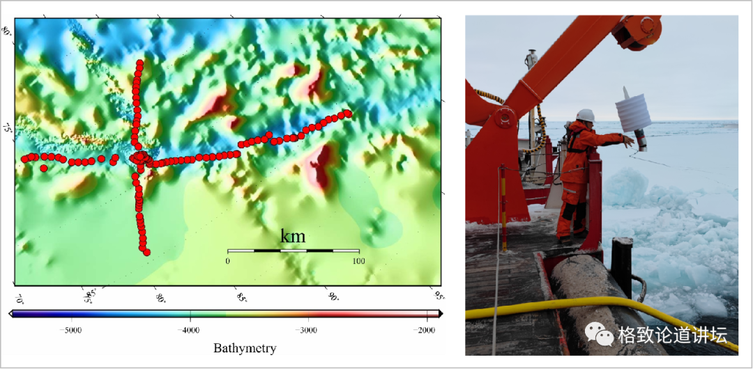
The red dot on the picture is the area we are going to -Gickya mid -ridge, which is 85 degrees north latitude and 85 degrees east longitude. And this detection is a large -scale detection voyage. The previous voyages are mainly targeted at rock science. In this voyage, rock sampling, multi -beam terrain, and AUV (autonomous submersible) all means all these methods we use. It's right.
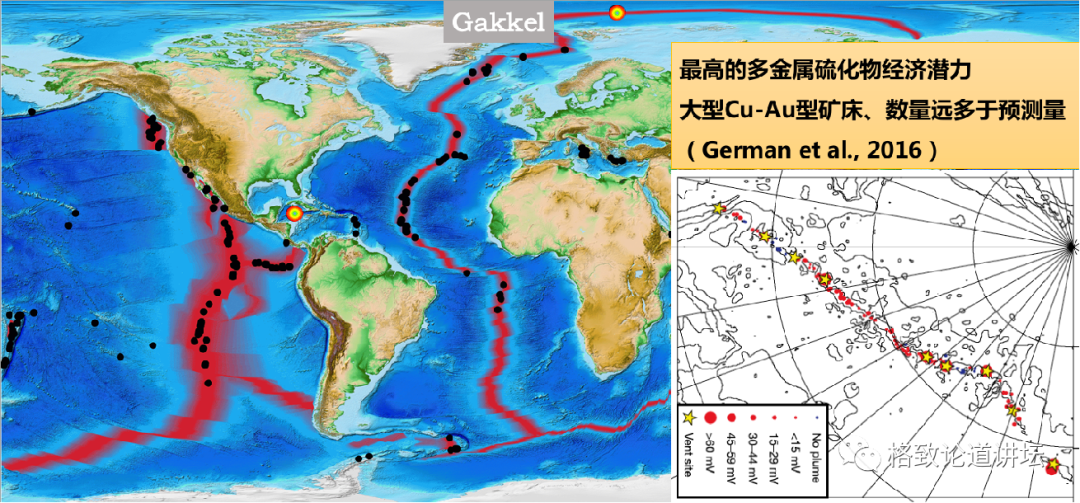
The other is to detect thermal fluid abnormalities in the Arctic Ocean. Previously, a large amount of thermal fluid abnormalities were found four times in the Arctic Ocean's hot fluid detection, but only one thermal jet was found. The relationship between the hot liquid spray port and the submarine is very important, so this is also the focus of research.
The Chinese have never been to the Gick Ocean ridge before. So we did a lot of ideas before going: what is the climate of this place? What is the wind speed? In order to detect the smooth development of the plan, we thought a lot of ideal state. For example, the wind speed should not exceed level 7 and the coverage of ice is best 50 % to 60 %, so that the experimental plan can be carried out smoothly. But after we arrived at the scene, I found that the ice base in the ice area of this place is more than 80%or more, and more than 50%is 10%ice. What is Shicheng Bing? The eyes are all ice. In the previous past Arctic scientific investigations, such as on the side of Chuki Sea, it was necessary to find ice at low latitudes and then conduct experiments on ice. But when the Gickye birch ridge, we found that there is no need to find ice anymore, because there are ice everywhere. And each piece of ice is particularly thick, and you can go up to conduct experiments directly. What is really difficult is to find Bingjie Lake and distribute equipment and underwater robots.
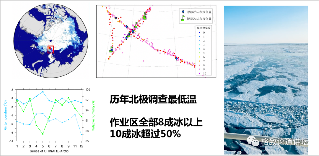
At the same time, the temperature in this place is particularly low, and it is the minimum temperature of the Arctic scientific research. Although it is only less than minus 9 degrees to minus 10 degrees, but because the air humidity is high, its physical temperature will be very low. When we did experiments, we put everything we could wear, but sometimes I felt cold.
Difficulty experimental process
Completed: 40%///////////
After arriving at the ice station, the first thing is to hang the equipment from the boat and start experiments.
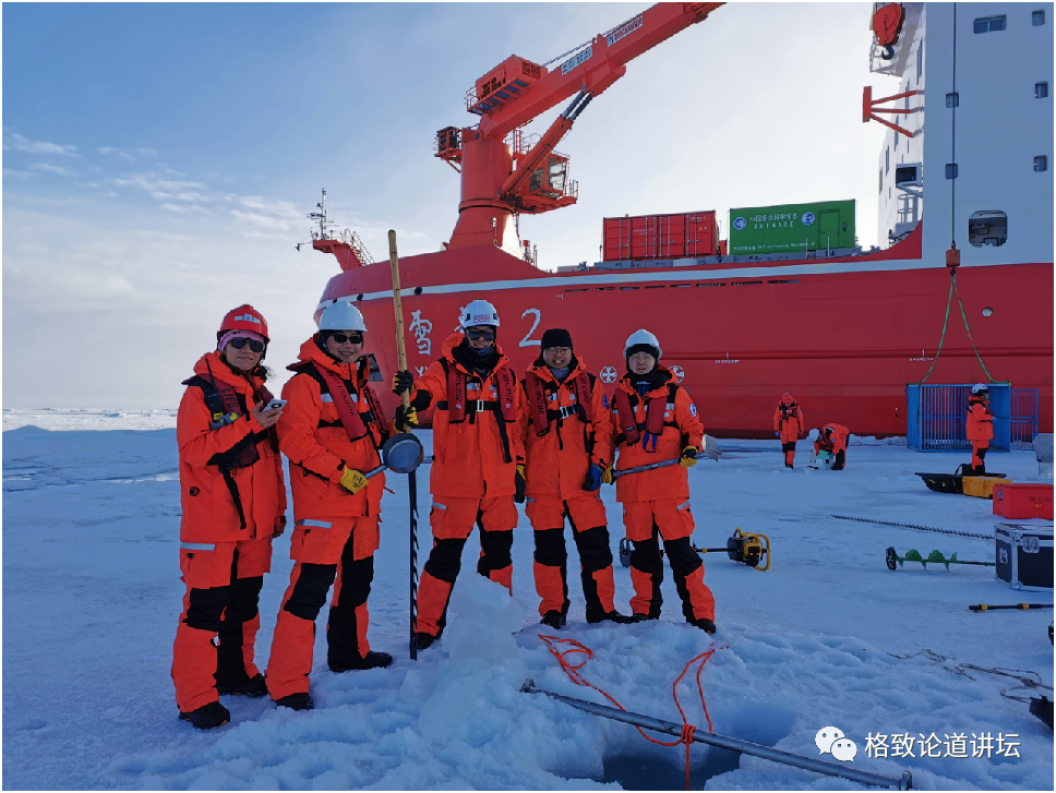
This is the experimental scene of our acoustic science. On the left, you can see an ice hole for experiments that are equipped with equipment. The picture is also all members of the acoustic group.
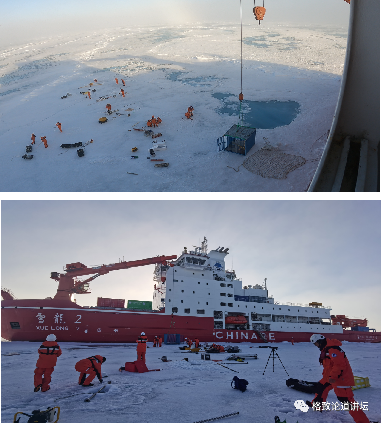
When it comes to ice caves, it should be said that the ice hole on the first ice station is the most difficult ice hole in the 12th Arctic Scientific Examination. This video is the process of hitting the ice hole. Why is this ice hole difficult to fight? Because the experiments on this ice station are to put some special shapes with special shapes to detect the situation of the return of it under ice. The size of this ice diamond is 25 cm, but our equipment is far more than 25 cm. So we designed to make 4 ice holes and put this thing down.
In fact, in the process of playing, the first ice hole was smooth, and the second ice hole was not smooth because it was empty. When it is empty, the rotating machine will rotate to one side underneath. After we finished four, we found that we couldn't let go, so we had to continue to fight, and the last 7 ice holes were hit.
In addition, we also used manual ice diamonds, saws, and even the hedge in my hand to fish up the ice. Because you can't see what is the situation without getting it up. While fighting, scoop the water inside, so it is very heavy. And the core area of the Arctic Ocean is near the Gick Ocean, and its ice is very thick. After we finished playing, the measured ice was about 1.7 meters. In the process of playing, we must pick up the pole, and rely on manpower to get the water in the ice cave up, so I am tired. When we were resting in the middle, everyone was paralyzed to the ground, and we didn't want to move at all.
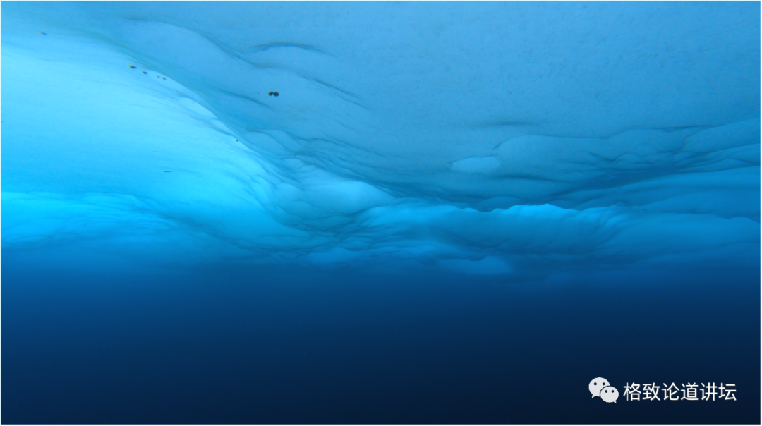
This is the situation where the Arctic Ocean has many years of ice. What are the characteristics? The ups and downs are relatively smooth, but at the same time it has a violent ups and downs near the ice ridge. The form under ice is very meaningful for acoustics, because it will bring additional reflection and dissemination losses to acoustic science.
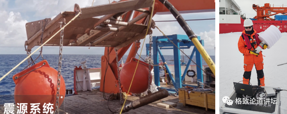
All the devices used in the deep spine detection of the Gick Ocean are domestically produced equipment with independent intellectual property rights, such as the shock system on the left, and the sonar buoy holding in my hand. Sonaron buoy is actually the receiving device of the underwater sound. It has a water hearing device underwater. When it is distributed, it will automatically expand to the depth of the underwater preset. There is a radio launch device on it. You can pass the data received in real time to pass the data received in real time. Back to the plane or on the ship. This time we got the data under the ice in real time on the boat.
The shock source system is mainly air guns. The air gun is pressed in the air chamber and added to a high pressure. Then spray the two muzzles of the air gun, which is equivalent to the vigorous release of energy. It can simulate artificial earthquake sources and can also be used as acoustic sources of acoustic experiments. This is the launch of theNon buoy, and we put a total of 120 pieces. 108 of them have signals, and the remaining 12 are invalid. Because the ice is too thick, it may be thrown on the ice, and then the ice cuts the cable underneath, so there are 12 only radio signals and no water sound signals.
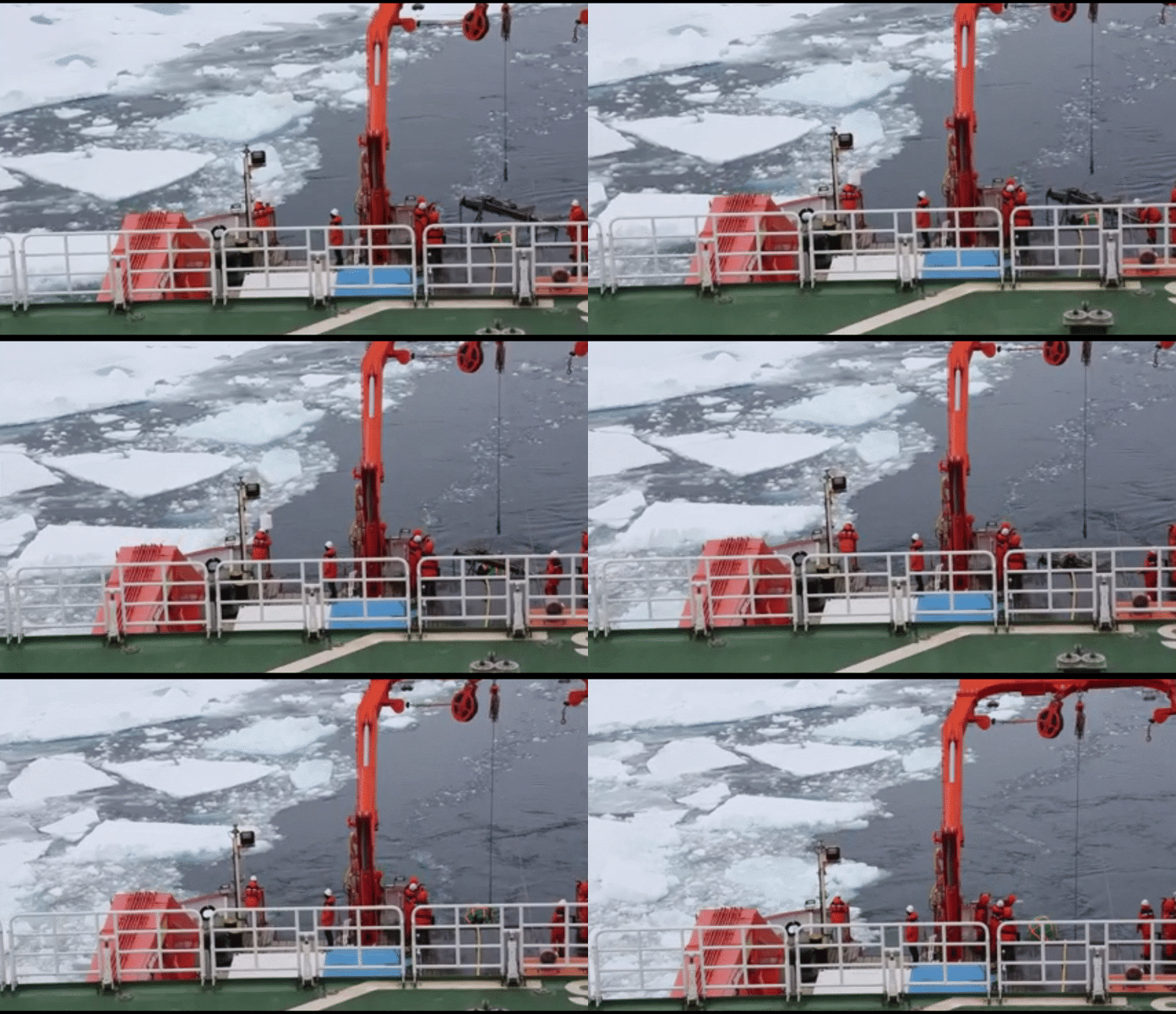
This is a video of throwing Sona buoyant. The white on it is an anti -ice cover, which is used to protect the airbags of the water surface. The role of airbags floating and expanding antenna. However, because there are many ice in the area, just broke the ice in front, and the ice behind was surrounded. So sometimes squeeze the sonar buoy to the ice and cannot receive the signal.
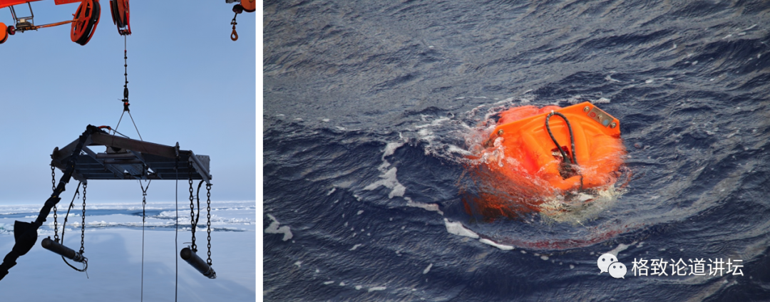
This is our main scientific equipment. On the left is a air gun, the right is OBS, which is the submarine seismometer with a vibrating sensor and a water hearing device on it. It can receive earthquakes simulated by natural earthquakes or artificial earthquake sources to analyze the underwater situation.
OBS voted a total of 43 pieces and successfully recovered 42. I was very fortunate to participate in this process.
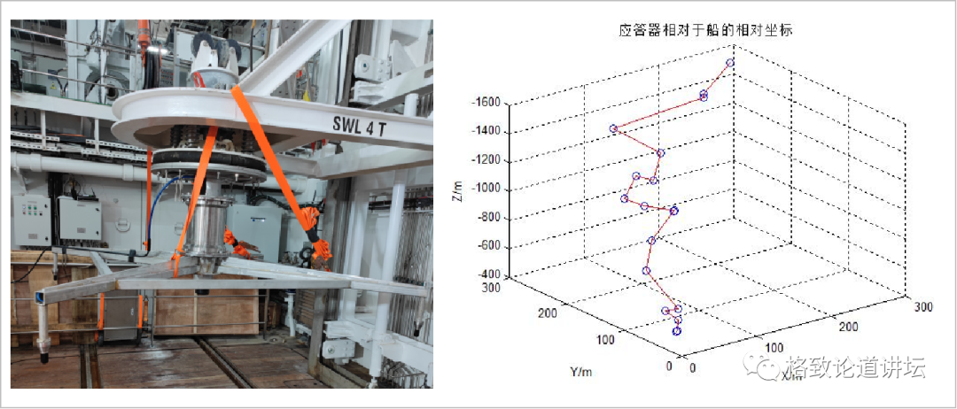
Left: The short -base line positioning system is installed on the Snow Dragon February Pond
Right: Short -based line positioning results

Why didn't we work abroad in this area before? Because although OBS's cloth is relatively easy, we bump a piece of ice with a broken ice boat, find a small ice lake at the stern, and then put it down. But recovery is troublesome. In order to recycle this time, a short -base line acoustic positioning system was installed on the boat. The acoustic positioning system of the short -base line can locate the ups and downs of the OBS and the process of floating process by receiving the signal of OBS, so that we can know where it will surface.
Left: Small Bingjie Lake or open waters
Right: The situation of completely ice coverage
In the Arctic Ocean area, we also imagine two situations. One situation is the usual appearance. OBS floats to the water, which is easy. We can probably know where it has emerged, just go up and recycle. The other is more troublesome. If OBS floats up, what should I do if it happens? The first is to rely on the short -base positioning system just now to predict where it may float under the ice. In addition, use acoustic equipment on the ship for ranging. Then, use the natural caliber of the "Snow Dragon 2" ship to locate the OBS from the head and side side of the boat to determine what position and direction it is on the Cedar boat. For example, how much degree of the bow, how much degree of the tail, or the side side of the side? According to the positioning position, use the cedar boat to hit the ice, smash the ice, so that OBS and some underwater equipment float on the ice, so that we can see it and recycle it.
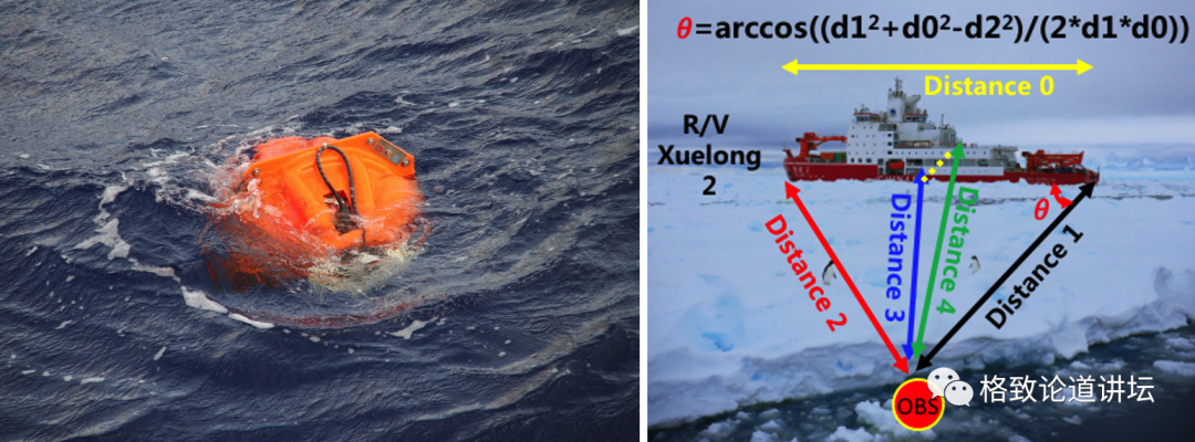
This video was shot at the bow. After the snowon boat hit the ice, it happened to be next to the boat. At this time, the twisted and cranes could not be used, and they could not move the shelters for safety. If it goes back and goes forward, it may be covered by ice again. What should I do at this time? Only when people can go up, we all go up and pull it up and drag it up. So sometimes manpower is still needed.
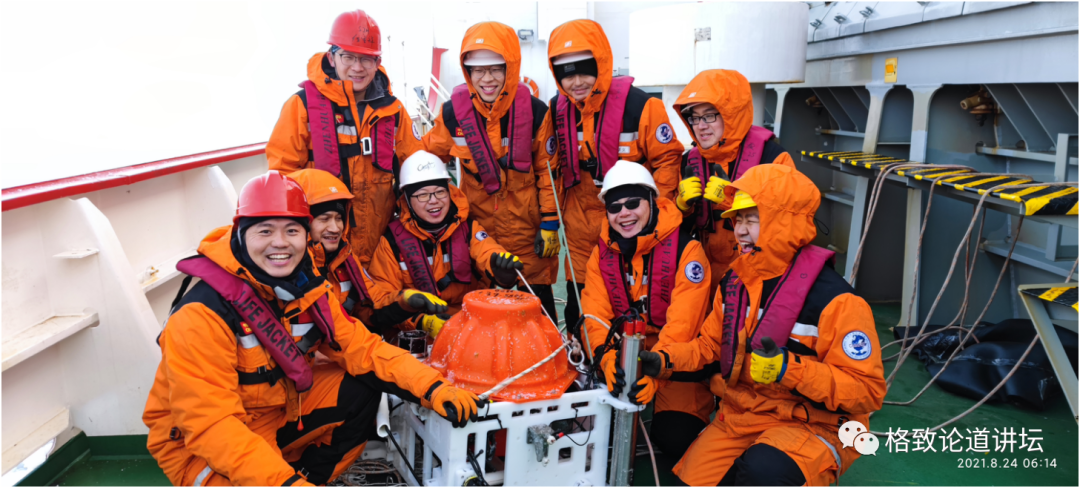
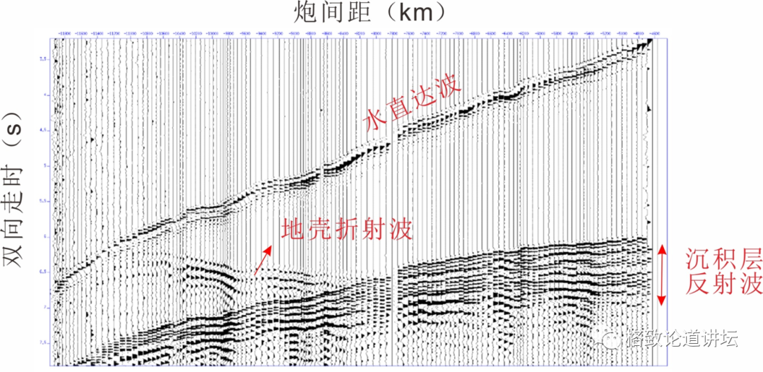
This is the second land electromagnetic instrument (OBEM) we recycled. When the first earth electromagnetic instrument was recycled, a piece of ice peeled off the electronic cabin. After peeling, only the main structure was recycled, but the most important data in the electronic cabin. What we want is these data, but we can only watch it be peeled off by ice. It is a pity. This is the second scene of successful recycling. Everyone is very happy, one by one with a smile. This is a relaxed moment after nervous work, a photo that is very worthy of memories. The water of the B0203 buoy record is straight, the sedimentary layer reflection wave and the crust refraction wave
This is the result analyzed after getting the data: First, the reflection wave of the sedimentation layer, the other is the refraction wave of the crust, and the direct wave of water. Use these to study the structure of the Garker mid -ridge: its sedimentary layer is about how thick, the thickness of the crust, and where the mantle is probably.
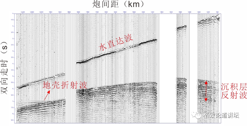
The water direct wave, sedimentary reflection wave and crust refraction wave of the C0115 buoy record
This is another sons buoy data, where the crustal refraction wave appears 9.5 kilometers. About 108 data need to be analyzed, and the analysis work is relatively heavy.
The Gickye mid -ridge detection plan has achieved the purpose we want to achieve, proving that the Chinese have the ability to carry out in -depth detection in high latitude, low temperature, and high -density ice areas, and also point out the direction for other Arctic science teams around the world. Before we, no country was distributed OBS and OBEM under the bottom of the Arctic Ocean Ice, and the successful power was so high. Therefore, in addition to the significance of many scientific discovery, it also has a guiding role in the subsequent Arctic Scientific Examination.
Appreciate the beauty of the Arctic
Completed: 70%///////////
In addition to these difficult and heavy scientific research work, we can also see beautiful scenery and hot life.
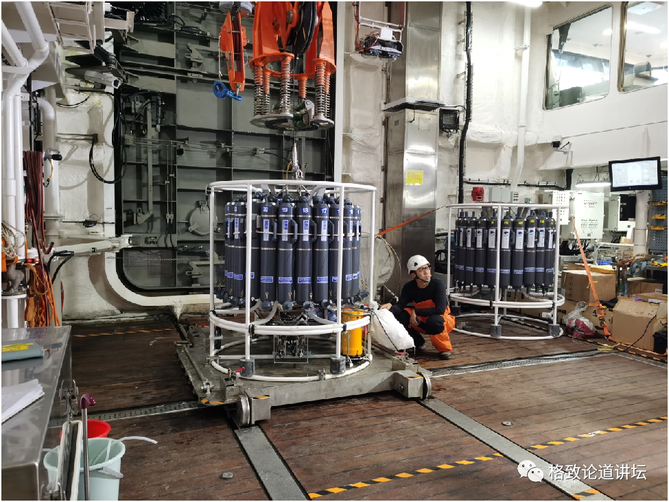
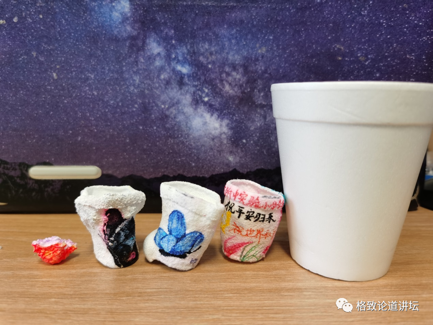
For example, we have a traditional program of high latitudes and deep sea -leaving a memorial to the Arctic. This is an event organized by the union organization before boarding the ship. Let many children draw the paintings they want to draw on the one -time foam cup, and write the blessings they want to write. In the process of doing experiments, the foam cup was tied to the water pickup (CTD), and some meaningful points were put down. Many meaningful points this time are 4000 meters of water depth, using 4000 meters of water to compress the cup.
The cup is pressed all kinds of: some are very beautiful, which is a complete cup shape; some sometimes have a little air in it, and the result will be strange. We all think that air is not resistant to pressure, but in fact, when it comes to the cup, it can still bear 4000 meters of pressure, which is completely unexpected. This is the cup that is pressed, and above is a child's "I wish you a safe return". I think it is very good.
On the left is a lot of pressed cups, which are very beautiful. On the right is the sign of the "Snow Dragon 2" ship we painted on the boat, which is also pressed down.
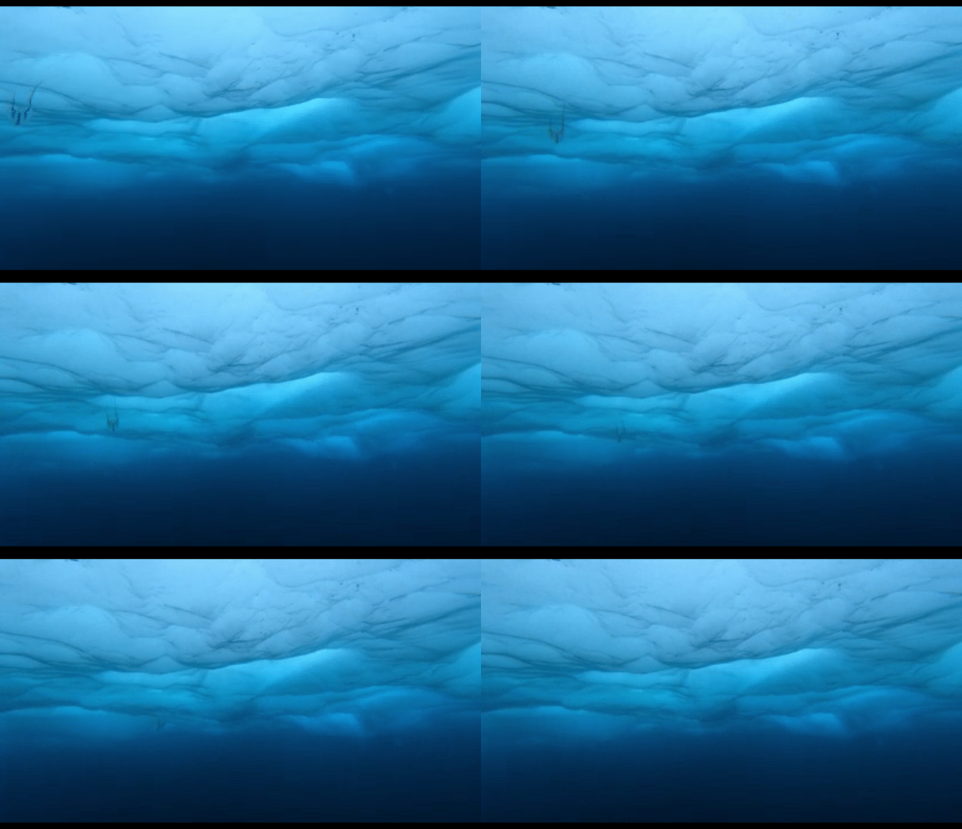
This is a creature in an ice hole that we accidentally encountered under the ice in the process of doing experiments. It is called jellyfish jellyfish, which is different from jellyfish in tropical waters. In a very short time, we saw it.
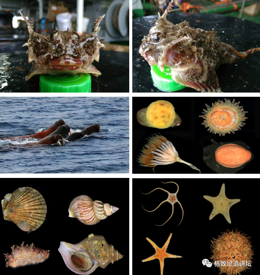
This is a marine creature seen in the seventh Arctic Science Investigation. The ugly and shy one is the devil fish.
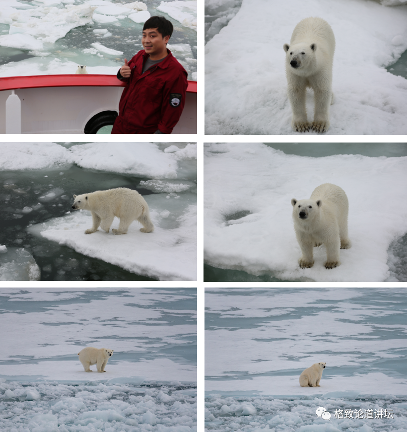
In the seventh investigation, I only saw a polar bear. At that time, we felt that this was the impact of climate warming. But in the 12th Arctic Science Investigation, we saw 16 polar bears.

On September 2nd, in the extreme day, we have completed the Garker Mid -spine plan. Everyone is very happy and relaxed after finishing the experiments. As a result, a polar bear was encountered at this time, near the ship. So we stopped and looked at the polar bear. There is a seal hole nearby, and the polar bear is waiting for its beautiful meals with the cave.
This is a very rare aurora for the Arctic Scientific Examination. Aurora is the phenomenon of the solar wind to the earth, interaction with the earth's magnetic field and the atmosphere of the earth, and then generate. Because the process of our experiment is in the extreme day, only near the aurora zone, it happened to have the content of the homework, just to catch up with the clear night sky in the evening of September, can we have the opportunity to see.
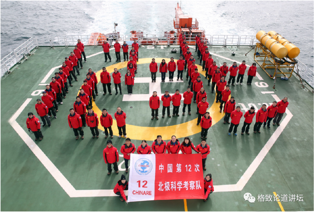
This is the memorial of all our team members through the Arctic Circle.
The above is my Arctic Ocean Story, thank you!
- END -
[Industry Dynamics] Xintong Institute and Aoki jointly released the "Guidelines for the Constitution of Safety Capacity Construction"

Recently, the cooperation unit of Our Journal of Our Journalist and the Xintong In...
[Photography Salon] The "Track" of the August Month -Along the time trajectory, walk through human life

August Monthly theme-TrackAt the midsummer season, the lotus blooming in the park ...